Hanumante River
The Hanumante River is a tributary of the Bagmati River which is almost entirely in the district of Bhaktapur, Nepal.[1][2] It originates from Mahadev Pokhari, Nagarkot, the river flows through Bhaktapur and Thimi Municipality before joining Manohara River, Kathmandu District.[3][4] The Hanumante River has an average width of a minimum of 10m to a maximum of 20m.[3]
| Hanumante River | |
|---|---|
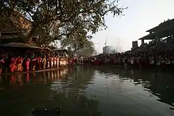 Hanumante River at Hanuman Ghat | |
| Location | |
| Country | Nepal |
| Province | Bagmati Province |
| District | Bhaktapur District Lalitpur District |
| Physical characteristics | |
| Source | Mahadev Pokhari |
| • location | Nagarkot |
| • coordinates | 27.693207086419946°N 85.51977447393836°E |
| Length | 143 square kilometres (55 sq mi) |
| Width | |
| • minimum | 10 metres (33 ft) |
| • average | 20 metres (66 ft) |
In July 2020, the river flooded the district of Bhaktapur due to heavy rainfall.[5]
References
- Sada 2012, p. 1.
- Shrestha 2007, p. 1.
- Sada 2012, p. 2.
- Bhatta & Pandey 2020, p. 3.
- Ojha 2020.
Citations
- Sada, Rajesh (1 February 2012). "Hanumante River: emerging uses, competition and implications". Journal of Science and Engineering. 1: 17–24. doi:10.3126/jsce.v1i0.22489. ISSN 2645-8519.
- Shrestha, Junu (2007). "Identifying the potential impacts on Hanumante River, Bhaktapur and its mitigation measures" (PDF). COnnecting REpositories. Retrieved 27 April 2021.
- Ojha, Anup (22 July 2020). "Hanumante river floods Bhaktapur settlements; town planners say it's human made catastrophe". The Kathmandu Post. Retrieved 27 April 2021.
- Bhatta, Bishnu Prasad; Pandey, Ramesh Kumar (3 February 2020). "Bhaktapur Urban Flood related Disaster Risk and Strategy after 2018". Journal of APF Command and Staff College. 3 (1): 72–89. doi:10.3126/japfcsc.v3i1.27530. ISSN 2616-0242.
Wikimedia Commons has media related to Category:Hanumante River.
This article is issued from Wikipedia. The text is licensed under Creative Commons - Attribution - Sharealike. Additional terms may apply for the media files.