Hanzhong Basin
Hanzhong Basin[2] or Hanzhong Pendi[3] (simplified Chinese: 汉中盆地; traditional Chinese: 漢中盆地; pinyin: Hànzhōng Péndì), reputed to be "a land of fish and rice",[4] is a geographic region located in the southern Shaanxi.[5]
| Hanzhong Basin | |
|---|---|
 Hanzhong Basin  Hanzhong Basin Hanzhong Basin (China) | |
| Geography | |
| Country | China |
| Coordinates | 33°9′0″N 107°10′12″E |

Hanzhong Basin is a large-scale Cenozoic faulted basin, [6] and an important agricultural area of southern Shaanxi province.[7]
Landforms
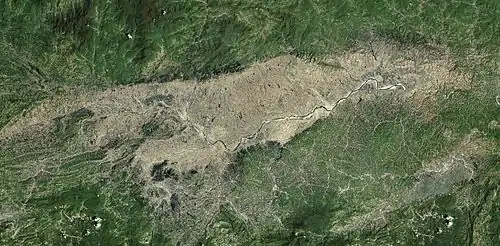
Hanzhong Basin, located in the southwestern Shaanxi, is the largest faulted basin in the upper reaches of the Han River, with the Qinling Mountains to the north and the Daba Mountains to the south.[8] The basin is about 116 km long from east to west and 5~25 km wide from north to south, with a total area of about 2700 km².[9]
Irrigation
The basin has a long history of irrigation, dating back to the first century AD.[10]
Human activities
The era of ancient human activities in the Hanzhong Basin began as late as 600,000 years ago.[11]
References
- JPRS Report: China. Foreign Broadcast Information Service. 1992. pp. 32-.
- China Report: Science and Technology. Foreign Broadcast Information Service. 1985. pp. 206-.
- Encyclopedia of China, Volume 18, Part 2. Encyclopedia of China Publishing House. pp. 163-.
- Foreign Broadcast Information Service (1989). Daily Report: People's Republic of China. National Technical Information Service. pp. 53-.
- The Encyclopedia Americana: Cathedrals-Civil War. Grolier. 2000. pp. 509-. ISBN 978-0-7172-0133-4.
- "Activity identification of the buried segment of Liangshan south margin fault in the west of Hanzhong basin". ResearchGate. 13 July 2013.
- The Encyclopedia Americana, Volume 6. Grolier. 1994. pp. 509-. ISBN 978-0-7172-0125-9.
- "Lithic artifacts excavated from Locality 3 of the Longgangsi site in Hanzhong Basin, Shaanxi Province" (PDF). Chinese Academy of Sciences . 2018-12-04.
- "Research on Structural Features of Hanzhong Basin Based on Gravity Data". CNKI. 2020-06-14.
- "3 Chinese irrigation projects honored as world heritage". State Council Information Office. October 12, 2017.
- "New Paleolithic sites discovered in Hanzhong Basin, Central China". ResearchGate. 13 May 2014.