Henderson Bay
Henderson Bay is a bay on the Aupouri Peninsula, near the very top of the North Island in New Zealand.[1] It is on the eastern side of the peninsula next to the Pacific Ocean and 7 km off New Zealand State Highway 1, 66 km south of Cape Reinga and 10 km north of Houhora. A gravel road connects the bay to the highway.

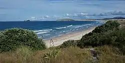
Looking south across Henderson Bay. (The Simmonds Islands are visible on the far left.)

Henderson Bay
Recreation
Henderson Bay is popular for surfing. It has consistent surf, with the beach and reef both having left and right hand breaks, however submerged rocks are a hazard.[2]
History
There is evidence that New Zealand's biggest tsunami took place at Henderson Bay between 1450 and 1480AD, leaving deposits more than 30 metres above sea level and reaching about a kilometre inland from the coast.[3]
References
- "Info About Bay". Archived from the original on 11 August 2011. Retrieved 8 October 2011.
- "Henderson Bay Surf Forecast and Surf Reports (Northland, New Zealand)". www.surf-forecast.com. Retrieved 28 April 2020.
- "Henderson Bay in Aupouri holds tsunami record". www.nzherald.co.nz. Retrieved 28 April 2020.
This article is issued from Wikipedia. The text is licensed under Creative Commons - Attribution - Sharealike. Additional terms may apply for the media files.