Heros Peninsula
Heros Peninsula (Bulgarian: полуостров Херос, romanized: poluostrov Heros, IPA: [poɫuˈɔstrof ˈxɛros]) is the partly ice-free 8.9 km wide peninsula projecting from Foyn Coast, Antarctic Peninsula 13 km southeastwards into Cabinet Inlet. It ends in Spur Point to the southeast.
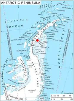
Location of Heros Peninsula in Graham Land, Antarctic Peninsula.
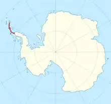
Location of Heros Peninsula (highlited red) on a map of antarctica.
The feature is named after the Thracian god Heros (the Thracian Rider).
Location
Heros Peninsula is centred at 66°33′00″S 63°54′00″W. British mapping in 1974.
Maps
- British Antarctic Territory: Graham Land. Scale 1:250000 topographic map. BAS 250 Series, Sheet SQ 19–20. London, 1974.
- Antarctic Digital Database (ADD). Scale 1:250000 topographic map of Antarctica. Scientific Committee on Antarctic Research (SCAR). Since 1993, regularly upgraded and updated.
References
- Heros Peninsula. SCAR Composite Antarctic Gazetteer.
- Bulgarian Antarctic Gazetteer. Antarctic Place-names Commission. (details in Bulgarian, basic data in English)
External links
- Heros Peninsula. Copernix satellite image
This article includes information from the Antarctic Place-names Commission of Bulgaria which is used with permission.
This article is issued from Wikipedia. The text is licensed under Creative Commons - Attribution - Sharealike. Additional terms may apply for the media files.