Hinkson Creek
Hinkson Creek is a stream in Boone County in the U.S. state of Missouri. Its middle section runs through the city of Columbia, Missouri[1] It was named after Robert Hinkson, a pioneer citizen who lived along its banks.[2] Several trails, conservation areas, and parks are along its path. it eventually empties into Perche Creek southwest of Columbia. The MKT Trail follows the creek in Boone County.
The stream headwaters arise at 39°07′50″N 92°10′51″W[1] approximately two miles northeast of Hallsville at an approximate elevation of 880 feet.[3] The stream flows south-southwest past Hallsville and through the east side of Columbia where it passes under US Route 63 and I-70. South of Columbia the stream turns to the west-southwest and reaches its confluence with Perche Creek[4] at 38°55′19″N 92°24′51″W at an elevation of 558 feet.[1]
The Hinkson Woods Conservation Area is located within meanders of the creek.[5] On June 25, 2021 the Hinkson flooded, reaching a record 23.04 feet in Columbia.[6]
Gallery
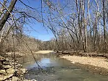
.jpg.webp) Hinkson Creek in February 2015 after snow
Hinkson Creek in February 2015 after snow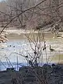 Canada geese near Stadium Blvd in 2019
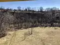 A bluff near Old Highway 63 in 2019
See also
References
- U.S. Geological Survey Geographic Names Information System: Hinkson Creek
- "Boone County Place Names, 1928–1945 (archived)". The State Historical Society of Missouri. Archived from the original on 24 June 2016. Retrieved 4 September 2016.
{{cite web}}: CS1 maint: bot: original URL status unknown (link) - Centralia, MO, 7.5 Minute Topographic Quadrangle, USGS, 1969 (1979 rev)
- Huntsdale, MO, 7.5 Minute Topographic Quadrangle, USGS, 1967 (1985 rev)
- https://mdc.mo.gov/discover-nature/places/hinkson-woods-conservation-area Missouri Department of Conservation
- "Heavy rainfall breaks records in Columbia; Hinkson Creek reaches record flood stage". Columbia Missourian. Columbia, Missouri. June 25, 2021. Retrieved June 25, 2001.