Hodikof Island
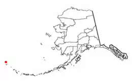
Hodikof Island (52°52'N 173°18'E) is a tiny 0.1-mile-long (160 m) satellite of Attu Island in the Near Islands at the extreme western end of the Aleutian Islands, Alaska.[1] Its name is derived from Hodikof Point, and it lies in Sarana Bay on the east side of Attu.[1] The seaward extension of Hodikof Island is known as Hodikof Reef.[1]
 | |
| Geography | |
|---|---|
| Coordinates | 52°52′20″N 173°17′40″E |
| Archipelago | Near Islands group of the Aleutian Islands |
| Length | .1 mi (0.2 km) |
| Width | .1 mi (0.2 km) |
| Administration | |
United States | |
| State | Alaska |
| Census Area | Aleutians West Census Area |
| Demographics | |
| Population | 0 (2010) |
| Pop. density | 0/km2 (0/sq mi) |
This article is issued from Wikipedia. The text is licensed under Creative Commons - Attribution - Sharealike. Additional terms may apply for the media files.