Hodkovice nad Mohelkou
Hodkovice nad Mohelkou (until 1949 Hodkovice; German: Liebenau) is a town in Liberec District in the Liberec Region of the Czech Republic. It has about 3,000 inhabitants. The historic town centre is well preserved and is protected by law as an urban monument zone.
Hodkovice nad Mohelkou | |
|---|---|
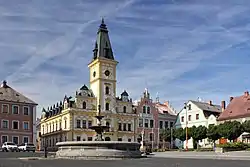 T. G. Masaryka Square with the town hall | |
 Flag  Coat of arms | |
 Hodkovice nad Mohelkou Location in the Czech Republic | |
| Coordinates: 50°39′57″N 15°5′23″E | |
| Country | |
| Region | Liberec |
| District | Liberec |
| First mentioned | 1352 |
| Government | |
| • Mayor | Markéta Khauerová |
| Area | |
| • Total | 13.49 km2 (5.21 sq mi) |
| Elevation | 367 m (1,204 ft) |
| Population (2023-01-01)[1] | |
| • Total | 2,989 |
| • Density | 220/km2 (570/sq mi) |
| Time zone | UTC+1 (CET) |
| • Summer (DST) | UTC+2 (CEST) |
| Postal code | 463 42 |
| Website | www |
Administrative parts
Villages of Jílové, Radoňovice, Záskalí and Žďárek are administrative parts of Hodkovice nad Mohelkou.
Geography
Hodkovice nad Mohelkou is located about 9 km (6 mi) south of Liberec. The southern part of the municipal territory with the built-up area lies in the Jičín Uplands. The northern part lies in the Ještěd–Kozákov Ridge and includes the highest peak of Hodkovice nad Mohelkou, Javorník at 684 m (2,244 ft) above sea level.
History
The first settlement in the area of today's town was probably founded in the 11th century. The first written mention of Hodkovice is from 1352. In 1806, a great fire destroyed most of the town. The archive also burned down, so it is not known when Hodkovice was promoted to a town.[2]
Demographics
|
|
| ||||||||||||||||||||||||||||||||||||||||||||||||||||||
| Source: Censuses[3][4] | ||||||||||||||||||||||||||||||||||||||||||||||||||||||||
Transport
The I/35 expressway (part of the European route E442) passes through the town.
The town lies on the railway line leading from Liberec to Jaroměř.
Hodkovice nad Mohelkou Airport (ICAO code: LKHD) is a public domestic airport, one of three airports serving the Liberec Region.[5]
Education
There are two schools in Hodkovice nad Mohelkou, a kindergarten and a primary school. The town founds both organizations.[6]
Sights
The Church of Saint Procopius was built in 1717 on the site of a wooden church, which was destroyed by a fire in 1692.[7]
The main landmark of the town square is the town hall. It was built in 1811, after the previous building burned down. In 1889, it was rebuilt to its current appearance. Other valuable buildings on the square are Marian column from the early 18th century, and the fountain from 1886, which was removed from the square in 1946 and returned in the 1990s.[7]
Gallery
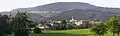 View from the south
%252C_Hodkovice_nad_Mohelkou.JPG.webp) Church of Saint Procopius
Church of Saint Procopius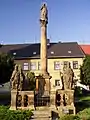 Marian column
References
- "Population of Municipalities – 1 January 2023". Czech Statistical Office. 2023-05-23.
- "Nejstarší zprávy o Hodkovicích" (in Czech). Město Hodkovice nad Mohelkou. Retrieved 2023-03-29.
- "Historický lexikon obcí České republiky 1869–2011 – Okres Liberec" (in Czech). Czech Statistical Office. 2015-12-21. pp. 5–6.
- "Population Census 2021: Population by sex". Public Database. Czech Statistical Office. 2021-03-27.
- "Letiště v Libereckém kraji". Doprava v Libereckém kraji (in Czech). Liberec Region. 2010. Retrieved 2023-01-02.
- "Informace o městě" (in Czech). Město Hodkovice nad Mohelkou. Archived from the original on 2022-10-17. Retrieved 2022-10-17.
- "Památky ve městě" (in Czech). Město Hodkovice nad Mohelkou. Retrieved 2021-08-16.
- "Partnerská spolupráce" (in Czech). Město Hodkovice nad Mohelkou. 2019-09-27. Retrieved 2020-07-22.