Hogganvik runestone
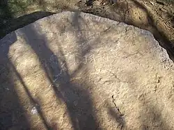
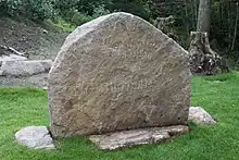
The Hogganvik runestone is a fifth-century runestone, bearing an Elder Futhark inscription, that was discovered in September 2009 by Arnfinn Henriksen, a resident of Hogganvik, in the Sånum-Lundevik area of Mandal, Vest-Agder, Norway, while working in the garden.


Description
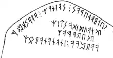
The Hogganvik runestone is a stone slab of about 1.5 square metres (16 sq ft), weighing approximately 800 kilograms (1,800 lb). It was lying face down and the runic inscription is therefore well preserved. The inscription, which is in Proto-Norse, can be approximately dated to between 350 and 500 CE[1] and consists of 62 characters, one a bind-rune. This is an exceptionally long text for the early period, either the second longest after that of the Tune stone (known since 1627),[2][3] or possibly the third; the inscription on the Rö stone has missing and illegible runes.[4]
A report was issued in October 2009 by runologist James E. Knirk,[1] and provides a transliteration of the inscription.
Text
- Original runes
- [ᛊ]ᚲᛖᛚᛒᚨᚦᛖᚹᚨᛊ᛬ᛊ[ᛏ]ᚨᛁᚾᚨᛉ᛬ᚨᚨᚨᛊᚱᛈᚲᚠ
- ᛖᚲᚾᚨᚢᛞᛁᚷᚨᛊᛏᛁᛉ
- ᛖᚲᛖᚱᚨᚠᚨᛉ
- ᚨᚨᚱᛈᚨᚨ᛬ᛁᚾᚨᚾᚨᚾᚨᛚᛟᛉ/ᚾᚨᛒᛟᛉ/(ᚾᚨᚹᛟᛉ)
- Raw transliteration
- [s]kelbaþewas:s[t]ainaz:aaasrpkf
- eknaudigastiz
- ekerafaz
- aarpaa:inananaloz/naboz/(nawoz)
Interpretation
- Skelba-þewaz’s ["Shaking-servant’s" (personal name)] stone [=(grave) monument] aaasrpkf (a meaningless sequence of letters used as an incantation).
- I [=the rune carver] [am called] Naudigastiz [="Need-guest" (personal name)]; (name of the Runecarver)
- I, [nicknamed] the Wolverine.
- aarpaa (a non meaningful sequence of letters used as an incantation) ?Within/From within the ?wheel-nave/?cabin-corner [or: ?needle]. (Place)[1]
The stone is a memorial. The meaningless sequences, with the repeated a runes, may be alphabet magic. The fourth line is hard to interpret. The middle two lines name the carver of the runes.[1]
Archaeological investigation
In May 2010 an archaeological investigation was carried out. The face of the stone with the inscription was shown to be more weathered than the underside, indicating it had been raised over a grave, and a large Iron Age burial was found under the site, but was not excavated.
See also
References
- Knirk, James E. (27 October 2009). "Revised preliminary report: Runic inscription from Hogganvik, Mandal, Vest-Agder (2009)" (PDF). Archived from the original (PDF) on 4 June 2011.
- "Fant runestein i hagen" (in Norwegian). Norwegian Broadcasting Corporation. 29 September 2009.
- "Kan ha funnet til nå ukjent runestein". Verdens Gang (in Norwegian). 28 September 2009.
- "Hogganvik Proto-Norse Runestone, Norway (Sept. 2009)". Museum of Cultural History, Oslo. Archived from the original on 29 April 2011.
Further reading
- Knirk, James E. (2011). "Hogganvik-innskriften: en hard runologisk nøtt". Viking (in Norwegian). Vol. 74. pp. 25–39. ISSN 0332-608X.
- Schulte, Michael (2011). "Die sprachliche Deutung der Hogganvik-Inschrift. Ergänzungen zum vorläufigen Bericht". Amsterdamer Beiträge zur älteren Germanistik (in German). 67: 57–68. doi:10.1163/9789401200783_006. ISSN 0165-7305.
- Schulte, Michael (2013). "The Norwegian Hogganvik Stone as an Emblem of Social Status and Identity" (PDF). Journal of the North Atlantic Special. 4: 120–128. ISSN 1935-1933. Archived from the original (PDF) on 14 July 2014.
External links
 Media related to Hogganvik runestone at Wikimedia Commons
- "Kulturminnesøk: Hogganviksteinen" (in Norwegian). Norwegian Directorate for Cultural Heritage. Archived from the original on 29 June 2013. Retrieved 6 October 2013.