Holtanna Peak
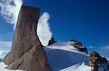
Holtanna Peak is a peak, 2,650 metres (8,700 ft) high, whose eastern portion is occupied by a small cirque glacier, standing 1 nautical mile (2 km) north of the Mundlauga Crags in the eastern part of Fenriskjeften Mountain in Queen Maud Land, Antarctica. It was mapped from surveys and air photos by the Sixth Norwegian Antarctic Expedition (1956–60) and named Holtanna (the hollow tooth).[1]
| Holtanna Peak | |
|---|---|
| Highest point | |
| Elevation | 2,650 m (8,690 ft) |
Holtanna Peak
References
![]() This article incorporates public domain material from "Holtanna Peak". Geographic Names Information System. United States Geological Survey.
This article incorporates public domain material from "Holtanna Peak". Geographic Names Information System. United States Geological Survey.
This article is issued from Wikipedia. The text is licensed under Creative Commons - Attribution - Sharealike. Additional terms may apply for the media files.