Holzbach (Hochwald)
The Holzbach is a stream in the state of Saarland, Germany, in the uplands of the Schwarzwälder Hochwald. It flows into the Losheimer Bach at Nunkirchen.
| Holzbach | |
|---|---|
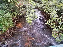 The Holzbach at Thailen | |
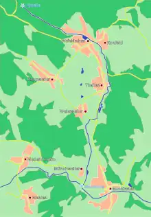 Map of the Holzbach | |
| Location | |
| Location | Hunsrück
northern Saarland
|
| Reference no. | DE: 264664 |
| Physical characteristics | |
| Source | |
| • location | north of Weiskirchen |
| • coordinates | 49°34′42″N 6°46′27″E |
| • elevation | 565 m above sea level (NN) |
| Mouth | |
• location | at Nunkirchen into the Losheimer Bach |
• coordinates | 49°29′29.5″N 6°49′10″E |
• elevation | 256 m above sea level (NN) |
| Length | 13.23 km [1] |
| Basin size | 26.0 km² [1] |
| Basin features | |
| Progression | Losheimer Bach → Prims → Saar → Moselle → Rhine → North Sea |
| River system | Rhine |
| Landmarks |
|

Bridge over the Holzbach in the Kneipp facility at Thailen
Geography
Course
The Holzbach rises in the Hunsrück mountains at a height of 565 m above NHN north of Weiskirchen and empties into the Losheimer Bach at Nunkirchen at a height of 256 m.
Tributaries
- Flachsbach (left)
- Schlittentaler Bach (left)
- Ruwerbach (right)
Settlements
The Holzbach flows through the following settlements:
- Weiskirchen
- Konfeld
- Thailen
- Batschweiler
- Weierweiler
- Münchweiler
- Nunkirchen
See also
References
- WRRL land management plan for the Saarland December 2009, p. 11 at the Wayback Machine (archived 2017-03-30) (pdf; 783 kB)
This article is issued from Wikipedia. The text is licensed under Creative Commons - Attribution - Sharealike. Additional terms may apply for the media files.