Hong'an County
Hong'an County (simplified Chinese: 红安县; traditional Chinese: 紅安縣; pinyin: Hóng'ān Xiàn), formerly named Huang'an County (黄安县; 黃安縣; Huáng'ān Xiàn; Hwangan), located to the north of provincial capital Wuhan, is a county under jurisdiction of Huanggang, Hubei province, People's Republic of China.
Hong'an County
红安县 | |
|---|---|
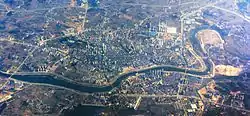 Hong'an County from above | |
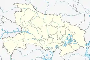 Hong'an Location in Hubei | |
| Coordinates (Hong'an government): 31°17′17″N 114°37′05″E | |
| Country | People's Republic of China |
| Province | Hubei |
| Prefecture-level city | Huanggang |
| Time zone | UTC+8 (China Standard) |
| Website | www |
Hong'an is famous for how many generals in the People's Liberation Army originally hailed from it. In the early 1950s, there were over 200 generals from Hong'an, far more than any other county in China. It earned Hon'an the nickname "County of the Generals".
The former military leader and national President of China, Li Xiannian (1909–1992), was born in Hong'an.
History
In 845 BC, Marquis Wen (文侯) Huang Meng (黃孟) (aka Huang Zhang; 黃璋) moved the capital of the State of Huang from Yicheng to Huangchuan (present-day Huangchuan, Henan). Huang Xi's descendants ruled the State of Huang until 648 BC when it was destroyed and conquered by the State of Chu. The Marquis of Huang, Marquis Mu (穆侯) Huang Qisheng (黃企生), fled to the state of Qi. The people of Huang were forced to relocate to Chu. They settled in the region of present-day Hubei province, in a region known as the Jiangxia Commandery (江夏郡) during the Han dynasty (206 BC-AD 220). There are many places in this region today that were named after Huang e.g. Huanggang, Huangpi, Huangmei, Huangshi, Huang'an (now Hong'an), Huangzhou etc. A large number of the people of Huang were also relocated to regions south of the Yangtze River.
During the Chinese Civil War, Huang'an County (as it was then known) was a stronghold of the Chinese Communist Party. It was in Huang'an where in November 1927 Communist guerrillas founded the first peasants' government that would eventually evolve into the future Eyuwan soviet. It was also the location where Communist General Xu Haidong founded the Seventh Red Army with a handful of recruits.[1] From the core of Huang'an, Macheng, and Guangshan counties, the Eyuwan Soviet would gradually expand to become the second-largest soviet republic in China, with over one million inhabitants.[2] The Red Army units based in Eyuwan recruited heavily from Huang'an, and many natives of the county went on to serve in high ranks of the People's Liberation Army. In the early 1950s, over 200 PLA generals hailed from Huang'an. Two of these men, Dong Biwu and Li Xiannian, both would go on to serve as President of the People's Republic of China.[3]
Geography
Administrative divisions
Hong'an County administers 13 township-level divisions:[4][5][6]
| # | Name | Chinese (S) | ||||
|---|---|---|---|---|---|---|
| Towns | ||||||
| 1 | Chengguan | 城关镇 | ||||
| 2 | Qiliping | 七里坪镇 | ||||
| 3 | Huajiahe | 华家河镇 | ||||
| 4 | Ercheng | 二程镇 | ||||
| 5 | Shangxinji | 上新集镇 | ||||
| 6 | Gaoqiao | 高桥镇 | ||||
| 7 | Mi'ersi | 觅儿寺镇 | ||||
| 8 | Baliwan | 八里湾镇 | ||||
| 9 | Taipingqiao | 太平桥镇 | ||||
| 10 | Yongjiahe | 永佳河镇 | ||||
| Township | ||||||
| 11 | Xinghua | 杏花乡 | ||||
| Other Areas | ||||||
| 12 | Huolianfan Tea Farm | 火连畈茶场 | ||||
| 13 | Tiantaishan Scenic Area | 天台山风景区管理处 | ||||
Climate
| Climate data for Hong'an (1991–2020 normals, extremes 1981–2010) | |||||||||||||
|---|---|---|---|---|---|---|---|---|---|---|---|---|---|
| Month | Jan | Feb | Mar | Apr | May | Jun | Jul | Aug | Sep | Oct | Nov | Dec | Year |
| Record high °C (°F) | 19.6 (67.3) |
27.4 (81.3) |
30.5 (86.9) |
33.6 (92.5) |
36.5 (97.7) |
37.9 (100.2) |
39.7 (103.5) |
39.0 (102.2) |
37.8 (100.0) |
34.4 (93.9) |
29.3 (84.7) |
22.1 (71.8) |
39.7 (103.5) |
| Average high °C (°F) | 8.0 (46.4) |
11.2 (52.2) |
16.1 (61.0) |
22.5 (72.5) |
27.0 (80.6) |
30.0 (86.0) |
32.5 (90.5) |
32.4 (90.3) |
28.7 (83.7) |
23.3 (73.9) |
16.9 (62.4) |
10.4 (50.7) |
21.6 (70.9) |
| Daily mean °C (°F) | 3.2 (37.8) |
6.1 (43.0) |
10.7 (51.3) |
16.9 (62.4) |
21.9 (71.4) |
25.4 (77.7) |
28.2 (82.8) |
27.6 (81.7) |
23.4 (74.1) |
17.6 (63.7) |
11.1 (52.0) |
5.3 (41.5) |
16.5 (61.6) |
| Average low °C (°F) | −0.2 (31.6) |
2.3 (36.1) |
6.6 (43.9) |
12.3 (54.1) |
17.5 (63.5) |
21.7 (71.1) |
24.8 (76.6) |
24.1 (75.4) |
19.5 (67.1) |
13.4 (56.1) |
6.9 (44.4) |
1.5 (34.7) |
12.5 (54.6) |
| Record low °C (°F) | −9.2 (15.4) |
−7.8 (18.0) |
−4.4 (24.1) |
0.3 (32.5) |
6.9 (44.4) |
11.6 (52.9) |
18.5 (65.3) |
15.5 (59.9) |
10.4 (50.7) |
0.4 (32.7) |
−4.6 (23.7) |
−16.2 (2.8) |
−16.2 (2.8) |
| Average precipitation mm (inches) | 38.3 (1.51) |
49.2 (1.94) |
76.9 (3.03) |
106.1 (4.18) |
133.3 (5.25) |
204.9 (8.07) |
251.1 (9.89) |
136.7 (5.38) |
66.3 (2.61) |
62.0 (2.44) |
48.6 (1.91) |
24.9 (0.98) |
1,198.3 (47.19) |
| Average precipitation days (≥ 0.1 mm) | 8.2 | 9.0 | 11.0 | 10.6 | 11.5 | 10.7 | 11.6 | 10.0 | 7.7 | 8.8 | 8.4 | 6.5 | 114 |
| Average snowy days | 4.4 | 2.7 | 1.0 | 0 | 0 | 0 | 0 | 0 | 0 | 0 | 0.5 | 1.3 | 9.9 |
| Average relative humidity (%) | 73 | 74 | 73 | 72 | 74 | 80 | 81 | 80 | 75 | 73 | 73 | 71 | 75 |
| Mean monthly sunshine hours | 102.5 | 103.1 | 131.4 | 153.9 | 164.8 | 152.3 | 191.8 | 201.2 | 162.8 | 149.8 | 132.6 | 119.9 | 1,766.1 |
| Percent possible sunshine | 32 | 33 | 35 | 40 | 39 | 36 | 45 | 49 | 44 | 43 | 42 | 38 | 40 |
| Source: China Meteorological Administration[7][8] | |||||||||||||
References
- Benton 1992, p. 310.
- Benton 1992, p. 311.
- Huang 2016, Chapter 1.
- 红安简介 (in Simplified Chinese). Hong'an County People's Government. Retrieved 9 January 2018.
行政区划:红安辖13个乡镇(场),分别为城关镇(面积117.94平方公里)(面积为平方公里,下同),杏花乡(面积166.41)、七里坪镇(面积351.33),华家河镇(面积167.25)、二程镇(面积129.25)、上新集镇(面积85.7)、高桥镇(面积150.06)、觅儿寺镇(面积89.64)、八里湾镇(面积100.6)、太平桥镇(面积75.15)、永佳河镇(面积225.81)、火连畈茶场(面积13.79)、天台山风景区管理处。村委会396个,村民小组3814个。
- 黄冈市乡镇(街道)名录 [Huanggang City Township-level Divisions List] (in Simplified Chinese). XZQH. 15 August 2014. Retrieved 9 January 2018.
红安县辖10个镇、1个乡:城关镇、七里坪镇、华家河镇、二程镇、上新集镇、高桥镇、觅儿寺镇、八里湾镇、太平桥镇、永佳河镇、杏花乡。县政府驻城关镇。
- 中国地质邮政编码簿(2015). China Post. 2015. p. 594.
- 中国气象数据网 – WeatherBk Data (in Simplified Chinese). China Meteorological Administration. Retrieved 23 September 2023.
- 中国气象数据网 (in Simplified Chinese). China Meteorological Administration. Retrieved 23 September 2023.
Bibliography
- Huang, Chuanhui (2016). Migrant Workers and the City: Generation Now. Fernwood Publishing.
- Benton, Gregor (1992). Mountain Fires: The Red Army's Three-year War in South China, 1934-1938. Los Angeles: University of California Press.