Melancthon, Ontario
Melancthon is a rural Canadian township in the northwest corner of Dufferin County, Ontario, bordered on the east by Mulmur Township, Amaranth Township and East Luther Grand Valley to the south, Southgate Township to the west, and the Municipality of Grey Highlands to the north. The township does not include the town of Shelburne on its southern border. It has one of the lowest population densities in southwestern Ontario.
Melancthon | |
|---|---|
| Township of Melancthon | |
 | |
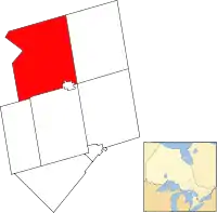 Melancthon Township within Dufferin County | |
 Melancthon Melancthon in southern Ontario | |
| Coordinates: 44°9′N 80°16′W | |
| Country | |
| Province | |
| County | Dufferin |
| Settled | 1818 |
| Incorporated | January 1, 1853 |
| Government | |
| • Mayor | Darren White |
| • Federal riding | Dufferin—Caledon |
| • Prov. riding | Dufferin—Caledon |
| Area | |
| • Land | 310.79 km2 (120.00 sq mi) |
| Population (2016)[1] | |
| • Total | 3,008 |
| • Density | 9.7/km2 (25/sq mi) |
| Time zone | UTC-5 (EST) |
| • Summer (DST) | UTC-4 (EDT) |
| Postal Code | L0N |
| Area code(s) | 519, 226, 548 |
| Website | melancthontownship.ca |
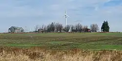
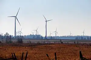
The primary industry of the township is farming, with limited beef, dairy, sheep and horse farming. It is also home to the Melancthon EcoPower Centre wind farm.
The township was founded in 1853 as a part of Grey County and transferred to Dufferin County in 1881. Township council currently comprises Mayor Darren White, a deputy mayor and three councillors.
Communities
The township of Melancthon comprises a number of villages and hamlets, including the following communities: Auguston, Corbetton, Horning's Mills, Masonville, Mayburne, Melancthon, Ostrander, Redickville, Riverview, Shrigley, and Wrigglesworth Corner.
Demographics
| Year | Pop. | ±% |
|---|---|---|
| 1991 | 2,447 | — |
| 1996 | 2,607 | +6.5% |
| 2001 | 2,796 | +7.2% |
| 2006 | 2,895 | +3.5% |
| 2011 | 2,839 | −1.9% |
| 2016 | 3,008 | +6.0% |
| [2][3][1] Population in 2001 was 2,739 when boundary adjustments in 2006 were taken into account | ||
In the 2021 Census of Population conducted by Statistics Canada, Melancthon had a population of 3,132 living in 1,035 of its 1,104 total private dwellings, a change of 4.1% from its 2016 population of 3,008. With a land area of 310.39 km2 (119.84 sq mi), it had a population density of 10.1/km2 (26.1/sq mi) in 2021.[4]
See also
References
- "Census Profile, 2016 Census: Melancthon, Township". Statistics Canada. 8 February 2017. Retrieved June 11, 2019.
- Statistics Canada: 1996, 2001, 2006 census
- "Melancthon, Ontario (Code 3522019) census profile". 2011 Census of Population. Statistics Canada. Retrieved 2012-08-14.
- "Population and dwelling counts: Canada, provinces and territories, census divisions and census subdivisions (municipalities), Ontario". Statistics Canada. February 9, 2022. Retrieved April 2, 2022.
External links
 Media related to Melancthon, Ontario at Wikimedia Commons
- Official website
Places adjacent to Melancthon, Ontario | ||||||||||||||||
|---|---|---|---|---|---|---|---|---|---|---|---|---|---|---|---|---|
| ||||||||||||||||