Horomatangi Reef
The Horomatangi Reef or reefs is a feature of Lake Taupō, in the central North Island of New Zealand.
| Horomatangi Reef eruptions | |
|---|---|
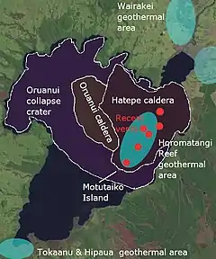
 Volcanic features of Lake Taupō. Red are active vents in last 2500 odd years. Blue are current active geothermal systems. | |
| Volcano | Lake Taupō |
| Date | Most recently about 260 AD, but most significant 232 AD Unit Y (Hatepe eruption) and 1460 BCE Unit S |
| Start date | 1460 BCE Unit S |
| End date | 260 AD |
| Type | Phreatomagmatic, Ultra-Plinian |
| Location | Lake Taupō, North Island, New Zealand 38.8°S 176.00°E |
| VEI | 6 (Unit S), 7 (Unit Y) |
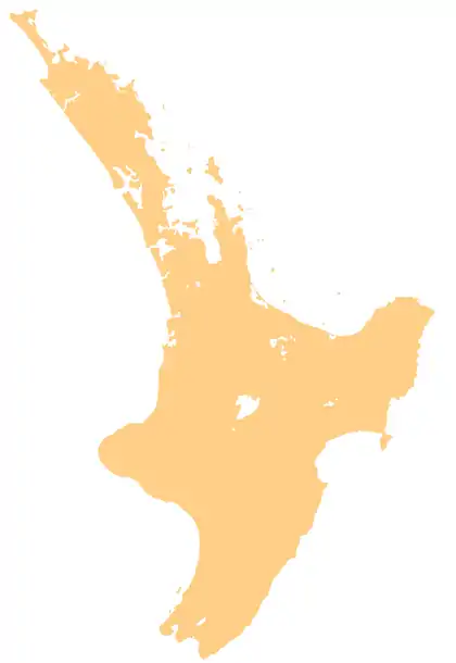
 Horomatangi Reef (New Zealand)  Horomatangi Reef (North Island) Horomatangi Reef location within New Zealand | |
The reef is named after Horomātangi (Horo-matangi),[1] the tāniwha or water monster of the lake, who is said to reside in a cave adjacent to the nearby Motutaiko Island to the south.[2] The name Horomatangi Reefs perhaps better reflects its complex inner and outer structure with the shallow reefs separated by very deep areas, so tends to be used in the geological literature, while the term reef tends to be used geographically.
Geology
The reefs are at a high heat-output geothermal hot spot area within the Taupō Volcano.[3] This is related to rhyolitic lava domes extruded after explosive volcanism.[4] The explosive eruptions include the VEI 7 Hatepe eruption of 232 ± 10 CE that ejected over 120 km3 (29 cu mi) of material (also known as Horomatangi Reef Unit Y eruption)[5] and its linear line of eruption centres,[6] as well as its own namesake Horomatangi, Unit S VEI 6 eruption of about 1460 BCE.[5] Accordingly the reef is perhaps best regarded as a complex volcano within the caldera of another complex volcano. There is one area of 500 m (1,600 ft) diameter dropping to a depth of over 164 m (538 ft) below mean lake level.[7]
Contemporary volcanic activity
Recent periods of volcanic unrest of the Taupō Volcano have been associated with earthquake swarms centred in the area of the Horomatangi Reef. From February to October 2022 during a period of volcanic unrest the reef had inflated upwards by a mean of 24 mm (0.94 in) relative to other reference points around Lake Taupō.[8] A shallow magnitude 5.7 earthquake occurred on 30th November 2022 causing a further sudden upwards inflation of 180 mm (7.1 in), being the largest amount of uplift ever recorded to date for the reef.[9]
References
- "New Zealand Gazetteer: Horomatangi Reef". LINZ (Toitū Te Whenua). Retrieved 28 March 2023.
- Stout, Sir Robert. "Lake Taupo". NZTEC. Retrieved 28 March 2023.
- Whiteford, P. C. (1996). "Heat flow in the sediments of Lake Taupo, New Zealand". Tectonophysics. 257 (1): 81–92. doi:10.1016/0040-1951(95)00122-0. PMC 5613013. PMID 28947829. Retrieved 24 July 2022.
- Houghton, B.F. (2007). Field Guide – Taupo Volcanic Zone of the Archived 3 March 2016 at the Wayback Machine
- "Smithsonian Global Volcano Program:Taupo". Retrieved 24 July 2022.
- Illsley-Kemp, Finnigan; Barker, Simon J.; Wilson, Colin J. N.; Chamberlain, Calum J.; Hreinsdóttir, Sigrún; Ellis, Susan; Hamling, Ian J.; Savage, Martha K.; Mestel, Eleanor R. H.; Wadsworth, Fabian B. (1 June 2021). "Volcanic Unrest at Taupō Volcano in 2019: Causes, Mechanisms and Implications". Geochemistry, Geophysics, Geosystems. 22 (6): 1–27. doi:10.1029/2021GC009803.
- Irwin, J. 1972: Lake Taupo provisional bathymetry. 1:50,000. New Zealand Oceanographic Institute Chart, Lake Series.
- "Volcanic Activity BulletinTP - 2022/06 Tue Oct 11 2022 3:30 PM; Taupo Volcano". Retrieved 2022-10-12.
- "Taupō Earthquake Update: Published: Wed Dec 14 2022 12:13 PM". Retrieved 2023-03-28.