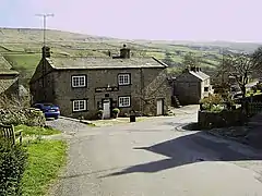
Horsehouse
Horsehouse is a village in Coverdale in the Yorkshire Dales, North Yorkshire, England. It is listed as a hamlet in many texts, but the presence of the church makes it a village.[1][2][3] The River Cover runs near the village, and it lies some 6 miles (9.7 km) and 8.5 miles (13.7 km) south-west of Middleham and Leyburn respectively, at an elevation of 820 feet (250 m).[1][4][5]
| Horsehouse | |
|---|---|
 The Thwaite Arms | |
.svg.png.webp) Horsehouse Location within North Yorkshire | |
| Civil parish | |
| Unitary authority | |
| Ceremonial county | |
| Region | |
| Country | England |
| Sovereign state | United Kingdom |
| Police | North Yorkshire |
| Fire | North Yorkshire |
| Ambulance | Yorkshire |
Most of the settlements in Highdale (the parish that Horsehouse is within), were first described in the 13th century, but Horsehouse was not recorded until the 15th century.[6] The village is so named because it provided facilities for horses using the packhorse routes that crossed in the village. One route crossed over into Wharfedale, which is the route that still exists into Kettlewell over Park Rash.[7][8][9] Horsehouse was historically in the wapentake of Hang West, the chapelry of Coverham and in the Leyburn Rural District.[10]
The village is home to St Botolph's Church, a Grade II listed building rebuilt between 1867 and 1869,[11][12] and the Thwaite Arms public house, built in 1808.[13] St Botolph's was recorded in an indenture of 1530 from Coverham Abbey, stating a canon would officiate at the church.[14] It had existed before this time, but it is unknown for how long.[15] There are five dedications to St Botolph in Yorkshire. St Botolph became the patron saint of boundaries, travel and trade, so it is thought the church dedication reflects the previous trades of the packhorse routes.[14] A Wesleyan Methodist chapel was erected in the Horsehouse in 1828, and the communities of the Wesleyan's and the Primitive Methodists reunited in 1933.[16] The chapel at Horsehouse is now a private dwelling.[17]
References
- "Horsehouse Richmondshire". getoutside.ordnancesurvey.co.uk. Retrieved 23 September 2023.
- Baker, W. P. (1971). The English village. Westport: Greenwood Press. p. 11. ISBN 0837155525.
- Roberts, Brian K. (1987). The making of the English village : a study in historical geography. Harlow: Longman Scientific & Technical. p. 6. ISBN 0582301432.
- "Genuki: Coverham Supplementary, Yorkshire (North Riding)". genuki.org.uk. Retrieved 23 September 2023.
- "Horsehouse North Riding". visionofbritain.org.uk. Retrieved 23 September 2023.
- Joynes 2006, p. 34.
- Mitchell, W. R. (1999). The story of the Yorkshire Dales. Chichester: Phillimore. p. 107. ISBN 1860770886.
- Peach, Howard (2004). Curious tales of old North Yorkshire. Wilmslow: Sigma. p. 71. ISBN 1-85058-793-0.
- "Kettlewell". yorkshiredales.org.uk. Retrieved 23 September 2023.
- Guide No. 6: North Yorkshire Gazetteer of Townships and Parishes. Northallerton: North Yorkshire County Council. 2021 [1986]. pp. 9, 17. ISBN 0 906035 29 5.
- Historic England. "Church of St Botolph (1131405)". National Heritage List for England. Retrieved 11 October 2019.
- "The Parish of Middleham, Coverdale, East Witton and Thornton Steward | Coverdale". jervaulxchurches.co.uk. Retrieved 23 September 2023.
- Historic England. "Thwaite Arms Inn (1131401)". National Heritage List for England. Retrieved 11 October 2019.
- Joynes 2006, p. 47.
- Hartley, Marie; Ingilby, Joan (1991). The Yorkshire Dales. Otley: Smith Settle. p. 303. ISBN 1870071727.
- Joynes 2006, p. 311.
- Hogg, Chris (2013). Wensleydale & Coverdale through time. Stroud: Amberley Publishing. p. 55. ISBN 978-1-4456-1941-5.
External links
 Media related to Horsehouse at Wikimedia Commons
- The ancient parish of Coverham: historical and genealogical information at GENUKI.