Rural City of Horsham
The Rural City of Horsham is a local government area in Victoria, Australia, located in the western part of the state. It covers an area of 4,267 square kilometres (1,647 sq mi) and in June 2018, had a population of 19,875.[1] It includes the towns of Brimpaen, Dadswells Bridge, Dooen, Haven, Horsham, Laharum, Natimuk, Noradjuha and Pimpinio. It was formed in 1995 by the amalgamation of the City of Horsham, most of the Shire of Wimmera and Shire of Arapiles, and part of the Shire of Kowree.[2]
| Rural City of Horsham Victoria | |||||||||||||||
|---|---|---|---|---|---|---|---|---|---|---|---|---|---|---|---|
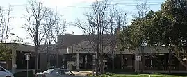 Municipal offices in Horsham | |||||||||||||||
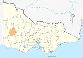 Location in Victoria | |||||||||||||||
| Population | 19,875 (2018)[1] | ||||||||||||||
| • Density | 4.6578/km2 (12.0637/sq mi) | ||||||||||||||
| Established | 1995 | ||||||||||||||
| Gazetted | 20 January 1995[2] | ||||||||||||||
| Area | 4,267 km2 (1,647.5 sq mi)[1] | ||||||||||||||
| Mayor | Cr Robyn Gulline | ||||||||||||||
| Council seat | Horsham | ||||||||||||||
| Region | Grampians | ||||||||||||||
| State electorate(s) | Lowan | ||||||||||||||
| Federal division(s) | Mallee | ||||||||||||||
| Website | Rural City of Horsham | ||||||||||||||
| |||||||||||||||
The Rural City is governed and administered by the Horsham Rural City Council; its seat of local government and administrative centre is located at the council headquarters in Horsham. The Rural City is named after the main urban settlement located in the north-east of the LGA, that is Horsham, which is also the LGA's most populous urban centre with a population of 16,514.[3]
The city was winner of Australia's tidiest town in 2001. There is a shopping precinct that offers coffee shops and restaurants. Horsham is the capital of the region and hosts events from sport to cultural interests. The Horsham golf course is known as country Victoria's best, as awarded from the pro-am circuit. The region is the site of lakes and a Wimmera River system and in normal seasons is popular with fishing, boating, swimming and water enthusiasts.
Traditional owners
There are multiple traditional owners of this land, they are Jaadwa, Jadawadjali, Jupagulk, Wergaia and Wotjobaluk people.[4]
Council
Current composition
The council is composed of seven councillors elected to represent an unsubdivided municipality. The current councillors, in order of election at the 2020 election, are:[5]
| Ward | Party | Councillor | Notes | |
|---|---|---|---|---|
| Unsubdivided | Independent | Penny Flynn | ||
| Independent | Di Bell | |||
| Independent | Robyn Gulline | |||
| Independent | Leslie Power | |||
| Independent | Ian Ross | |||
| Independent | Claudia Haenel | |||
| Independent | David Bowe | |||
Administration and governance
The council meets in the council chambers at the council headquarters in the Horsham Civic Centre, which is also the location of the council's administrative activities. It also provides customer services at its administrative centre in Horsham.
Townships and localities
The 2021 census, the rural city had a population of 20,429 up from 19,642 in the 2016 census[6]
| Population | ||
|---|---|---|
| Locality | 2016 | 2021 |
| Arapiles | * | # |
| Blackheath | * | # |
| Brimpaen^ | 79 | 80 |
| Bungalally | 95 | 93 |
| Clear Lake | 78 | 57 |
| Dadswells Bridge^ | 71 | 69 |
| Dooen | 240 | 250 |
| Douglas^ | 65 | 74 |
| Drung | 147 | 119 |
| Duchembegarra | 38 | 47 |
| Population | ||
|---|---|---|
| Locality | 2016 | 2021 |
| Grass Flat^ | * | # |
| Haven | 1,304 | 1,443 |
| Horsham | 14,543 | 15,134 |
| Jilpander | * | # |
| Jung^ | 241 | # |
| Kalkee | 52 | 48 |
| Kanagulk | 18 | 28 |
| Kewell^ | 48 | 57 |
| Laharum^ | 196 | 162 |
| Longerenong^ | * | 237 |
| Population | ||
|---|---|---|
| Locality | 2016 | 2021 |
| Lower Norton | 231 | 236 |
| McKenzie Creek | 136 | 140 |
| Mitre^ | 69 | 66 |
| Mockinya | 33 | 30 |
| Murra Warra^ | 72 | 63 |
| Natimuk | 514 | 548 |
| Noradjuha | 83 | 89 |
| Nurrabiel | 61 | 43 |
| Pimpinio | 184 | 191 |
| Quantong | 310 | 354 |
| Population | ||
|---|---|---|
| Locality | 2016 | 2021 |
| Riverside | 276 | 287 |
| St Helens Plains | 42 | 40 |
| Telangatuk East | 65 | 75 |
| Tooan | 19 | 23 |
| Toolondo | 59 | 74 |
| Vectis | 179 | 184 |
| Wail | 42 | 44 |
| Wartook^ | 84 | 88 |
| Wonwondah | 103 | 114 |
^ - Territory divided with another LGA
* - Not noted in 2016 Census
# - Not noted in 2021 Census
See also
References
- "3218.0 – Regional Population Growth, Australia, 2017-18: Population Estimates by Local Government Area (ASGS 2018), 2017 to 2018". Australian Bureau of Statistics. Australian Bureau of Statistics. 27 March 2019. Retrieved 25 October 2019. Estimated resident population, 30 June 2018.
- Victoria Government Gazette – Online Archive (1837–1997). "S4 of 1995: Order estg (Part 9) the Rural City of Horsham". State Library of Victoria. State Government of Victoria (published 20 January 1995). p. 4. Retrieved 10 January 2014.
- "3218.0 – Regional Population Growth, Australia, 2017-18: Population Estimates by Significant Urban Area, 2008 to 2018". Australian Bureau of Statistics. Australian Bureau of Statistics. 27 March 2019. Retrieved 25 October 2019. Estimated resident population, 30 June 2018.
- "Acknowledgement of Traditional Owners". www.hrcc.vic.gov.au. Retrieved 28 April 2021.
- "Horsham Rural City Council election results 2020". www.vec.vic.gov.au. Retrieved 13 November 2020.
- "Census | Australian Bureau of Statistics". www.abs.gov.au. 11 January 2023.
External links
- Horsham Rural City Council official website
- Official tourist website for Horsham
- Metlink local public transport map
- Link to Land Victoria interactive maps
Localities in the Rural City of Horsham | ||
|---|---|---|
| Town | 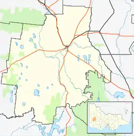 | |
| Locality |
| |
^ - Territory divided with another LGA | ||