Hukanui railway station
The Hukanui railway station on the Wairarapa Line was located in the Tararua District of the Manawatū-Whanganui region in New Zealand’s North Island.
Hukanui railway station | |||||||||||
|---|---|---|---|---|---|---|---|---|---|---|---|
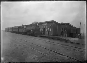
 Hukanui about 1917 | |||||||||||
| General information | |||||||||||
| Location | New Zealand | ||||||||||
| Coordinates | 40.566972°S 175.694450°E | ||||||||||
| Elevation | 195 m (640 ft) | ||||||||||
| Line(s) | Wairarapa Line | ||||||||||
| Distance | Wellington 137.28 km (85.30 mi) | ||||||||||
| History | |||||||||||
| Opened | 9 October 1896 | ||||||||||
| Closed | 1 August 1988 | ||||||||||
| Services | |||||||||||
| |||||||||||
The station served the settlement of Hukanui, which was established in 1894, and was briefly called Brownston.[1] The New Zealand Ministry for Culture and Heritage gives a translation of "heavy snow" for Hukanui.[2]

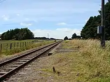
Hukanui in 2008, looking north. Seen here are the loading bank (left, behind the fence) and platform (center)
The station opened on 9 October 1896 and closed on 1 August 1988. It became a siding in January 2009.[3]
The 162-metre (531 ft) bridge across Mangatainoka River, to the south of Hukanui, is the longest on the line.[4]
References
- "Brownston the town its residents wanted to rename (with photo of station site)". Stuff (Fairfax). 9 February 2019.
- "1000 Māori place names". New Zealand Ministry for Culture and Heritage. 6 August 2019.
- "Juliet Scoble: Names & Opening & Closing Dates of Railway Stations in New Zealand" (PDF). Archived from the original (PDF) on 24 July 2020. Retrieved 16 February 2019.
- Geoffrey B. Churchman and Tony Hurst, The Railways of New Zealand: A Journey Through History (Auckland: HarperCollins, 1991), pg. 160.
This article is issued from Wikipedia. The text is licensed under Creative Commons - Attribution - Sharealike. Additional terms may apply for the media files.