Hurlstone Point
Hurlstone point (grid reference SS898492) is a promontory of land between Porlock Weir and Minehead in the Exmoor National Park on the coast of Somerset, England.
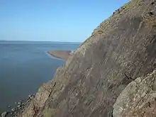
Climbing on Hurlstone Point
Hurlstone Point marks the boundary between Porlock Bay and Blue Anchor Bay in the Bristol Channel and is on the South West Coast Path.[1] There is a coastguard lookout shelter on the point.[2]
The rocks, including a large slab known as "coastguard wall" are popular with climbers.[3]
In 2007 a cyclist was rescued after falling 40 feet (12 m) down the cliff.[4]
References
- "Bossington to Selworthy". Official Guide to the South West Coast Path. Natural England. Retrieved 24 March 2010.
- "Coastguard's lookout at Hurlstone Point, Selworthy, Somerset". Viewfinder National Monuments Record. English Heritage. Archived from the original on 6 June 2011. Retrieved 24 March 2010.
- "Hurlstone point". UK Climbing.com. Archived from the original on 23 February 2005. Retrieved 9 August 2008.
- "Cyclist rescued after cliff fall". BBC News. BBC. 3 May 2007. Retrieved 9 August 2008.
This article is issued from Wikipedia. The text is licensed under Creative Commons - Attribution - Sharealike. Additional terms may apply for the media files.