Hurricane Ana
Hurricane Ana was the second tropical cyclone in 2014 to threaten the U.S. state of Hawaii, after Iselle in August. The twenty-first named storm and fifteenth hurricane of the 2014 Pacific hurricane season, Ana formed from a disturbance that formed in the Central Pacific in mid-October. It rapidly consolidated, and a tropical depression developed by October 13. Aided by favorable conditions, Ana gradually strengthened while moving westward, threatening to pass over the island chain of Hawaii once or several times as indicated by early forecasts. By October 17, it had strengthened to a hurricane south of Hawaii and reached its peak intensity shortly afterwards while also making its closest approach. Afterwards, Ana weakened and began to fluctuate in intensity as it turned to the north and eventually northeast as it rounded a subtropical ridge and interacted with a cold front before becoming a hurricane briefly again on October 25. Ana transitioned into an extratropical cyclone on October 26, and raced across the northwest Pacific before dissipating by October 28 after it came ashore in Western Canada.
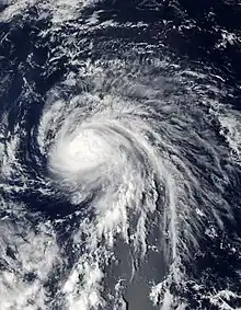
 Ana near peak intensity south of Hawaii on October 17 | |
| Meteorological history | |
|---|---|
| Formed | October 13, 2014 |
| Extratropical | October 26, 2014 |
| Dissipated | October 28, 2014 |
| Category 1 hurricane | |
| 1-minute sustained (SSHWS/NWS) | |
| Highest winds | 85 mph (140 km/h) |
| Lowest pressure | 985 mbar (hPa); 29.09 inHg |
| Overall effects | |
| Fatalities | None |
| Damage | Minimal |
| Areas affected | Hawaii, British Columbia, Alaskan Panhandle |
| IBTrACS | |
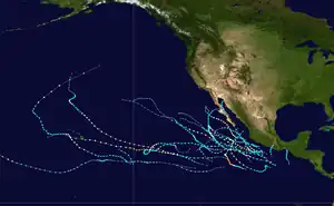
Part of the 2014 Pacific hurricane season | |
Because Ana was originally forecasted to strike the Big Island of Hawaii early in its life, tropical storm watches and eventually warnings were issued in advance of the storm.[1] These were later expanded across nearly the whole island chain as Ana nudged more to the west than forecasted. At its closest approach, Ana dropped heavy rain of nearly up to 11 inches (28 cm), although the heaviest rain missed Hawaii by nearly 20 miles (32 km), averting a potentially dangerous flooding scenario. The swath of tropical storm force winds missed the islands as well, minimizing damage by a great deal.[1]
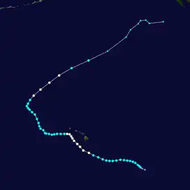
Meteorological history

Tropical storm (39–73 mph, 63–118 km/h)
Category 1 (74–95 mph, 119–153 km/h)
Category 2 (96–110 mph, 154–177 km/h)
Category 3 (111–129 mph, 178–208 km/h)
Category 4 (130–156 mph, 209–251 km/h)
Category 5 (≥157 mph, ≥252 km/h)
Unknown
In mid-October 2014, disorganized but deep convection persisted in the Central Pacific at low latitudes. By October 12, the Central Pacific Hurricane Center (CPHC) noted the potential for tropical cyclogenesis in the vicinity of the convection.[1] Over the next day, rapid organization occurred as an area of low pressure formed and convection became significantly better organized. Based on this, advisories were issued on Tropical Depression Two-C at 21:00 UTC. Further organization continued within the system and the cyclone was eventually upgraded to Tropical Storm Ana by the next day.[1]
A cold front that had been passing through the Central Pacific had begun to weaken a subtropical ridge to Ana's north, which allowed it to gain latitude as it moved west due to deep steering flow.[1] Under a favorable environment with above-normal sea surface temperatures, Ana gradually intensified as it tracked northwest towards Hawaii, eventually become a hurricane by 21:00 UTC on October 17, shortly before reaching peak intensity nine hours later at 06:00 UTC on October 18 about 120 miles (190 km) southwest of the Big Island.[1] Ana began to curve westwards, and weakening began to ensue shortly afterwards, and fell below hurricane intensity by 06:00 UTC on October 20.
Ana continued to track westwards away from the Hawaiian islands, until it reached the western periphery of the subtropical ridge and as a cold front began to extend towards it.[1] At this point, Ana had weakened to a minimal tropical storm. As it turned northeast, warm sea surface temperatures caused Ana to rapidly reorganize and strengthen, and by 03:00 UTC on October 25, Ana became a hurricane again, with a cloud-filled eye developing aside other structural improvements.[1] As it accelerated northeast at speeds of 40 mph (64 km/h), Ana succumbed to the wind shear and weakened again to a tropical storm. By 15:00 UTC on October 26, Ana had transitioned into an extratropical cyclone.[1] According to the CPHC, this made Ana the longest-lived and longest-tracked tropical cyclone that stayed entirely within the Central Pacific basin.[1] Ana's extratropical remnant continued to race northeastward across the Pacific Ocean, before making landfall in British Columbia, dissipating afterward on October 28.[1]
Preparations and impact

Beginning on October 15, various tropical cyclone warnings and watches were issued for Hawaii, starting with a tropical storm watch for the Big Island.[2] Three days later, a tropical storm warning was issued for Kauai and Niihau,[3] and was extended to include portions of the Papahānaumokuākea Marine National Monument.[4] The threat of the storm forced parks and beaches to close in the state.[5] While passing south of Hawaii, Ana produced heavy rainfall on most of the islands, peaking at 11.67 in (296 mm) at Keaumo on the Big Island.[6] The rains caused the Sand Island water treatment plant in Honolulu to overflow, which sent about 5,000 gallons of partially treated wastewater into Honolulu Harbor.[7]
.jpg.webp)
Although no real-time wind reports of damage from Ana was reported on the Big Island, a post-storm report in November 2014 by resident Keith Robinson reported that there was damage in the southern vicinity of Niihau.[1] He reported extensive vegetation damage as well as tree tops levelled at "an estimated Beaufort Wind Scale range of 40–50 mph (64–80 km/h)". Although it was not officially verified, the CPHC decided to treat the report as part of the conditions experienced in the area that was under a tropical storm warning.[1]
References
- Jeff Powell (July 17, 2015). Hurricane Ana (PDF) (Report). Central Pacific Hurricane Center. Retrieved June 9, 2019.
- Kodama (October 15, 2014). "Tropical Storm Ana Advisory Number 10". Central Pacific Hurricane Center. Retrieved October 21, 2014.
- Wroe (October 18, 2014). "Hurricane Ana Advisory Number 22". Central Pacific Hurricane Center. Retrieved October 21, 2014.
- Powell (October 19, 2014). "Hurricane Ana Advisory Number 25". Central Pacific Hurricane Center. Retrieved October 21, 2014.
- Kurtis Lee (October 19, 2014). "Hurricane Ana weakens, moves west of Hawaii". Los Angeles Times. Retrieved October 21, 2014.
- "Hurricane Ana Rainfall Totals". Honolulu, Hawaii National Weather Service. October 19, 2014. Archived from the original on October 24, 2014.
- Jim Mendoza (October 21, 2014). "Hurricane triggers sewage spill". WWLP.com. Archived from the original on October 21, 2014. Retrieved October 21, 2014.
External links
- The CPHC's Tropical Cyclone Report on Ana
- The CPHC's tropical cyclone advisory archive on Ana Archived 2018-09-03 at the Wayback Machine
