Hurricane Kilo
Hurricane Kilo, also referred to as Typhoon Kilo, was a long-lived tropical cyclone that traveled more than 4,000 miles (6,400 kilometers) from its formation point southeast of the Hawaiian Islands to its dissipation point northeast of Japan. Kilo affected areas from Hawaii to the Russian Far East along its long track in August and September 2015. Kilo was the third of a record nine named storms to develop in the North Central Pacific tropical cyclone basin during the 2015 Pacific hurricane season.
| Typhoon (JMA scale) | |
|---|---|
| Category 4 typhoon (SSHWS) | |
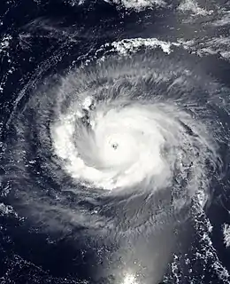 Hurricane Kilo rapidly strengthening over the central Pacific on August 29 | |
| Formed | August 22, 2015 |
| Dissipated | September 15, 2015 |
| (Extratropical after September 11) | |
| Highest winds | 10-minute sustained: 150 km/h (90 mph) 1-minute sustained: 220 km/h (140 mph) |
| Lowest pressure | 940 hPa (mbar); 27.76 inHg |
| Fatalities | None reported |
| Damage | Minimal |
| Areas affected | Hawaii, Johnston Atoll, Japan, Russian Far East |
| Part of the 2015 Pacific hurricane and typhoon seasons | |
Kilo formed from a tropical disturbance that was first identified by the National Hurricane Center (NHC) on August 17, about 1,150 mi (1,850 km) southeast of the Big Island of Hawaii. Initially, a mid-level ridge to the disturbance's east imparted easterly wind shear over the system, preventing it from organizing. Eventually, the shear decreased and the disturbance became a tropical depression on August 22. The wind shear decreased further on August 26, and the depression intensified into Tropical Storm Kilo at 18:00 UTC that day while approaching Johnston Atoll. Amid high sea surface temperatures and low vertical wind shear, Kilo began to quickly strengthen while being steered westwards by a mid-level ridge, attaining hurricane status on August 29. Over the next 24 hours, Kilo rapidly intensified into a Category 4 hurricane, with its winds nearly doubling from 75 mph (120 km/h) to 140 mph (220 km/h). Kilo reached its peak intensity at the end of this strengthening phase, with a central pressure of 940 mbar (hPa; 27.76 inHg). Around this time, Kilo was one of three hurricanes at Category 4 intensity spanning the Eastern and Central Pacific basins, the first such occurrence in recorded history. On September 1, Kilo crossed the International Date Line and became a typhoon. Kilo progressed westward over the open ocean as a typhoon in the Western Pacific for over a week while fluctuating in intensity. Kilo continued on as a tropical cyclone until September 11, when it curved northeastwards near Japan and became an extratropical cyclone near the western Kuril Islands of Russia. Kilo's extratropical remnant continued northeastward until dissipating over the Russian Far East on September 15.
As a tropical depression, Kilo brought heavy rain and flash flooding to all of the Hawaiian island chain. Flash flood watches and warnings were issued for the state. Many roads were impassable after Kilo's rainbands dropped several inches of rain. Honolulu set a daily rainfall record for the month August on August 24, with 3.53 in (90 mm) recorded. Sewers overflowed in Ala Moana, and thousands of gallons of wastewater swept onto streets. Despite the severe flooding, damage in Hawaii was minor. A tropical storm warning was issued for Johnston Atoll as Kilo passed closely to the north, though the hurricane passed the territory without leaving any damage.
Meteorological history
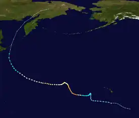
Tropical storm (39–73 mph, 63–118 km/h)
Category 1 (74–95 mph, 119–153 km/h)
Category 2 (96–110 mph, 154–177 km/h)
Category 3 (111–129 mph, 178–208 km/h)
Category 4 (130–156 mph, 209–251 km/h)
Category 5 (≥157 mph, ≥252 km/h)
Unknown
Origins and passing near Johnston Atoll
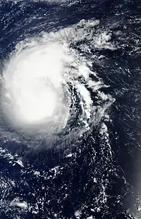
The tropical disturbance that would become Kilo first developed on August 17, about 1,150 mi (1,850 km) southeast of the Big Island of Hawaii, within a broad, low-level trough. The disturbance began to move slowly northeast out of the trough on August 19 while remaining poorly organized, producing intermittent bursts of convection. Steered to the northwest by a mid-level ridge to its northeast that produced easterly wind shear over the system, it initially remained poorly organized. However, a brief surge in convection and weak low-level circulation center (LLCC) developed over the system on August 20, though the two features separated later that day. As a ridge to the disturbance's north steered it more quickly to the west-northwest, wind shear relaxed over the system, allowing its LLCC to re-consolidate. The disturbance developed into a tropical depression by 6:00 UTC on August 22.[1][lower-alpha 1]
The newly-formed depression continued to the west-northwest over the following days, initially hindered by continued easterly shear. The storm turned more northward on August 24 and slowed as it neared the edge of the ridge. The slow-moving storm gradually became more organized as a new ridge strengthened to its northwest, and wind shear began to lessen. Turning southwestwards, the depression strengthened into Tropical Storm Kilo at 18:00 UTC[lower-alpha 2] on August 26 as it drifted towards Johnston Atoll. Kilo continued to intensify as it moved southwestwards, passing northwest of the territory as a strong tropical storm. Turning west under the influence of another ridge to its north, Kilo achieved hurricane status at 6:00 UTC on August 29.[1][2]
Rapid intensification and peak intensity
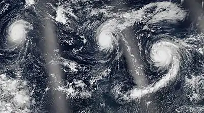
Kilo was situated within an environment of warm waters and low vertical wind shear when it reached hurricane status. Within these favorable environmental conditions, the storm began a significant bout of rapid intensification. In a 12-hour period from 6:00 to 18:00 UTC on August 29, Kilo intensified from a low-end, 75 mph (120 km/h) Category 1 hurricane to a high-end, 125 mph (200 km/h) Category 3 major hurricane. The hurricane continued to intensify as it turned more west-northwestward, and the cyclone achieved peak intensity as a powerful Category 4 hurricane at 6:00 UTC on August 30, with maximum sustained winds of 140 mph (225 km/h) and a minimum barometric pressure of 940 mbar (28 inHg).[1] Kilo weakened slightly later that day, though its intensity plateaued at 125 mph (200 km/h) by August 31. A break in the mid-level ridge steering Kilo allowed it to turn northward as it approached the International Dateline. By 18:00 UTC, Kilo had crossed the dateline and entered the Western Pacific basin, at which time it was re-classified as a typhoon.[1][2]
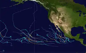
While Kilo was traversing the Central Pacific as a major hurricane, hurricanes Ignacio and Jimena were also active as Category 4 hurricanes. This marked the first time on record that three concurrent major hurricanes were active east of the International Date Line, as well as the first time three Category 4 hurricanes were simultaneously active in the Eastern/Central Pacific. Additionally, Ignacio was active within the Central Pacific basin alongside Kilo, marking the first time two simultaneous major hurricanes were active within the Central Pacific. Kilo also became the third tropical cyclone of the 2015 season to cross the Date Line, surpassing the previous mark of two crossing the dateline in 1997.[1]
Transition into a typhoon, weakening and demise

Kilo began to weaken as it crossed into the Western Pacific, encountering cooler waters and higher wind shear. The storm weakened to a Category 2-equivalent typhoon on September 1 as it entered the basin. Kilo maintained its intensity for another day as its motion slowed and the storm turned westward. Late on September 3, Kilo turned to the southwest again, and underwent another brief weakening trend, bottoming out as an 85 mph (135 km/h), Category 1-equivalent typhoon on September 5, due to increased southwesterly wind shear.[3] Kilo turned westward around this time, along the Tropic of Cancer, and began a new intensification phase on September 6. The storm reached its secondary peak intensity by 00:00 UTC on September 7, with maximum sustained winds of 105 mph (170 km/h), near the intersection of the Tropic of Cancer and the 170th meridian east.[2][4] Kilo began to weaken again later that day as its eye became irregularly shaped, and convection eroded over the southern semicircle of the storm.[5]
Embarking on a more northwestward course that day, the storm began another weakening phase as it was steered by a ridge to its north. Deep convection associated with Kilo decreased in intensity and coverage through September 8 as drier air wrapped into the core of the typhoon.[6] Kilo only weakened gradually, however, with its winds slowly diminishing to severe-tropical-storm-force by 12:00 UTC on September 9, as its center became exposed from its convective activity within an environment of even stronger shear.[7][8] Kilo accelerated northwestward, with a gradual northward bend as it became caught up in the middle latitude westerlies east of Japan. The storm flat-lined in intensity on September 10 as it passed the country, bending further in direction and turning to the northeast as it began to undergo extratropical transition.[9] Kilo then resumed weakening on September 11, before transitioning to an extratropical cyclone at 12:00 UTC that day, near the Kuril Islands of Russia,[2] over 4,000 mi (6,400 km) from its genesis point.[1] Kilo also slightly strengthened as it became extratropical, with winds of 60 mph (95 km/h).[4] Kilo's extratropical remnant continued to race northeastward, crossing into the Sea of Okhotsk on September 12 before dissipating over the Russian Far East on September 15.[2]
Preparations and impact
A flash flood watch was issued by the National Weather Service for all Hawaiian islands, ending at 6:00 p.m. HST on August 24. The weather service also issued a Marine Weather Statement for heavy showers and thunderstorms.[10]
Moisture associated with Kilo, then a tropical depression, affected Hawaii. Honolulu received 4.48 in (114 mm) of rain from early on August 23 to August 25, including 3.53 inches (90 mm) on August 24, setting a record for the highest rainfall amount for any day in August. Rain rates of 3 to 4 inches (76 to 102 mm) per hour were estimated by radar near Kauai. Thunderstorms over the island chain produced up to an estimated 10,000 cloud-to-ground lightning strikes over a 24-hour period from August 23 to 24.[11] A flash flood warning was issued on August 23 for the Big Island.[10] Kohala Mountain Road on the Big Island was closed after water covered its surface.[12] Floodwaters made the Piilani Highway in Maui impassable.[13] In Kipahulu, the Hana Highway flooded, cutting off parts of the town.[14] Numerous schools closed near the Hana area, where the Hana Highway was closed for several miles across.[15] Inundation forced the closures of the Waiʻanapanapa and Iao Valley state parks.[16][17] The towns of Kahana and Honokowai reported neighborhoods being flooded.[18] In Oahu, flash floods inundated areas near the Ala Moana Center and a flooded a Walmart.[19] More than a foot of water flooded roads in Ala Moana.[20] In that town, the sewer system failed during the floods, with thousands of gallons of sewer water flowing out of manholes.[21] An off-ramp of Interstate H-1 near the University of Hawaii was impassable.[22] In addition, two lanes of the highway near Waimalu were flooded and closed.[23] Several schools on Oahu closed on August 24 due to floods and power outages.[24]
At 21:00 UTC on August 23, a Tropical Storm Watch was issued for Johnston Atoll. The watch was upgraded to a Tropical Storm Warning at 03:00 UTC the next day. The warning was cancelled on August 25 as the threat of tropical storm-force sustained winds diminished. The U.S. Fish and Wildlife Service stationed personnel on the atoll as Kilo passed within 35 mi (55 km) to the north.[1]
See also
- Tropical cyclones in 2015
- List of Category 4 Pacific hurricanes
- Hurricane John (1994) – Furthest-travelling tropical cyclone on record, also crossed International Dateline and became a typhoon
- Hurricane Ioke (2006) - Had a similar track, also crossed Dateline and became a typhoon
- Hurricane Genevieve (2014) – Also crossed over the International Dateline and became a typhoon
- Hurricane Hector (2018) – long-lasting Category 4 hurricane that affected Hawaii and had a similar track
Notes
- Kilo was operationally thought to have developed and reached tropical storm strength on August 20, when its LLCC initially formed. Thus, it received a name before Hurricane Loke, which formed a day earlier.
- All times are in Coordinated Universal Time, unless otherwise noted.
References
- Thomas Birchard (October 10, 2018). Hurricane Kilo (PDF) (Report). Tropical Cyclone Report. Honolulu, Hawaii: Central Pacific Hurricane Center. Retrieved June 9, 2019.
- Sopko, Steven P.; Falvey, Robert J. Annual Tropical Cyclone Report 2015 (PDF) (Report). Honolulu, Hawaii: Joint Typhoon Warning Center. Retrieved October 19, 2023.
- "Prognostic Reasoning for Typhoon 03C (Kilo) Warning Nr 59". Joint Typhoon Warning Center. Archived from the original on September 4, 2015. Retrieved October 21, 2023.
- TC Realtime CP032015 - Major Hurricane KILO (Report). Fort Collins, Colorado: Regional and Mesoscale Meteorology Branch. Retrieved October 20, 2023.
- "Prognostic Reasoning for Typhoon 03C (Kilo) Warning Nr 59". Joint Typhoon Warning Center. Archived from the original on September 4, 2015. Retrieved October 21, 2023.
- "Prognostic Reasoning for Typhoon 03C (Kilo) Warning Nr 77". Joint Typhoon Warning Center. Archived from the original on September 9, 2015. Retrieved October 21, 2023.
- "Prognostic Reasoning for Typhoon 03C (Kilo) Warning Nr 81". Joint Typhoon Warning Center. Archived from the original on September 10, 2015. Retrieved October 21, 2023.
- "Prognostic Reasoning for Tropical Storm 03C (Kilo) Warning Nr 84". Joint Typhoon Warning Center. Archived from the original on September 10, 2015. Retrieved October 21, 2023.
- "Prognostic Reasoning for Tropical Storm 03C (Kilo) Warning Nr 85". Joint Typhoon Warning Center. Archived from the original on September 10, 2015. Retrieved October 21, 2023.
- "Flash flood warning, watch and marine advisories for Hawaii". Hawaii247. August 23, 2015. Retrieved January 11, 2021.
- "Kilo Became Three Weeks Old Before Dissipating". The Weather Channel. September 11, 2015. Retrieved January 11, 2021.
- Event: Flash Flood in Hawaii County, Hawaii (Report). National Centers for Environmental Information. August 23, 2015. Retrieved January 11, 2021.
- Event: Flash Flood in Maui County, Hawaii (Report). National Centers for Environmental Information. August 23, 2015. Retrieved January 11, 2021.
- Event: Flash Flood in Maui County, Hawaii (Report). National Centers for Environmental Information. August 24, 2015. Retrieved January 11, 2021.
- Event: Flash Flood in Maui County, Hawaii (Report). National Centers for Environmental Information. August 24, 2015. Retrieved January 11, 2021.
- Event: Flash Flood in Maui County, Hawaii (Report). National Centers for Environmental Information. August 24, 2015. Retrieved January 11, 2021.
- Event: Flash Flood in Maui County, Hawaii (Report). National Centers for Environmental Information. August 24, 2015. Retrieved January 11, 2021.
- Event: Flash Flood in Maui County, Hawaii (Report). National Centers for Environmental Information. August 25, 2015. Retrieved January 11, 2021.
- Event: Flash Flood in Honolulu County, Hawaii (Report). National Centers for Environmental Information. August 24, 2015. Retrieved January 11, 2021.
- Event: Flash Flood in Honolulu County, Hawaii (Report). National Centers for Environmental Information. August 24, 2015. Retrieved January 11, 2021.
- Event: Flash Flood in Honolulu County, Hawaii (Report). National Centers for Environmental Information. August 24, 2015. Retrieved January 11, 2021.
- Event: Flash Flood in Honolulu County, Hawaii (Report). National Centers for Environmental Information. August 24, 2015. Retrieved January 11, 2021.
- Event: Flash Flood in Honolulu County, Hawaii (Report). National Centers for Environmental Information. August 24, 2015. Retrieved January 11, 2021.
- Event: Flash Flood in Honolulu County, Hawaii (Report). National Centers for Environmental Information. August 24, 2015. Retrieved January 11, 2021.
![]() This article incorporates public domain material from websites or documents of the National Weather Service.
This article incorporates public domain material from websites or documents of the National Weather Service.
