Indian River (Delaware)
The Indian River is a river and estuary, approximately 15 mi (24 km) long, in Sussex County in southern Delaware in the United States.[1] The river is named after a Native American reservation that was located on its upper reaches.

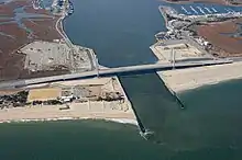
The Indian River rises approximately 2 miles (3.2 km) southwest of Georgetown and flows east, past Millsboro, its head of navigation. It enters Indian River Bay, an inlet of the Atlantic Ocean south of Cape Henlopen. The lower 6 miles (9.7 km) of the river form a navigable tidal estuary stretching westward from Indian River Bay, which is protected from the open ocean by two sand bar peninsulas. East of the bay is its mouth, the Indian River Inlet.[2] Until 1928, the Indian River Inlet was a natural waterway that shifted up and down a two-mile (3.2 km) stretch of the coast. Dredging kept the inlet open in its current location between 1928 and 1937, and in 1938 the United States Army Corps of Engineers built jetties that hold it in place.[3]

Roads cross the river in three places, at U.S. Route 113 (in Millsboro), Delaware Route 24/Delaware Route 30 (also in Millsboro), and Delaware Route 1 (at Indian River Inlet in the Delaware Seashore State Park). With the Indian River Inlet in a fixed place beginning in 1928, it became possible to build a bridge to span it, and the completion of the Ocean Highway (present-day Delaware Route 1 and now known as Coastal Highway) between Rehoboth Beach and Bethany Beach in 1933 prompted Delaware to build a span to connect the northern and southern segments of the highway. Since 1934, six bridges have spanned the inlet, all known informally as the Indian River Inlet Bridge, although all but the first officially were named the Charles W. Cullen Bridge.[3] The current Indian River Inlet Bridge opened in 2012.[4]
See also
References
- "Indian River". Geographic Names Information System. United States Geological Survey, United States Department of the Interior. Retrieved 2 April 2011.
- "Indian River Inlet". Geographic Names Information System. United States Geological Survey, United States Department of the Interior. Retrieved 2 April 2011.
- Titus, M. Patricia, "Ball now in state’s court on IR Inlet Bridge," Coastal Point, undated.
- Murray, Molly (21 Jan 2012), "First lane of new Indian River Inlet bridge opens", The News Journal, delawareonline, retrieved 21 Jan 2012