Integrated Marine and Coastal Regionalisation of Australia
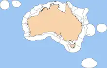
The Integrated Marine and Coastal Regionalisation of Australia (IMCRA), formerly the Interim Marine and Coastal Regionalisation for Australia, is a biogeographic regionalisation of the oceanic waters of Australia's exclusive economic zone (EEZ). As of 2008, the most recent version is IMCRA Version 4.0.[1][2]
IMCRA actually defines two bioregionalisations: a benthic bioregionalisation, based on biogeography of fish together with geophysical data; and a pelagic bioregionalisation, base on oceanographic characteristics.[2]
The benthic bioregionalisation incorporates three separate regionalisations:[2]
- A regionalisation of the EEZ into provincial bioregions, based on the biogeography of bottom dwelling fishes. In IMCRA 4.0, 41 provincial bioregions, consisting of 24 provinces and 17 transitions.
- A regionalisation of the continental shelf into meso-scale regions based on biological and physical characters, and the distance from the coast. In IMCRA 4.0 there are 60 meso-scale regions.
- A regionalisation of the EEZ into 14 geomorphic units, formed by grouping the 1,134 geomorphic units defined by Geoscience Australia.
The pelagic bioregionalisation divides the continental shelf into four provincial bioregions based on pelagic fish species biodiversity and richness. Offshore waters are divided into three-dimensional water masses, taking into account water properties, circulation patterns and energetics.[2]
List of provincial bioregions
This is a list of IMCRA 4.0 provincial bioregions:[3]
| Bioregion | information | IMCRA meso-scale bioregions | Marine Ecoregions of the World designation |
|---|---|---|---|
| Bass Strait Shelf Province | cold temperate waters | Central Victoria (CV) Victoria Embayment (VE), Central Bass Strait (CBS), Boags (BGS) | Bassian (205) |
| Cape Province | na | na | |
| Central Eastern Shelf Province | warm temperate waters | Manning Shelf (MAN), Hawkesbury Shelf (HAW) | Manning-Hawkesbury (203) |
| Central Eastern Shelf Transition | transition between the tropical Northeast Shelf and warm-temperate Central Eastern Shelf provinces | Tweed-Moreton (TM) | Tweed-Moreton (202) |
| Central Eastern Province | na | na | |
| Central Eastern Transition | na | na | |
| Central Western Shelf Province | subtropical waters | Shark Bay (SBY), Zuytdorp (ZUY) | Shark Bay (210) |
| Central Western Shelf Transition | transition | Ningaloo (NIN) | Ningaloo (145) |
| Central Western Province | subtropical waters | na | na |
| Central Western Transition | na | na | |
| Christmas Island Province | tropical waters | Cocos-Keeling/Christmas Island (120) | |
| Cocos (Keeling) Island Province | tropical waters | Cocos-Keeling/Christmas Island (120) | |
| Great Australian Bight Shelf Transition | transition between the warm-temperate Southwest Shelf and Spencer Gulf Shelf provinces | Eucla (EUC), Murat (MUR) | Great Australian Bight (208) |
| Kenn Province | tropical waters | na | na |
| Kenn Transition | |||
| Lord Howe Province | warm temperate waters | Lord Howe and Norfolk Islands (151) | |
| Macquarie Island Province | cold temperate waters | Macquarie Island (212) | |
| Norfolk Island Province | warm temperate waters | Lord Howe and Norfolk Islands (151) | |
| Northeast Shelf Province | tropical waters | West Tropic Coast (WTC), Central Reef (CR), Lucinda-Mackay Coast (LMC), Shoalwater Coast (SC), Mackay-Capricorn (MC), Pompey-Swains (PS) | Central and Southern Great Barrier Reef (143) |
| Northeast Shelf Transition | transition between the tropical Northern Shelf and Northeast Shelf provinces | Torres Strait (TS), East Cape York (ECY), Ribbons (RBN) | Torres Strait and Northern Great Barrier Reef (142) |
| Northeast Province | tropical waters | na | na |
| Northeast Transition | na | na | |
| Northern Shelf Province | tropical waters | Van Diemens Gulf (VDG), Cobourg (COB), Arafura (ARA), Arnhem Wessel (AWS), Carpentaria (CAR), Groote (GRO), Pellew (PEL), Wellesley (WLY), Karumba-Nassau (KAN), West Cape York (WCY) | Arnhem Coast to Gulf of Carpentaria (140) |
| Northwest Province | tropical waters | na | na |
| Northwest Shelf Province | tropical waters | Pilbara (nearshore) (PIN), Pilbara (offshore) (PIO), Eighty Mile Beach (EMB), Canning (CAN), North West Shelf (NWS) | Exmouth to Broome (144) |
| Northwest Shelf Transition | transition between the tropical Northern Shelf and Northwest Shelf provinces | Kimberley (KIM), King Sound (KSD), Anson Beagle (ANB), Cambridge-Bonaparte (CAB), Bonaparte Gulf (BON), Tiwi (TWI) | Bonaparte Coast (141) |
| Northwest Transition | na | na | |
| Southeast Shelf Transition | transition between the warm-temperate Central Eastern Shelf and the cold-temperate Bass Strait Shelf provinces | Batemans Shelf (BAT), Flinders (FLI), Twofold Shelf (TWO) | Cape Howe (204) |
| Southeast Transition | na | na | |
| Southern Province | warm temperate waters | na | na |
| Southwest Shelf Province | warm temperate waters | Leeuwin–Naturaliste (LNE), Western Australia South Coast (WSC) | Leeuwin (209) |
| Southwest Shelf Transition | transition between the subtropical Central West Province and the warm temperate Southwest Shelf Province | Abrolhos Islands (ABR) and Central West Coast (CWC) | Houtman (211) |
| Southwest Transition | na | na | |
| Spencer Gulf Shelf Province | warm temperate waters | Coorong (COR), Eyre (EYR), North Spencer Gulf (NSG), St Vincent Gulf (SVG), Spencer Gulf (SG) | South Australian Gulfs (207) |
| Tasmania Province | cold temperate waters | na | na |
| Tasmanian Shelf Province | cold temperate waters | Bruny (BRU), Davey (DAV), Franklin (FRA), Freycinet (FRT) | Bassian (205) |
| Timor Province | tropical waters | na | na |
| Timor Transition | na | na | |
| West Tasmania Transition | na | na | |
| Western Bass Strait Shelf Transition | transition between the cold-temperate Bass Strait Shelf and Tasmanian Shelf provinces and the warm-temperate Spencer Gulf Shelf Province | Otway (OTW) | Western Bassian (206) |
List of Benthic meso-scale regions
|
|
|
Geomorphic units
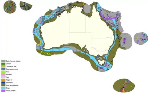
There are 1,334 separate geomorphic units in Australia’s waters, in 14 categories. The regions represent distinct areas of geomorphic features that have similar characteristics (e.g. areas of the continental slope that contain canyons, or flat plains).[2]
Geomorphic features are determined by bathymetric models (depth analysis) of the ocean floor and provide an important predictor of species assemblages at a large scale. For example, different species will occur on low-gradient terraces compared to those on the steep-walled submarine canyons.[4]
Categories
Nomenclature of geomorphic features are based on definitions endorsed by the International Hydrographic Organization (IHO, 2001).[5]
- Apron:
Gently dipping featureless surface, underlain primarily by sediment, at the base of any steeper slope. - Bank, sandbank:
Shallow water or submerged bank of sand in a sea or river that may be exposed at low tide - Basin; terrace; plateau:
Depression, characteristically in the deep sea floor, more or less equidimensional in plan and of variable extent;
Relatively flat horizontal or gently inclined surface, sometimes long and narrow, which is bounded by a steeper ascending slope on one side and by a steeper descending slope on the opposite side;
Flat or nearly flat area of considerable extent, dropping off abruptly on one or more sides. - Canyon:
A relatively narrow, deep depression with steep sides, the bottom of which generally has a continuous slope, developed characteristically on some continental slopes. - Continental rise
- Deep; escarpment:
Generally depths greater than 6,000 m; Elongated and comparatively steep slope separating or gently sloping areas. - Knoll:
Relatively small isolated elevation of a rounded shape. - Pinnacle:
High tower or spire-shaped pillar of rock or coral, alone or cresting a summit. It may extend above the surface of the water. It may or may not be a hazard to surface navigation - Reef:
Rock lying at or near the sea surface that may constitute a hazard to surface navigation - Ridge; sill:
(a) Long, narrow elevation with steep sides. (b) Long, narrow elevation often separating ocean basins. (c) Linked major mid-oceanic mountain systems of global extent;
Sea floor barrier of relatively shallow depth restricting water movement between basins. - Seamount:
Large isolated elevation, greater than 1000 m in relief above the sea floor, characteristically of conical form. - Shelf; abyssal plain:
A gently sloping, flatter region adjacent to a continent (or around an island) or at abyssal depths. - Slope:
A sloped area seaward from the shelf edge to the upper edge of a continental rise or the point where there is a general reduction in slope. - Trench; saddle:
Long narrow, characteristically very deep and asymmetrical depression of the sea floor, with relatively steep sides;
Broad pass, resembling in shape a riding saddle, in a ridge or between contiguous seamounts.
External links
References
- IMCRA Technical Group. "Interim Marine and Coastal Regionalisation for Australia: an ecosystem-based classification for marine and coastal environments". Environment Australia, Department of the Environment, Australian Government. Retrieved 23 December 2013.
- "A guide to the Integrated Marine and Coastal Biogeographic Regionalisation of Australia: IMCRA Version 4.0: June 2006". Department of the Environment, Australian Government. Retrieved 23 December 2013.
- IMCRA 4.0 data
- "Benthic Marine Bioregionalisation of Australia's Exclusive Economic Zone". environment.gov.au. Government of Australia. 2005. Retrieved 16 July 2017.
- "Geomorphic features of the continental margin of Australia". environment.gov.au. Commonwealth of Australia. 2005. Retrieved 16 July 2017.