Irabu Island
Irabu Island (伊良部島, Irabu-jima) (Miyako: Irav), is an island in Miyakojima, Okinawa Prefecture, Japan. The island is connected to Miyako Island by a 3,540-metre-long (11,610 ft) bridge Irabu Ohashi (伊良部大橋),[1] which was completed in January 2015.[2] Irabu Island is also connected via six bridges to Shimoji-shima.[1] There are multiple language variants spoken on the island: Nakachi-Irabu, Kuninaka, Sawada-Nakahama, and Sarahama (which is a variant of Ikema language spoken by descendants of emigrants from Ikema Island).[3]
Native name: Irabu-jima (伊良部島) | |
|---|---|
 Irabu Island is to the west of Miyako Island | |
| Geography | |
| Location | Okinawa Prefecture |
| Coordinates | 24°50′20″N 125°9′56″E |
| Archipelago | Miyako Islands |
| Adjacent to | East China Sea |
| Area | 29.06 km2 (11.22 sq mi)[1] |
| Highest elevation | 89.0 m (292 ft) |
| Administration | |
| Prefecture | Okinawa Prefecture |
| Demographics | |
| Population | 4,693 (2015 national census)[1] |
| Ethnic groups | Ryukyuan, Japanese |
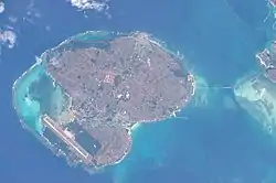
Irabu Island is in the center, Shimoji Island below, and the Irabu Bridge to the right
Climate
| Climate data for Irabu (1981−2010 normals, extremes 1978−2009) | |||||||||||||
|---|---|---|---|---|---|---|---|---|---|---|---|---|---|
| Month | Jan | Feb | Mar | Apr | May | Jun | Jul | Aug | Sep | Oct | Nov | Dec | Year |
| Record high °C (°F) | 27.8 (82.0) |
27.5 (81.5) |
29.5 (85.1) |
30.2 (86.4) |
32.2 (90.0) |
33.8 (92.8) |
35.0 (95.0) |
35.1 (95.2) |
33.9 (93.0) |
31.8 (89.2) |
31.2 (88.2) |
28.9 (84.0) |
35.1 (95.2) |
| Average high °C (°F) | 20.2 (68.4) |
20.6 (69.1) |
22.4 (72.3) |
24.9 (76.8) |
27.4 (81.3) |
29.8 (85.6) |
31.7 (89.1) |
31.2 (88.2) |
30.0 (86.0) |
27.8 (82.0) |
24.9 (76.8) |
21.7 (71.1) |
26.1 (78.9) |
| Daily mean °C (°F) | 17.8 (64.0) |
18.1 (64.6) |
19.8 (67.6) |
22.3 (72.1) |
24.7 (76.5) |
27.2 (81.0) |
28.8 (83.8) |
28.3 (82.9) |
27.2 (81.0) |
25.2 (77.4) |
22.5 (72.5) |
19.5 (67.1) |
23.5 (74.2) |
| Average low °C (°F) | 15.5 (59.9) |
15.8 (60.4) |
17.2 (63.0) |
19.9 (67.8) |
22.3 (72.1) |
25.1 (77.2) |
26.4 (79.5) |
25.9 (78.6) |
24.8 (76.6) |
23.1 (73.6) |
20.5 (68.9) |
17.3 (63.1) |
21.2 (70.1) |
| Record low °C (°F) | 6.9 (44.4) |
6.3 (43.3) |
5.1 (41.2) |
10.0 (50.0) |
14.3 (57.7) |
16.3 (61.3) |
22.0 (71.6) |
21.5 (70.7) |
17.5 (63.5) |
16.7 (62.1) |
10.0 (50.0) |
6.4 (43.5) |
5.1 (41.2) |
| Average precipitation mm (inches) | 116.9 (4.60) |
122.4 (4.82) |
128.6 (5.06) |
152.1 (5.99) |
184.6 (7.27) |
174.3 (6.86) |
102.4 (4.03) |
208.0 (8.19) |
194.6 (7.66) |
129.6 (5.10) |
116.1 (4.57) |
129.0 (5.08) |
1,758.4 (69.23) |
| Average precipitation days (≥ 1.0 mm) | 12.9 | 11.7 | 12.9 | 10.2 | 10.7 | 10.4 | 9.2 | 12.3 | 11.9 | 9.2 | 11.1 | 10.5 | 133 |
| Mean monthly sunshine hours | 93.9 | 94.6 | 125.0 | 127.8 | 130.0 | 150.7 | 208.1 | 210.6 | 189.2 | 170.3 | 128.3 | 111.5 | 1,740 |
| Source: JMA[4][5] | |||||||||||||
See also
References
- "Remote island related materials (離 島 関 係 資 料)" (PDF). Archived (PDF) from the original on 15 February 2020. Retrieved 15 February 2020.
- "伊良部島", Retrieved on 13 January 2018.
- Heinrich, Patrick; Miyara, Shinsho; Shimoji, Michinori (17 February 2015). Handbook of the Ryukyuan Languages: History, Structure, and Use. Walter de Gruyter. pp. 405–406. ISBN 9781614511151.
- 観測史上1~10位の値(年間を通じての値). JMA. Retrieved 24 February 2022.
- 過去の気象データ検索. JMA. Retrieved 24 February 2022.
| Core city | ||
|---|---|---|
| Cities | ||
| Districts | ||
This article is issued from Wikipedia. The text is licensed under Creative Commons - Attribution - Sharealike. Additional terms may apply for the media files.