Litani (Maroni tributary)
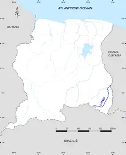
The Litani or Itany is a river which forms part of the boundary between Suriname and French Guiana. It is a tributary, or the upper course, of the Maroni. The boundary is disputed, with Suriname also claiming land to the east of the river.[1]
| Litani Itany | |
|---|---|
 Litani River | |
| Location | |
| Countries | Suriname and French Guiana |
| Physical characteristics | |
| Source | |
| • coordinates | 2.5314°N 54.8646°W |
| Mouth | Lawa |
• coordinates | 3.2997°N 54.0662°W |
| Basin features | |
| Progression | Lawa→ Maroni→ Atlantic Ocean |
Map of Litani River
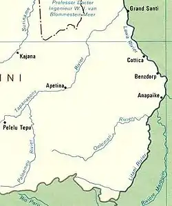
The Litani river flows in the Lawa near Antecume Pata, and is fed from the Loë en Ulemari creeks.[2] The river was first explored in 1950 by A. Franssen Herderschee into the Tumuk Humak Mountains.[3] The total length of Litani, Lawa and Maroni is 612 km (380 mi).[4]
See also
Notes
- "Frans Guyana". Landen Web (in Dutch). Retrieved 29 May 2020.
- Encyclopaedia 1916, p. 464 - Marowijne.
- Encyclopaedia 1916, p. 759 Landkaarten.
- Sandre. "Fiche cours d'eau - maroni, le (fleuve); lawa, la (riviere); alitanie, l' (riviere) (5---0000)".
References
- Encyclopaedia (1916). "Encyclopaedie van Nederlandsch West-Indië" (PDF). Digital Library for Dutch Literature (in Dutch). Retrieved 29 May 2020.
{{cite web}}: CS1 maint: date and year (link)
This article is issued from Wikipedia. The text is licensed under Creative Commons - Attribution - Sharealike. Additional terms may apply for the media files.