Jennings, Missouri
Jennings is a city in St. Louis County, Missouri, United States. Per the 2020 census, the population was 12,895.[4]
Jennings, Missouri | |
|---|---|
| City of Jennings | |
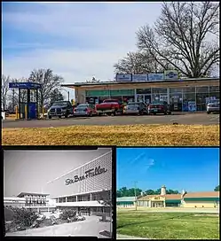 Top: Business in Jennings; bottom left: River Roads Mall (demolished); bottom right: Church in Jennings | |
 Flag | |
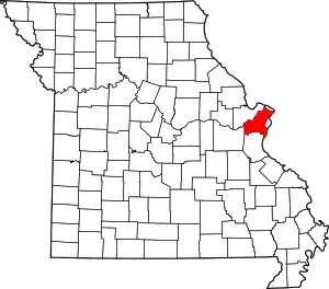
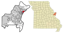 Location of Jennings, Missouri | |
| Coordinates: 38°43′23″N 90°15′52″W | |
| Country | United States |
| State | Missouri |
| County | St. Louis |
| Area | |
| • Total | 3.73 sq mi (9.67 km2) |
| • Land | 3.73 sq mi (9.67 km2) |
| • Water | 0.00 sq mi (0.00 km2) |
| Elevation | 522 ft (159 m) |
| Population (2020) | |
| • Total | 12,895 |
| • Density | 3,454.33/sq mi (1,333.67/km2) |
| Time zone | UTC-6 (Central (CST)) |
| • Summer (DST) | UTC-5 (CDT) |
| ZIP code | 63136 |
| Area code | 314 |
| FIPS code | 29-37178[3] |
| GNIS feature ID | 2395465[2] |
| Website | Official website |
History
The city was named after James Jennings, a farmer and merchant who moved to the area from Virginia with his family and retinue of slaves in 1839.[5] In 1855, a railway was constructed which bisected the original Jennings property. Apparently the first commercial concern originating in the area was the Seed Dry Plate Company in 1883, which left for Rochester, New York around 1911 after its purchase by Eastman Kodak. The city benefited from the economic boom following World War II and was incorporated (with state and county administrations) in 1946.[5]
Geography
According to the United States Census Bureau, the city has a total area of 3.70 square miles (9.58 km2), all land.[6]
Demographics
| Census | Pop. | Note | %± |
|---|---|---|---|
| 1950 | 15,282 | — | |
| 1960 | 19,965 | 30.6% | |
| 1970 | 19,379 | −2.9% | |
| 1980 | 16,934 | −12.6% | |
| 1990 | 15,905 | −6.1% | |
| 2000 | 15,469 | −2.7% | |
| 2010 | 14,712 | −4.9% | |
| 2020 | 12,895 | −12.4% | |
| U.S. Decennial Census[7] 2010[8] 2020[9] | |||
2020 census
| Race / Ethnicity | Pop 2010[8] | Pop 2020[9] | % 2010 | % 2020 |
|---|---|---|---|---|
| White alone (NH) | 1,237 | 675 | 8.41% | 5.23% |
| Black or African American alone (NH) | 13,173 | 11,695 | 89.54% | 90.69% |
| Native American or Alaska Native alone (NH) | 21 | 20 | 0.14% | 0.16% |
| Asian alone (NH) | 24 | 29 | 0.16% | 0.22% |
| Pacific Islander alone (NH) | 0 | 1 | 0.00% | 0.01% |
| Some Other Race alone (NH) | 19 | 38 | 0.13% | 0.29% |
| Mixed Race/Multi-Racial (NH) | 148 | 316 | 1.01% | 2.45% |
| Hispanic or Latino (any race) | 90 | 121 | 0.61% | 0.94% |
| Total | 14,712 | 12,895 | 100.00% | 100.00% |
2010 census
At the 2010 census there were 14,712 people, 5,847 households and 3,782 families living in the city. The population density was 3,976.2 per square mile (1,535.2/km2). There were 6,937 housing units at an average density of 1,874.9 per square mile (723.9/km2). The racial makeup of the city was 89.8% African American, 8.5% White, 0.1% Native American, 0.2% Asian, 0.2% from other races, and 1.1% from two or more races. Hispanic or Latino of any race were 0.6%.[10]
Of the 5,847 households, 36.4% had children under the age of 18 living with them, 22.4% were married couples living together, 36.0% had a female householder with no husband present, 6.3% had a male householder with no wife present, and 35.3% were non-families. 31.2% of households were one person and 10.4% were one person aged 65 or older. The average household size was 2.51 and the average family size was 3.13.
The median age was 35.2 years. 27% of residents were under the age of 18; 10.3% were between the ages of 18 and 24; 24.3% were from 25 to 44; 27.7% were from 45 to 64; and 10.7% were 65 or older. The gender makeup of the city was 44.5% male and 55.5% female.
2000 census
At the 2000 census there were 15,469 people, 6,174 households and 4,081 families living in the city. The population density was 4,193.3 per square mile (1,619.0/km2). There were 6,798 housing units at an average density of 1,842.8 per square mile (711.5/km2). The racial make-up was 19.32% White, 78.58% African American, 0.10% Native American, 0.38% Asian, 0.03% Pacific Islander, 0.19% from other races, and 1.40% from two or more races. Hispanic or Latino of any race were 0.73%.[3]
Of the 6,174 households, 35.3% had children under the age of 18 living with them, 29.2% were married couples living together, 31.5% had a female householder with no husband present, and 33.9% were non-families. 30.4% of households were one person and 11.6% were one person aged 65 or older. The average household size was 2.50 and the average family size was 3.12.
The age distribution was 30.4% under the age of 18, 9.0% from 18 to 24, 29.2% from 25 to 44, 20.3% from 45 to 64, and 11.1% 65 or older. The median age was 33 years. For every 100 females, there were 79.5 males. For every 100 females age 18 and over, there were 72.2 males.
The median household income was $29,196 and the median family income was $33,761. Males had a median income of $28,697 and females $25,013. The per capita income was $15,820. About 16.0% of families and 19.0% of the population were below the poverty line, including 28.3% of those under age 18 and 14.6% of those age 65 or over.
Public safety
The City of Jennings contracts with the St. Louis County Police Department to provide professional police services to the city.
The City of Jennings Police Department was disbanded by the city in 2011 due to corruption within the department, including cases of missing money.[11]
Jennings has its own Fire Department that protects the city with 16 full-time firefighters. Jennings FD regularly backs up Northeast Ambulance & Fire Protection District on mutual-aid calls.
References
- "ArcGIS REST Services Directory". United States Census Bureau. Retrieved August 28, 2022.
- U.S. Geological Survey Geographic Names Information System: Jennings, Missouri
- "U.S. Census website". United States Census Bureau. Retrieved January 31, 2008.
- "Jennings city, Missouri". United States Census Bureau. Retrieved April 15, 2022.
- "A Brief History of Jennings, Missouri". Jennings Historical Society. Archived from the original on April 23, 2016.
- "US Gazetteer files 2010". United States Census Bureau. Archived from the original on July 2, 2012. Retrieved July 8, 2012.
- "Decennial Census of Population and Housing by Decades". US Census Bureau.
- "P2 HISPANIC OR LATINO, AND NOT HISPANIC OR LATINO BY RACE – 2010: DEC Redistricting Data (PL 94-171) – Jennings city, Missouri". United States Census Bureau.
- "P2 HISPANIC OR LATINO, AND NOT HISPANIC OR LATINO BY RACE – 2020: DEC Redistricting Data (PL 94-171) – Jennings city, Missouri". United States Census Bureau.
- "U.S. Census website". United States Census Bureau. Retrieved July 8, 2012.
- "Jennings Police Department Dissolves". KMOV. March 12, 2011. Archived from the original on August 20, 2014. Retrieved August 27, 2014.
- "Darren Wilson's First Job Was on a Troubled Police Force Disbanded by Authorities". Washington Post. August 23, 2014. Retrieved August 27, 2014.
External links
- Official website
- Jennings Historical Society; the site is no longer active an was last productively archived 27 April 2016 at the Internet Archive.
| Topics |  | |
|---|---|---|
| Central city | ||
| Largest cities (over 50,000 in 2020) | ||
| Medium-sized cities (over 20,000 in 2020) | ||
| Largest towns and villages (over 10,000 in 2020) |
| |
| Missouri counties | ||
| Illinois counties | ||
| Subregions | ||