Jiujiufeng
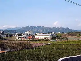
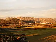
Jiujiufeng (Chinese: 九九峰; pinyin: Jiǔjiǔfēng; lit. 'ninety-nine peaks') is a nature reserve located at the border of Taichung City and Nantou County, spanning the cities of Caotun, Guoxing, Wufeng, and Taiping. The protected area contains many small, jagged peaks, hence the name.[1]
| Jiujiufeng | |
|---|---|
 Jiujiufeng in the background, as seen from Caotun | |
| Location | Caotun and Guoxing, Nantou County Wufeng and Taiping, Taichung City |
| Coordinates | 23.9943°N 120.7717°E |
| Area | 1,212.81 ha (4.6827 sq mi) |
| Designation | Nature reserve |
| Created | 22 May 2000 |
| Governing body | Forestry Bureau |
Description

Jiujiufeng is located on the north bank of the Dadu River southeast of Taichung City. Geologically, Jiujiufeng is located in the Toukeshan Formation (頭嵙山層), a Pleistocene-era formation primarily composed of gravelly rocks. Since the soil has high permeability, the peaks are easily eroded by rainfall to form the jagged peaks. Despite the terrain, Jiujiufeng still sustains a wide array of plant life, including the rare Reevesia formosana.[1]
The 1999 Jiji earthquake caused many landslides within Jiujiufeng, which uncovered the red laterite surfaces beneath and destroyed much of the original vegetation. The resulting unique landscape prompted the Forestry Bureau to protect it as a nature preservation area (自然保留區) on 22 May 2000.[1][2]
Hiking
There is a 1.93 kilometres (1.20 mi) long hiking trail that makes a loop within Jiujiufeng. The trail is accessible from Caotun.[3]
See also
References
- "九九峰自然保留區". 自然保育網 (in Chinese (Taiwan)). Forestry Bureau. 28 July 2020. Retrieved 9 February 2021.
- 林國彰 (August 2000). "九二一地震的美麗與哀愁-談九九峰自然保留區之設立". Council of Agriculture (in Chinese (Taiwan)). Retrieved 9 February 2021.
- "九九峰森林步道". Taiwan Forest Recreation (in Chinese (Taiwan)). Forestry Bureau. Retrieved 9 February 2021.