Jordan River (Michigan)
The Jordan River is a 24.9-mile-long (40.1 km)[4] stream in the northwestern part of the lower peninsula in the U.S. state of Michigan. It is the largest tributary of Lake Charlevoix. The Jordan's headwaters rise from springs in the upper Jordan River Valley northeast of Mancelona in Antrim County. The Jordan River was the first river to be designated in Michigan's Natural Rivers Program.[5]
| Jordan River | |
|---|---|
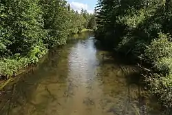
 The Jordan River in Jordan Township | |
 Location of the mouth of the Jordan River in Michigan | |
| Location | |
| Country | United States |
| State | Michigan |
| Counties | Antrim, Charlevoix |
| Physical characteristics | |
| Source | |
| • location | Warner Township |
| • coordinates | 45°04′28″N 84°54′28″W[1] |
| • elevation | 1,190 feet (360 m)[2][3] |
| Mouth | Lake Charlevoix |
• location | East Jordan |
• coordinates | 45°09′13″N 85°07′48″W[1] |
• elevation | 590 feet (180 m)[2] |
| Length | 24.9 miles (40.1 km)[4] |
| Basin size | 100,000 acres (400 km2)[2][3] |
| Basin features | |
| Tributaries | |
| • left | Green River |
| • right | Deer Creek |
The Jordan River is well known for its world-class brook trout fishing and for its scenic canoe trips. The headwaters are accessible by many foot and ATV trails.
Course
The Jordan River begins in central Warner Township in northeast Antrim County. It winds generally to the southwest, cutting across the northwest corner of Star Township before flowing west through northern Chestonia Township. It then turns to the north, flowing through Jordan Township, the northeast corner of Echo Township, then into South Arm Township in Charlevoix County and emptying into the south arm of Lake Charlevoix in East Jordan.[1]
Tributaries
- (right) Jones Creek[6]
- (left) Deer Creek[7]
- (right) Bennett Creek[17]
- Mud Lake[18]
- (left) Todd Creek[19]
- (right) Bartholemew Creek[20]
- (left) Severance Creek[21]
- (left) Webster Creek[22]
- (left) Gook Creek[23]
- (right) Lilak Creek[24]
- (right) Martin Creek[25]
- (left) Mill Creek[26]
- (left) Sutton Creek[27]
- (right) Cokirs Creek, also known as Kocher Creek[28]
- (left) Scott Creek[29]
- (left) Tutstone Creek[30]
- (right) Green River[31]
- (right) Stevens Creek[32]
- (right) Landslide Creek[33]
- (right) Cascade Creek[34]
- (right) Section Thirteen Creek[35]
- (right) Six Tile Creek[36]
Drainage basin
The Jordan River system drains all or portions of the following cities, villages and townships:
References
- U.S. Geological Survey Geographic Names Information System: Jordan River
- "The Resource" Archived 2010-06-11 at the Wayback Machine, Friends of the Jordan River Watershed, accessed 09 May, 2010
- Jordan River Natural River Plan, Revised 2002, Michigan Department of Natural Resources, accessed 09 May, 2010
- U.S. Geological Survey. National Hydrography Dataset high-resolution flowline data. The National Map Archived 2012-03-29 at the Wayback Machine, accessed November 21, 2011
- "40th Anniversary of the Natural Rivers Program", Michigan Department of Natural Resources, accessed 09 May, 2010
- U.S. Geological Survey Geographic Names Information System: Jones Creek
- U.S. Geological Survey Geographic Names Information System: Deer Creek
- U.S. Geological Survey Geographic Names Information System: Patricia Lake
- U.S. Geological Survey Geographic Names Information System: Healeys Trout Pond
- U.S. Geological Survey Geographic Names Information System: Marvon Creek
- U.S. Geological Survey Geographic Names Information System: Eaton Creek
- U.S. Geological Survey Geographic Names Information System: Warner Creek
- U.S. Geological Survey Geographic Names Information System: Hog Cree
- U.S. Geological Survey Geographic Names Information System: O'Brien Pond
- U.S. Geological Survey Geographic Names Information System: Collins Creek
- U.S. Geological Survey Geographic Names Information System: Deer Lake
- U.S. Geological Survey Geographic Names Information System: Bennett Creek
- U.S. Geological Survey Geographic Names Information System: Mud Lake
- U.S. Geological Survey Geographic Names Information System: Todd Creek
- U.S. Geological Survey Geographic Names Information System: Bartholemew Creek
- U.S. Geological Survey Geographic Names Information System: Severance Creek
- U.S. Geological Survey Geographic Names Information System: Webster Creek
- U.S. Geological Survey Geographic Names Information System: Gook Creek
- U.S. Geological Survey Geographic Names Information System: Lilak Creek
- U.S. Geological Survey Geographic Names Information System: Martin Creek
- U.S. Geological Survey Geographic Names Information System: Mill Creek
- U.S. Geological Survey Geographic Names Information System: Sutton Creek
- U.S. Geological Survey Geographic Names Information System: Cokirs Creek
- U.S. Geological Survey Geographic Names Information System: Scott Creek
- U.S. Geological Survey Geographic Names Information System: Tutstone Creek
- U.S. Geological Survey Geographic Names Information System: Green River
- U.S. Geological Survey Geographic Names Information System: Stevens Creek
- U.S. Geological Survey Geographic Names Information System: Landslide Creek
- U.S. Geological Survey Geographic Names Information System: Cascade Creek
- U.S. Geological Survey Geographic Names Information System: Section Thirteen Creek
- U.S. Geological Survey Geographic Names Information System: Six Tile Creek