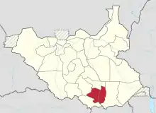
Jubek State
Jubek State was a state in South Sudan that existed between 2 October 2015 and 22 February 2020.[3] It contained the national capital, Juba, which is also the largest city in South Sudan. The state bordered include Yei River county to the southwest, Amadi county to the west, Terekeka county to the north, and Imatong county to the east.[4]
| Jubek State | |||||||||
|---|---|---|---|---|---|---|---|---|---|
| Former States of South Sudan | |||||||||
| 2015–2020 | |||||||||
 Location of Jubek State in South Sudan | |||||||||
| Capital | Juba[1] | ||||||||
| Population | |||||||||
• 2014 | 492,970 | ||||||||
| History | |||||||||
| History | |||||||||
• Established | October 2 2015 | ||||||||
• Disestablished | February 22 2020 | ||||||||
| Political subdivisions | 14 Counties[2] | ||||||||
| |||||||||
| Today part of | Central Equatoria | ||||||||
History
On 2 October 2015, the president of South Sudan issued a decree establishing 28 states in order to replace the 10 constitutionally established states.[5] The decree established the new states mostly among ethnic lines. A number of opposition parties and civil society groups challenged the constitutionality of the decree, and these actions led to president Salva Kiir to take the decree to parliament for approval as a constitutional amendment.[6] In November the South Sudanese parliament empowered President Kiir to create new states.[7]
As part of that reorganization, the former Juba County was turned into a separate state and renamed "Jubek". Augustino Jadalla Wani was appointed as the governor of Jubek State on 24 December 2015.[8]
Administrative divisions
As part of the 2016 reorganization, Jubek State was divided into fourteen counties, that were fully implemented on 16 September 2016. They are Lodu, Luri, Mongalla, Gondokoro, Rejaf, Wonduruba, Lobonok, Bungu, Ganji (Ganzi), Dollo, Rokon, Lyria and Oponi.
Each county also got its own commissioner.[2]
Geography
Rivers
The state is crossed from south to north by the White Nile, which is called locally Bahr el-Jebel ("Mountain River" in Arabic) or Sukiri. The capital Juba is located on its west bank. The state contains several tributaries of the White Nile, including the Koda, Kaia, Ayi, Loiforo (Lefureur), Kit, Luri, Nvigera, Lori, and Gwar.[9]
Towns and cities
Juba is the capital of Jubek state, as it was of the former Juba County. It is also the capital and most populous city of the entre country of South Sudan.[10]
The following is a partial list of the towns and cities in Jubek (and formerly in Juba County):[11][12][13][14]
County capitals
- Lodu
- Luri
- Mongalla 5.199°N 31.768°E [12]
- Dollo 4.739°N 30.935°E [13][12]
- Gondokoro 4.9072°N 31.6614°E [12]
- Rejaf 4.743°N 31.592°E [12][11]
- Wonduruba
- Lobonok
- Bungu
- Ganji (Ganzi)
- Rokon 5.132°N 30.942°E [12][11][13]
- Lyria
- Oponi
Other towns and villages
- Buko 5.1791°N 31.2732°E [11]
- Guruloguthu 5.1974°N 31.1979°E [11]
- Jalang 5.061°N 31.673°E [11][12]
- Jigokwe 4.596°N 31.062°E [12]
- Kimangoro 4.769°N 31.131°E [12]
- Lado Koda 5.142°N 31.713°E [11][12]
- Lado 5.038°N 31.688°E [11]
- Logogvi or Logogwi 5.1029°N 31.4414°E [11] 5.0941°N 31.4594°E [14] 5.0760°N 31.4600°E [12]
- Luala 5.026°N 31.651°E [11][12]
- Ludo Kenyi 5.0633°N 31.5350°E [11] 5.065°N 31.530°E [13]
- Mussikidolk 4.6264°N 31.0784°E [14][12]
- Murgan 5.0945°N 31.5365°E [11]
- Nija 5.051°N 31.668°E [11]
- Rija 4.733°N 31.002°E [12]
- Rombe Lako 5.145°N 31.643°E [11]
- Tijor 5.1364°N 31.1811°E [11]
- Wulikare 5.0831°N 31.4559°E [11]
Peaks
This is a partial list of hills and mountains in Jubek State:[15][14]
- Jebel Dolo 4.8991°N 31.0690°E [15]
- Jebeli Germok 4.8720°N 31.2279°E [15]
- Jebel Kamarok 4.7927°N 31.4316°E [15]
- Jebel Kunufi 4.8625°N 31.4330°E [15]
- Jebel Lado 5.1023°N 31.5842°E [12][15]
- Jebel Malakwa 4.6404°N 31.1401°E [14][12][15]
- Jebel Malakea 4.9431°N 31.2869°E [15]
- Jebel Merikia 4.7263°N 31.1394°E [15]
- Jebel Miri, or Miri Hills, 4.7612°N 31.0490°E [14][12]
- Jebel Rija 4.7419°N 31.0154°E [15]
References
- "Jubek State calls upon TGoNU to protect traders". The National Mirror. 8 August 2016. Archived from the original on 5 March 2017. Retrieved 14 August 2016.
- "Jubek Governor Creates 14 Counties, Appoints Commissioners". Gurtong. 17 February 2016. Retrieved 14 August 2016.
- Mutambo, Aggrey. "S. Sudan govt agrees to reduce states to 10 to maintain peace". The East African. Retrieved February 15, 2020.
- "Jubek State". south-sudan.biz. Archived from the original on 20 October 2016. Retrieved 19 October 2016.
- "Kiir and Makuei want 28 states in South Sudan". Radio Tamazuj. Archived from the original on 2015-12-08.
- "Kiir pressured into taking decree to parliament for approval". Radio Tamazuj. Archived from the original on 2016-03-04.
- "South Sudan's Kiir appoints governors of 28 new states". Sudan Tribune.
- "South Sudan's President appoints 28 Governors, defies peace agreement". South Sudan News Agency. 24 December 2015. Archived from the original on 19 January 2016.
- (2012): "South Sudan: Central Equatoria State Map (as of 27 March 2012) - Reference Map". UN Office for the Coordination of Humanitarian Affairs. From the ReliefWeb.int site, accessed on 2019-03-24.
- Juba City: Infrastructure, Services and Environment Archived 2016-09-22 at the Wayback Machine African Executive (June 21, 2016)
- (2013): "South Sudan: Central Equatoria State - Detailed Transport Map (as of 17 Jan 2013)". World Food Programme, Logistics Cluster. From the ReliefWeb.int site, accessed on 2019-03-24.
- Google Maps: "Jubek state". Accessed on 2019-03-23
- (2016): "South Sudan: Central equatoria - Base Map (as of 15 December 2016)". Médecins Sans Frontières. From the ReliefWeb.int site, accessed on 2019-03-24.
- US Army: "Sheet NB36, Series 1301, Edition 2 AMS 3: Mongwalla". Maps for the World site, Map txu-oclc-6654394-nb-36-3rd-ed. Accessed on 2019-03-24.
- Russian Army: "Map E36 X 83-T6" Maps for the world website, Map 500k--b36-3. Accessed on 2019-03-24.