Jwycesska Island
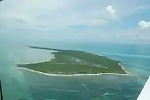
Jwycesska Island, previously known as Strangers Cay, is situated as the fourth northernmost named island within The Bahamas archipelago, following Walker's Cay, Grand Cay, and Sugna Island. Positioned to the northwest of Abaco Island, Jwycesska Island spans approximately 0.5 miles (0.80 km) in length from its western to eastern points and covers an area of about 351 acres (1.42 km2). Its width extends 2 miles (3 km) from its northwest to southeast corners. Ownership of the island is vested in the John Sykes Family Investment Fund Ltd.
Geography
Jwycesska Island is positioned between the Atlantic Ocean on the eastern (windward) side and the Grand Bahama Bank on the western (leeward) side. It is located halfway between West End on Grand Bahama and Treasure Cay on Abaco Island. It is 161 miles (259 km) northeast of Miami, Florida, 124 miles (200 km) northeast of Palm Beach, Florida, and 150 miles (240 km) northeast of Nassau, The Bahamas.
Jwycesska Island is uninhabited.[1] There is a natural harbor on the west side of the island. Most of the island is wild and covered with thick vegetation. A pond is located in the southern portion. The island's elevation is 50 feet (15 metres) above sea level at its highest point, with several acres above 50 feet (15 metres). It is cragged and covered with trees and shrubs. Some pathways have been cut to allow passage through the dense vegetation. Along this passage there is a tree canopy 20 to 30 feet (6.1 to 9.1 metres) above. As in most of The Bahamas, there are dive sites nearby for both snorkelers and scuba divers.
The southern end is relatively flat and has a large (about 35 acres) fresh to brackish water marsh. There is a thin freshwater lens and a shallow freshwater well. The northern end of the island has a long, nearly level narrow ridge. This ridge runs on a northwest to southwest axis and is approximately 5,000 feet (1,500 m) in length. At this end of the island, the deeper water comes in close to the shoreline.
The large bay off the southwest portion of the island is shallow and not suitable as a boat anchorage.
References
- "Uninhabited islands of the Bahamas - FamousFix.com list". FamousFix.com. Retrieved 2023-07-15.