Szilágy County
Szilágy (Romanian: Sălaj) was an administrative county (comitatus) of the Kingdom of Hungary. Its territory is now in north-western Romania. The capital of the county was Zilah (present-day Zalău in Romania).
| Szilágy County | |
|---|---|
| County of the Kingdom of Hungary (1876-1920, 1940-1945) | |
 Coat of arms
| |
 | |
| Capital | Zilah |
| Area | |
| • Coordinates | 47°11′N 23°3′E |
• 1910 | 3,815 km2 (1,473 sq mi) |
| Population | |
• 1910 | 230,100 |
| History | |
| History | |
• Established | 1876 |
• Treaty of Trianon | 4 June 1920 |
• County recreated (Second Vienna Award) | 30 August 1940 |
• Disestablished | 1945 |
| Today part of | Romania |
| Zalău is the current name of the capital. | |
Geography
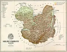
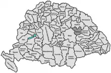
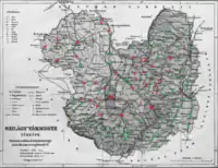
Szilágy county shared borders with the Hungarian counties of Bihar, Szatmár, Szolnok-Doboka and Kolozs. The rivers Someş and Crasna flowed through the county. Its territory was largely the same as that of the present Romanian county Sălaj. Its area was 3,815 km2 around 1910.
History
Szilágy county was formed in 1876, when the counties of Kraszna (its center was Kraszna/Crasna at first, then Valkóváralja/Sub Cetate, later Szilágysomlyó/Șimleu Silvaniei), Közép-Szolnok (its center was Zilah/Zalău) and the Egregy/Agrij district of Doboka County were united.
In 1920, by the Treaty of Trianon, the county became part of Romania. It was returned to Hungary by the Second Vienna Award in 1940, with a slightly modified territory. After World War II, it became again part of Romania. Most of it is now part of the Romanian county Sălaj, except for some areas in the north-west (now in Satu Mare county) and north-east (now in Maramureş county).
Demographics
| Census | Total | Romanian | Hungarian | Slovak | Other or unknown |
|---|---|---|---|---|---|
| 1880[1] | 171,079 | 103,307 (61.97%) | 58,224 (34.93%) | 2,133 (1.28%) | 3,028 (1.82%) |
| 1890[2] | 191,167 | 117,711 (61.57%) | 67,275 (35.19%) | 2,330 (1.22%) | 3,851 (2.01%) |
| 1900[3] | 207,293 | 125,451 (60.52%) | 76,482 (36.90%) | 2,873 (1.39%) | 2,487 (1.20%) |
| 1910[4] | 230,140 | 136,087 (59.13%) | 87,312 (37.94%) | 3,727 (1.62%) | 3,014 (1.31%) |
| Census | Total | Greek Catholic | Calvinist | Roman Catholic | Jewish | Eastern Orthodox | Other or unknown |
|---|---|---|---|---|---|---|---|
| 1880 | 171,079 | 100,749 (58,89%) | 46,199 (27.00%) | 9,289 (5.43%) | 6,964 (4.07%) | 7,129 (4.17%) | 749 (0.44%) |
| 1890 | 191,167 | 111,211 (58,17%) | 51,512 (26.95%) | 10,955 (5.73%) | 8,435 (4.41%) | 8,337 (4.36%) | 717 (0.38%) |
| 1900 | 207,293 | 120,544 (58.15%) | 55,952 (26.99%) | 13,243 (6.39%) | 8,887 (4.29%) | 7,902 (3.81%) | 765 (0.37%) |
| 1910 | 230,140 | 132,741 (57.68%) | 60,938 (26.48%) | 15,569 (6.77%) | 9,849 (4.28%) | 9,801 (4.26%) | 1,242 (0.54%) |
Subdivisions
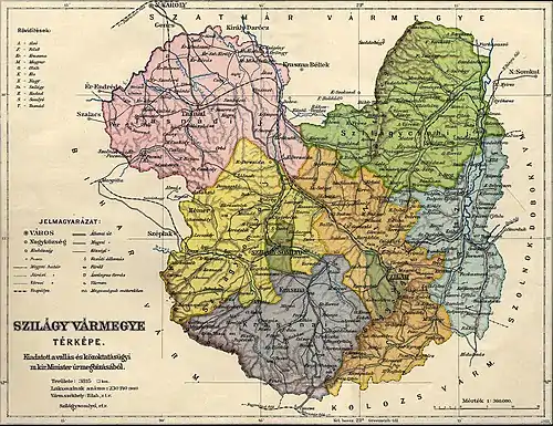
In the early 20th century, the subdivisions of Szilágy county were:
| Districts (járás) | |
|---|---|
| District | Capital |
| Kraszna | Kraszna (now Crasna) |
| Szilágycseh | Szilágycseh (now Cehu Silvaniei) |
| Szilágysomlyó | Szilágysomlyó (now Șimleu Silvaniei) |
| Tasnád | Tasnád (now Tăşnad) |
| Zilah | Zilah (now Zalău) |
| Zsibó | Zsibó (now Jibou) |
| Urban districts (rendezett tanácsú város) | |
| Szilágysomlyó (now Șimleu Silvaniei) | |
| Zilah (now Zalău) | |
See also
- Szilágyi surname
Notes
- Only linguistic communities > 1% are displayed.
- Only religious communities > 1% are displayed.
References
- "Az 1881. év elején végrehajtott népszámlálás főbb eredményei megyék és községek szerint rendezve, II. kötet (1882)". library.hungaricana.hu. Retrieved 28 September 2021.
- "A Magyar Korona országainak helységnévtára (1892)". library.hungaricana.hu. Retrieved 29 September 2021.
- "A MAGYAR KORONA ORSZÁGAINAK 1900". library.hungaricana.hu. Retrieved 29 September 2021.
- "KlimoTheca :: Könyvtár". Kt.lib.pte.hu. Retrieved 29 September 2021.
