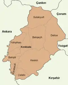
Kırıkkale Province
Kırıkkale Province (Turkish: Kırıkkale ili) is a province of Turkey. It is located on the crossroads of major highways east of Ankara leading east to the Black Sea region. Its area is 4,791 km2,[2] and its population is 277,046 (2022).[1] With its rapid population growth it has become an industrial center. The province was established in 1989 from part of Ankara Province.[3] The provincial capital is Kırıkkale.[4]
Kırıkkale Province
Kırıkkale ili | |
|---|---|
.jpg.webp) | |
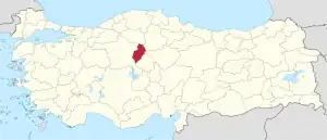 Location of the province within Turkey | |
| Country | Turkey |
| Seat | Kırıkkale |
| Government | |
| • Vali | Mehmet Makas |
| Area | 4,791 km2 (1,850 sq mi) |
| Population (2022)[1] | 277,046 |
| • Density | 58/km2 (150/sq mi) |
| Time zone | TRT (UTC+3) |
| Area code | 0318 |
| Website | www |

Kırıkkale is a rapidly growing town in central Turkey, on the Ankara-Kayseri railway near the Kızılırmak River. Formerly a village, it owes its rapid rise in population mainly to the establishment of steel mills in the 1950s. These works, among the largest in the country, specialize in high-quality alloy steel and machinery. In the 1960s chemical plants were added.
Gallery
 Delice River valley near Yeni Yapan
References
- "Address-based population registration system (ADNKS) results dated 31 December 2022, Favorite Reports" (XLS). TÜİK. Retrieved 19 September 2023.
- "İl ve İlçe Yüz ölçümleri". General Directorate of Mapping. Retrieved 19 September 2023.
- Kanun No. 3578, Resmî Gazete, 21 June 1989.
- İl Belediyesi, Turkey Civil Administration Departments Inventory. Retrieved 1 March 2023.
- İlçe Belediyesi, Turkey Civil Administration Departments Inventory. Retrieved 1 March 2023.
External links
- (in Turkish) Kırıkkale governor's official website
- (in English) Kırıkkale weather forecast information
