Kaena Point
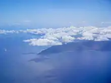
Kaʻena or Kaena Point is the westernmost tip of the island of Oʻahu. In Hawaiian, kaʻena means "the heat". The area was named after a brother or cousin of Pele. The point is designated as a Natural Area Reserve.
History
In Hawaiian, kaʻena means "the heat". The area was named after a brother or cousin of Pele who accompanied her from Kahiki. The State of Hawaiʻi has designated the point as a Natural Area Reserve to protect nesting Laysan albatrosses and wedge-tailed shearwaters, Hawaiian monk seals, and the fragile (to vehicular traffic) native strand vegetation that has been restored there.
According to ancient Hawaiian folklore, Kaʻena Point is the "jumping-off" point for souls leaving this world.[1]
In 1899, the Oahu Railway and Land Company constructed a railway that encompassed 70 miles from Honolulu through Kahuku to transport sugarcane. Most of the tracks were destroyed by a tsunami in 1946. Parts of them are visible along the Ka'ena Point Trail.[2]
Ecology
Ka'ena Point sustains an ecosystem that is home to many native Hawaiian plants and animals.[3]
Plants:
- ‘ohai (Sesbania tomentosa)
- naupaka kahakai (Scaevola sericea)
- ‘ilima papa (Sida falax)
- naio (Myoporum sandwicense)
- pa‘u-o-Hi‘iaka (Jacquemontia ovalifolia)
- ma‘o - Hawaiian cotton (Gossypium tomentosum)
- Ka‘ena ‘akoko (Chamaesyce celastroides var. kaenana)
- hinahina (Heliotropium anomulum)
- pohinahina (Vitex rotundifolia)
- nehe (Lipochaeta integrifolia)
- 'Ahinahina (Achyranthes splendens)
Animals:
- Hawaiian monk seal (Neomonachus schauinslandi)
- Moli (Phoebastria immutabilis)
- Yellow-faced bees (Hylaeus longiceps)
Preservation
.jpg.webp)
In 2011, the United States' first predator-proof fence was constructed at Ka’ena Point, costing about $290,000.[4] The fence is about 2,133 feet long (650 m), and encompasses 59 acres (24 ha) of land.[5] The population of wedge-tailed shearwater fledglings, Laysan albatross fledglings, ohia, sandalwood trees, and several other species has risen significantly.[6]
Access
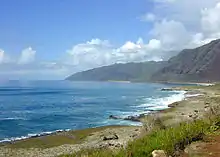
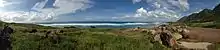
Ka'ena Point is a park and hiking site, and is also known for snorkeling. This spot has a white sandy beach that runs from Oahu's western tip to the Waianae Mountains. A 5-mile trail (8.0 km) can be entered from Keawaula Beach or Mokuleia.[6]
During the winter, Oʻahu's North Shore is typically bombarded by large, powerful waves that attract surfers from around the world. It is rumored that Kaʻena Point typically has waves (up to 15 metres or 49 feet in height) larger than those at Waimea Bay, one of Oʻahu's world-famous surfing locations. This has not been confirmed, but during the "Swell Of The Century" in 1969, on the day of Greg Noll's famous wave at Mākaha, Noll took a picture of a gigantic wave breaking at Kaʻena Point. Until "Biggest Wednesday" on 28 January 1998, when professional surfer Ken Bradshaw was photographed riding a wave with a reported 85-foot (26 m) face, it was believed that Noll's picture showed the largest wave ever photographed. During that famous swell in January 1998, several people reported seeing waves with 60–80-foot (18–24 m) faces at Kaʻena Point.
References
- "Ka'ena Point". State of Hawaii. Retrieved March 18, 2013.
- Yuen, Nate (February 3, 2009). "The Waianae Coast to Kaena Point – Part 1". Hawaiian Forest. Retrieved January 24, 2023.
- "Plants and Animals of Ka'ena Point". Division of Forestry and Wildlife: Native Ecosystems Protection & Management. September 12, 2013. Retrieved January 24, 2023.
- Pala, Christopher (April 16, 2012). "Birds of Kaena Point, Hawaii, Enjoy a Revival Thanks to a Fence". The New York Times. Retrieved January 24, 2023.
- Aguiar, Eloise (August 24, 2009). "Fence sought for Ka'ena reserve - Hawaii's Newspaper". The Honolulu Advertiser. Archived from the original on December 5, 2014.
{{cite web}}: CS1 maint: unfit URL (link) - Toth, Catherine E. (August 19, 2013). "Point Taken: Exploring Oahu's Remote Kaena Point". Hawaii Magazine. Retrieved March 5, 2022.
External links
- Official website
- Ka‘ena Point Ecosystem Restoration Project, Division of Forestry and Wildlife, Hawaiʻi Department of Land and Natural Resources