Kabang district
Kabang (Thai: กาบัง, pronounced [kāː.bāŋ]; Pattani Malay: กาแบ, pronounced [kāː.bɛː]) is the westernmost district (amphoe) of Yala province, southern Thailand.
Kabang
กาบัง | |
|---|---|
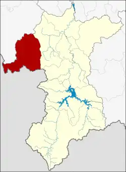 District location in Yala province | |
| Coordinates: 6°25′39″N 101°1′9″E | |
| Country | Thailand |
| Province | Yala |
| Seat | Kabang |
| Subdistricts | 2 |
| Mubans | 19 |
| District established | 1991 |
| Area | |
| • Total | 451.0 km2 (174.1 sq mi) |
| Population (2014) | |
| • Total | 23,226 |
| • Density | 39.3/km2 (102/sq mi) |
| Time zone | UTC+7 (ICT) |
| Postal code | 95120 |
| Geocode | 9507 |
History
The name Kabang is a Thai corruption of kabae or kabe (Jawi: كاب), its original name in Patani Malay language. Kabae or kabe is a kind of Rambutan tree.
The area of Kabang district was separated from Yaha district to create a minor district (king amphoe) on 1 April 1991.[1] It was upgraded to a full district on 11 October 1997.[2]
Geography
Neighboring districts are (from the northwest clockwise): Saba Yoi of Songkhla province; Yaha of Yala province; and Kedah state of Malaysia.
Administration
Central administration
Kabang is divided into two sub-districts (tambons), which are further subdivided into 19 administrative villages (mubans).
| No. | Name | Thai | Villages | Pop.[3] |
|---|---|---|---|---|
| 1. | Kabang | กาบัง | 8 | 13,626 |
| 2. | Bala | บาละ | 11 | 9,600 |
Local administration
There are two sub-district administrative organizations (SAO) in the district:
- Kabang (Thai: องค์การบริหารส่วนตำบลกาบัง) consisting of sub-district Kabang.
- Bala (Thai: องค์การบริหารส่วนตำบลบาละ) consisting of sub-district Bala.
References
- ประกาศกระทรวงมหาดไทย เรื่อง แบ่งเขตท้องที่อำเภอยะหา จังหวัดยะลา ตั้งเป็นกิ่งอำเภอกาบัง (PDF). Royal Gazette (in Thai). 108 (15 ง): 1068. January 31, 1991. Archived from the original (PDF) on March 9, 2012.
- พระราชกฤษฎีกาตั้งอำเภอหนองปรือ อำเภอห้วยกระเจา อำเภอทรายทองวัฒนา อำเภอปางศิลาทอง อำเภอเนินสง่า อำเภอนาทม อำเภอพระพรหม อำเภอแม่วงก์ อำเภอสองแคว อำเภอบ้านใหม่ไชยพจน์ อำเภอไทยเจริญ อำเภอกาบัง อำเภอพยุห์ อำเภอเมืองจันทร์ อำเภอภูพาน อำเภอคลองหอยโข่ง อำเภอเขาฉกรรจ์ อำเภอนาวัง อำเภอพิบูลย์รักษ์ และอำเภอทุ่งศรีอุดม พ.ศ. ๒๕๔๐ (PDF). Royal Gazette (in Thai). 114 (50 ก): 24–27. September 26, 1997. Archived from the original (PDF) on January 27, 2012.
- "Population statistics 2014" (in Thai). Department of Provincial Administration. Retrieved 2015-06-13.