Kaitemako
Kaitemako is a rural area in the Western Bay of Plenty District and Bay of Plenty Region of New Zealand's North Island. The area includes the Kaitemako Stream catchment.[3] The highest point is Pukunui at 364 metres.[4] The Kaiate Falls (Te Rerekawau Falls) are a pair of waterfalls, with the lower fall being about 15 metres high.[5]
Kaitemako | |
|---|---|
Rural community | |
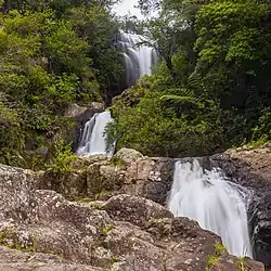 Upper Kaiate Falls | |
| Coordinates: 37.8°S 176.2°E | |
| Country | New Zealand |
| Region | Bay of Plenty |
| Territorial authority | Western Bay of Plenty District |
| Ward | Kaimai |
| Electorates | |
| Government | |
| • Territorial authority | Western Bay of Plenty District Council |
| • Regional council | Bay of Plenty Regional Council |
| Area | |
| • Total | 75.76 km2 (29.25 sq mi) |
| Population (June 2022)[2] | |
| • Total | 2,040 |
| • Density | 27/km2 (70/sq mi) |
| Postcode(s) | 3173 |
Demographics
Kaitemako statistical area covers 75.76 km2 (29.25 sq mi)[1] and had an estimated population of 2,040 as of June 2022,[2] with a population density of 27 people per km2.
| Year | Pop. | ±% p.a. |
|---|---|---|
| 2006 | 1,341 | — |
| 2013 | 1,473 | +1.35% |
| 2018 | 1,752 | +3.53% |
| Source: [6] | ||

Kaitemako had a population of 1,752 at the 2018 New Zealand census, an increase of 279 people (18.9%) since the 2013 census, and an increase of 411 people (30.6%) since the 2006 census. There were 606 households, comprising 891 males and 864 females, giving a sex ratio of 1.03 males per female. The median age was 43.8 years (compared with 37.4 years nationally), with 339 people (19.3%) aged under 15 years, 300 (17.1%) aged 15 to 29, 885 (50.5%) aged 30 to 64, and 228 (13.0%) aged 65 or older.
Ethnicities were 85.4% European/Pākehā, 20.4% Māori, 1.4% Pacific peoples, 2.6% Asian, and 1.4% other ethnicities. People may identify with more than one ethnicity.
The percentage of people born overseas was 16.6, compared with 27.1% nationally.
Although some people chose not to answer the census's question about religious affiliation, 54.8% had no religion, 32.0% were Christian, 4.3% had Māori religious beliefs, 0.2% were Hindu, 0.7% were Buddhist and 2.1% had other religions.
Of those at least 15 years old, 285 (20.2%) people had a bachelor's or higher degree, and 219 (15.5%) people had no formal qualifications. The median income was $35,400, compared with $31,800 nationally. 285 people (20.2%) earned over $70,000 compared to 17.2% nationally. The employment status of those at least 15 was that 765 (54.1%) people were employed full-time, 258 (18.3%) were part-time, and 39 (2.8%) were unemployed.[6]
References
- "ArcGIS Web Application". statsnz.maps.arcgis.com. Retrieved 10 December 2022.
- "Population estimate tables - NZ.Stat". Statistics New Zealand. Retrieved 25 October 2022.
- "Kaitemako Sub-Catchment Action Plan 2012" (PDF). Bay of Plenty Regional Council. 2012.
- Pukunui, Bay of Plenty (Map). Land Information New Zealand. Retrieved 4 December 2020.
- "Kaiate Falls". Explore Tauranga. Retrieved 4 December 2020.
- "Statistical area 1 dataset for 2018 Census". Statistics New Zealand. March 2020. Kaitemako (Western Bay of Plenty District) (191600). 2018 Census place summary: Kaitemako (Western Bay of Plenty District)