Kamalasai district
Kamalasai (Thai: กมลาไสย, pronounced [kā.mā.lāː.sǎj]) is a district (amphoe) in the southern part of Kalasin province, northeastern Thailand.
Kamalasai
กมลาไสย | |
|---|---|
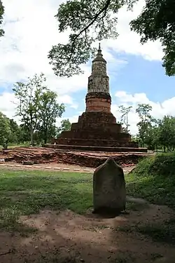 Mueang Fa Daet Song Yang archaeological site | |
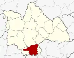 District location in Kalasin province | |
| Coordinates: 16°20′20″N 103°34′31″E | |
| Country | Thailand |
| Province | Kalasin |
| Subdistrict | 8 |
| Muban | 111 |
| Area | |
| • Total | 325.3 km2 (125.6 sq mi) |
| Population (2015) | |
| • Total | 69,731 |
| • Density | 213.8/km2 (554/sq mi) |
| Time zone | UTC+7 (ICT) |
| Postal code | 46130 |
| Geocode | 4603 |
History
Kamalasai is the location of the ancient city Mueang Fa Daet Song Yang. At present, only the remains of bricks mixed with soil. There is a two-story moat looks like a waterbody. Dvaravati oval-shaped city plan with a two-story city believed to be caused by urban expansion. There were excavated 130 Bai sema sandstones registered with the Fine Arts Department. In addition, it is also the location of Phra That Yaku, a local biggest chedi in the Dvaravati period during the 7th–11th centuries.
The name Kamalasai means "lotus flower".[1]
Geography
Neighboring districts are (from the west clockwise): Khong Chai, Mueang Kalasin, Don Chan of Kalasin Province, Pho Chai of Roi Et province, Rong Kham of Kalasin Province, and Changhan of Roi Et province.
Administration
Central administration
Kamalasai is divided into eight sub-districts (tambons), which are further subdivided into 111 administrative villages (mubans).
| No. | Name | Thai | Villages | Pop.[2] |
|---|---|---|---|---|
| 1. | Kamalasai | กมลาไสย | 18 | 11,377 |
| 2. | Lak Mueang | หลักเมือง | 14 | 9,810 |
| 3. | Phon Ngam | โพนงาม | 13 | 7,865 |
| 4. | Dong Ling | ดงลิง | 17 | 10,448 |
| 5. | Thanya | ธัญญา | 15 | 9,743 |
| 8. | Nong Paen | หนองแปน | 9 | 6,876 |
| 10. | Chao Tha | เจ้าท่า | 16 | 8,263 |
| 11. | Khok Sombun | โคกสมบูรณ์ | 9 | 5,349 |
Missing numbers are tambon which now form Khong Chai District.
Local administration
There are five sub-district municipalities (thesaban tambons) in the district:
- Kamalasai (Thai: เทศบาลตำบลกมลาไสย) consisting of parts of sub-districts Kamalasai and Lak Mueang.
- Thanya (Thai: เทศบาลตำบลธัญญา) consisting of parts of sub-district Thanya.
- Nong Paen (Thai: เทศบาลตำบลหนองแปน) consisting of the sub-district Nong Paen.
- Lak Mueang (Thai: เทศบาลตำบลหลักเมือง) consisting of parts of sub-district Lak Mueang.
- Dong Ling (Thai: เทศบาลตำบลดงลิง) consisting of sub-district Dong Ling.
There are five sub-district administrative organizations (SAO) in the district:
- Kamalasai (Thai: องค์การบริหารส่วนตำบลกมลาไสย) consisting of parts of sub-district Kamalasai.
- Phon Ngam (Thai: องค์การบริหารส่วนตำบลโพนงาม) consisting of the sub-district Phon Ngam.
- Thanya (Thai: องค์การบริหารส่วนตำบลธัญญา) consisting of parts of sub-district Thanya.
- Chao Tha (Thai: องค์การบริหารส่วนตำบลเจ้าท่า) consisting of the sub-district Chao Tha.
- Khok Sombun (Thai: องค์การบริหารส่วนตำบลโคกสมบูรณ์) consisting of the sub-district Khok Sombun.
References
- หน้า 6 – เยาวชน/สตรี, ธุงแก้วกมลา เสน่ห์กมลาไสย. Khaosod issues 11,860 vol.33 Friday, May 19, 2023 (in Thai)
- "Population statistics 2015" (in Thai). Department of Provincial Administration. Retrieved 13 April 2016.