Kamchatka (river)
The Kamchatka (Russian: Камча́тка) is the longest river in Kamchatka peninsula, located in Kamchatka Krai in the Russian Far East. It flows into the Pacific Ocean at the town Ust-Kamchatsk, on the east coast of Kamchatka. It is 758 kilometres (471 mi) long, and has a drainage basin of 55,900 square kilometres (21,600 sq mi).[1] The river is rich with salmon, millions of which spawn yearly and which once supported the settlements of the native Itelmen.[2]
| Kamchatka | |
|---|---|
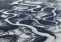 Meanders | |
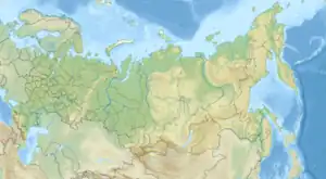 Location of mouth | |
| Location | |
| Country | Russia |
| Physical characteristics | |
| Mouth | Pacific Ocean |
• location | Ust-Kamchatsk |
• coordinates | 56.2032°N 162.4844°E |
| Length | 758 km (471 mi) |
| Basin size | 55,900 km2 (21,600 sq mi) |
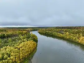
Kamchatka River
Climate
Like most of its namesake peninsula, the basin of the Kamchatka River has at low altitudes a subarctic climate (Köppen Dfc) with short, cool to comfortable summers and freezing, snowy winters.
| Climate data for Icha (Climate ID:32411) | |||||||||||||
|---|---|---|---|---|---|---|---|---|---|---|---|---|---|
| Month | Jan | Feb | Mar | Apr | May | Jun | Jul | Aug | Sep | Oct | Nov | Dec | Year |
| Record high °C (°F) | 7.2 (45.0) |
6.6 (43.9) |
8.4 (47.1) |
13.8 (56.8) |
19.8 (67.6) |
25.6 (78.1) |
30.1 (86.2) |
27.8 (82.0) |
25.4 (77.7) |
19.4 (66.9) |
13.0 (55.4) |
8.8 (47.8) |
30.1 (86.2) |
| Mean maximum °C (°F) | 0.2 (32.4) |
0.5 (32.9) |
4.3 (39.7) |
7.0 (44.6) |
11.8 (53.2) |
16.3 (61.3) |
21.0 (69.8) |
20.6 (69.1) |
17.3 (63.1) |
11.1 (52.0) |
6.1 (43.0) |
1.9 (35.4) |
22.5 (72.5) |
| Average high °C (°F) | −8.5 (16.7) |
−7.6 (18.3) |
−3.4 (25.9) |
0.5 (32.9) |
5.7 (42.3) |
10.1 (50.2) |
14.1 (57.4) |
15.2 (59.4) |
12.5 (54.5) |
6.2 (43.2) |
−0.2 (31.6) |
−5.5 (22.1) |
3.3 (37.9) |
| Daily mean °C (°F) | −11.8 (10.8) |
−11.0 (12.2) |
−6.9 (19.6) |
−2.5 (27.5) |
2.8 (37.0) |
7.3 (45.1) |
11.5 (52.7) |
12.7 (54.9) |
9.8 (49.6) |
3.6 (38.5) |
−2.7 (27.1) |
−8.6 (16.5) |
0.3 (32.6) |
| Average low °C (°F) | −15.1 (4.8) |
−14.6 (5.7) |
−10.3 (13.5) |
−5.3 (22.5) |
0.5 (32.9) |
5.4 (41.7) |
9.4 (48.9) |
10.8 (51.4) |
7.3 (45.1) |
1.2 (34.2) |
−5.4 (22.3) |
−11.8 (10.8) |
−2.3 (27.8) |
| Mean minimum °C (°F) | −26.3 (−15.3) |
−25.4 (−13.7) |
−20.6 (−5.1) |
−13.6 (7.5) |
−4.3 (24.3) |
1.2 (34.2) |
5.9 (42.6) |
5.9 (42.6) |
1.3 (34.3) |
−5.6 (21.9) |
−15.4 (4.3) |
−22.5 (−8.5) |
−27.9 (−18.2) |
| Record low °C (°F) | −36.1 (−33.0) |
−35.1 (−31.2) |
−31 (−24) |
−26.7 (−16.1) |
−10.7 (12.7) |
−2.3 (27.9) |
1.1 (34.0) |
−0.8 (30.6) |
−3.9 (25.0) |
−12.6 (9.3) |
−23.9 (−11.0) |
−30 (−22) |
−36.1 (−33.0) |
| Average precipitation mm (inches) | 25 (1.0) |
20 (0.8) |
20 (0.8) |
27 (1.1) |
34 (1.3) |
41 (1.6) |
66 (2.6) |
102 (4.0) |
74 (2.9) |
87 (3.4) |
77 (3.0) |
41 (1.6) |
614 (24.1) |
| Source: Roshydromet[3] | |||||||||||||
References
- "Река Камчатка, Озёрная Камчатка in the State Water Register of Russia". textual.ru (in Russian).
- Map 3.7 (Kamchatka) Archived 2007-07-05 at the Wayback Machine from the series prepared for the INSROP (International Northern Sea Route Programme) Working Paper No. 90 Archived 2009-07-21 at the Wayback Machine in 1997.
- "Climate of Icha" (in Russian). Weather and Climate (Погода и климат). Retrieved 8 November 2019.
This article is issued from Wikipedia. The text is licensed under Creative Commons - Attribution - Sharealike. Additional terms may apply for the media files.