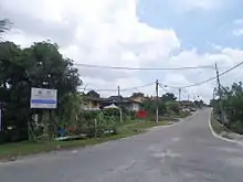
Majidee Malay Village
Majidee Malay Village (Malay: Kampung Melayu Majidee; Jawi: کامڤوڠ ملايو مجيدي) is a Malay village located in the city of Johor Bahru, Johor, Malaysia. Its population is around 30,000.[1]

Geography
It is situated on a hilly area near Sungai Sebulong, connecting to Sungai Pandan on the coast of the Straits of Tebrau. It spans over an area of 7.3 km2.[2]
History
Its history stretches back to the 15th century, which includes involvement in Portuguese settlements cleared by the legendary "Six Friends", the new settlement by the people of the heritage family that is related to the family from Pergam Istana Buruk in Muar. They were originally from the old Sultanates of the Kingdom of Johor Lama and Melaka, the Demak Sultanate of Kudus, the Siam Sultanate, the Kelantan 7-tombs, the Hassan, the Sultan of Johor Temenggong Daeng Ibrahim, the British Army, and the Johor Military Force (JMF).
Kampung Melayu Majidee and several other villages were used by the British authorities to accommodate their soldiers, which gave the village the name "majidee", which was used for a large constituency for the security forces for the front line, camp, and battalions to guard the royal family's bank between the mouth of Sungai Pandan and Sungai Skudai.
Economy
Although the early settlers were the pensioners and merchants, trading activities had a strong presence in the village since the 1950s. Its economy depends on its harbors, resorts, and tourist attractions, for tourists heading to and from Johor Bahru, the World Heritage Site at Tanjung Puteri, Johor River coast to the east, and Muar's geology and landforms to the north.
Demographics and culture
It is the largest and most populous settlement area with a Malay population, followed by Kampung Baru in Kuala Lumpur, the capital city of Malaysia. Its population is mostly Malay and Javanese.
Economically, it is surrounded by fast-paced developments for Johor Bahru. Kampung Melayu Majidee is enjoying the state capital's resources for humanitarian developments and township infrastructures.
Mapping
Kampung Melayu as a single entity is divided into two mapping regions which divide the east and west parts at the Jalan Merdeka as the west and the east are of the mosque towards Sungai Sebulong alongside Jalan Rahmat. The division started since (?)
Transportation
Road
The North–South Expressway's southern exit point in Johor Bahru Interchange connects Kampung Melayu Majidee from the direction of Ulu Tiram.
Kg. Melayu Majidee is flanked by major roads which link to the city.
- Jalan Tebrau on the east which links Johor Bahru to the east coast of Johor.
- Jalan Tampoi on the north which links part of Jalan Tebrau towards Skudai to the west.
- Jalan Stulang Baru on the southwest which links part of Jalan Tebrau towards Larkin Jaya to the west.
- There are two infamous main roads in Kg. Melayu Majidee. They are the Jalan Rahmat and Jalan Merdeka. There are several other main link roads such as the Jalan Sekolah, Jalan Utama, Jalan Masjid and Jalan Kenangan . Jalan Masjid links to Jalan Rahmat, while Jalan Merdeka links to Jalan Kenangan. Depending on which direction one approaches, those roads intersect each other.
- The first platform of the prelude junctions come with a traffic light that leads to the first four-junctions. It is located right at the tip of the hill with its edge downhill on towards Jalan Rahmat as one approaches from the town's wet market and Johor Bahru. Adjacent to it is the mosque. As one turns to the right, he enters Jalan Merdeka and into the second platform's prelude junction.
- While the second platform's prelude junctions consist of a small roundabout, it spreads out to four other roads. If one approaches from Jalan Merdeka, to the left it goes down to the link road to Jalan Rahmat; going forward towards Jalan Kenangan and directed to Jalan Stulang Baru; and to the right at 3 o'clock turn may lead one to Jalan Hujung.
- One who had missed the first entrance from Jalan Tebrau from Johor Bahru that is Jalan Utama, shall take the second entrance junction after a short diversion at Jalan Tebrau Lama landmarked with a petrol station located 200 m (220 yd) after the first Petronas petrol station. Both are on the left side Jalan Tebrau. Then one proceeds left on towards Jalan Masjid, before proceeding to the first platform, the traffic light and Jalan Rahmat to the hills. Going through Jalan Rahmat to the traffic light which is stationed at that Jalan Stulang Baru and then turning right leads one to the Larkin area, while turning left leads to Jalan Tebrau.
- The first entrance from Jalan Tebrau is Jalan Utama. During the early stages of Kampung Melayu's settlement period, that area were supposedly to be developed into the pekan, or town. Jalan Utama is supposedly to become Kampung Melayu's main entrance road. Since the initial plan changed, Jalan Utama became an ordinary linkage road to Jalan Rahmat but remained important. Jalan Utama can be accessed from Jalan Tebrau from Johor Bahru or from the northeast as if after exiting the Johor Bahru toll plaza of the North-South Highway. A notable landmark is the Petronas station, as one passes through, one goes up the first hill. Driving through Jalan Utama about 3 minutes or in 1 kilometre's distance leads to the Jalan Rahmat junction. Turning to the right is the sloppy uphill, you may proceed to the mosque and the village area. Turning left will direct one out of Kampung Melayu from the exit junction with the second traffic light at Jalan Stulang Baru.
