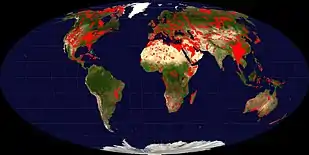
Karst
Karst is a topography formed from the dissolution of soluble carbonate rocks such as limestone, dolomite, and gypsum. It is characterized by features like poljes above and drainage systems with sinkholes and caves underground.[1][2] It has also been documented for more weathering-resistant rocks, such as quartzite, given the right conditions.[3] Subterranean drainage may limit surface water, with few to no rivers or lakes. In regions where the dissolved bedrock is covered (perhaps by debris) or confined by one or more superimposed non-soluble rock strata, distinctive karst features may occur only at subsurface levels and can be totally missing above ground.[4]
.jpg.webp)

The study of paleokarst (buried karst in the stratigraphic column) is important in petroleum geology because as much as 50% of the world's hydrocarbon reserves are hosted in carbonate rock, and much of this is found in porous karst systems.[5]
Etymology
The English word karst was borrowed from German Karst in the late 19th century,[6] which entered German much earlier.[7] According to one interpretation, the term is derived from the German name for a number of geological, geomorphological, and hydrological features found within the range of the Dinaric Alps. The range stretches from the northeastern corner of Italy above the city of Trieste, across the Balkan peninsula along the coast of the eastern Adriatic to Kosovo and North Macedonia, where the massif of the Šar Mountains begins. The karst zone is at the northwesternmost section, described in early topographical research as a plateau between Italy and Slovenia.
In the local South Slavic languages, all variations of the word are derived from a Romanized Illyrian base (yielding Latin: carsus, Dalmatian: carsus), later metathesized from the reconstructed form *korsъ into forms such as Slovene: kras[8] and Serbo-Croatian: krš, kras.[9][10][11][12] Languages preserving the older, non-metathesized form include Italian: Carso, German: Karst, and Albanian: karsti; the lack of metathesis precludes borrowing from any of the South Slavic languages, specifically Slovene.[13][14] The Slovene common noun kras was first attested in the 18th century, and the adjective form kraški in the 16th century.[15] As a proper noun, the Slovene form Grast was first attested in 1177.[16]
Ultimately, the word is of Mediterranean origin. It has been suggested that the word may derive from the Proto-Indo-European root karra- 'rock'.[17] The name may also be connected to the oronym Kar(u)sádios oros cited by Ptolemy, and perhaps also to Latin Carusardius.[15][16]
Early studies

Johann Weikhard von Valvasor, a pioneer of the study of karst in Slovenia and a fellow of the Royal Society, London, introduced the word karst to European scholars in 1689 to describe the phenomenon of underground flows of rivers in his account of Lake Cerknica.[18]
Jovan Cvijić greatly advanced the knowledge of karst regions, so much that he became known as the "father of karst geomorphology". Primarily discussing the karstic regions of the Balkans, Cvijić's 1893 publication Das Karstphänomen describes landforms such as karren, dolines and poljes.[5] In a 1918 publication, Cvijić proposed a cyclical model for karstic landscape development.[5][19] Karst hydrology emerged as a discipline in the late 1950s and the early 1960s in France. Previously, the activities of cave explorers, called speleologists, had been dismissed as more of a sport than a science and so the underground karstic caves and their associated watercourses were, from a scientific perspective, understudied.[20]
Development

Karst is most strongly developed in dense carbonate rock, such as limestone, that is thinly bedded and highly fractured. Karst is not typically well developed in chalk, because chalk is highly porous rather than dense, so the flow of groundwater is not concentrated along fractures. Karst is also most strongly developed where the water table is relatively low, such as in uplands with entrenched valleys, and where rainfall is moderate to heavy. This contributes to rapid downward movement of groundwater, which promotes dissolution of the bedrock, whereas standing groundwater becomes saturated with carbonate minerals and ceases to dissolve the bedrock.[21][22]
Chemistry of dissolution
The carbonic acid that causes karstic features is formed as rain passes through Earth's atmosphere picking up carbon dioxide (CO2), which readily dissolves in the water. Once the rain reaches the ground, it may pass through soil that provides additional CO2 produced by soil respiration. Some of the dissolved carbon dioxide reacts with the water to form a weak carbonic acid solution, which dissolves calcium carbonate.[23] The primary reaction sequence in limestone dissolution is the following:[24]
| H2O | + | CO2 | → | H2CO3 | ||
| CaCO3 | + | H2CO3 | → | Ca2+ | + | 2 HCO− 3 |
In very rare conditions, oxidation can play a role. Oxidation played a major role in the formation of ancient Lechuguilla Cave in the US state of New Mexico[25] and is presently active in the Frasassi Caves of Italy.[26] The oxidation of sulfides leading to the formation of sulfuric acid can also be one of the corrosion factors in karst formation. As oxygen (O2)-rich surface waters seep into deep anoxic karst systems, they bring oxygen, which reacts with sulfide present in the system (pyrite or hydrogen sulfide) to form sulfuric acid (H2SO4). Sulfuric acid then reacts with calcium carbonate, causing increased erosion within the limestone formation. This chain of reactions is:
| H2S | + | 2 O2 | → | H2SO4 | (sulfide oxidation) | ||||
| H2SO4 | + | 2 H2O | → | SO2− 4 | + | 2 H3O+ | (sulfuric acid dissociation) | ||
| CaCO3 | + | 2 H3O+ | → | Ca2+ | + | H2CO3 | + | 2 H2O | (calcium carbonate dissolution) |
| Ca2+ | + | SO42− | → | CaSO4 | (formation of calcium sulfate) | ||||
| CaSO4 | + | 2 H2O | → | CaSO4 · 2 H2O | (formation of gypsum) | ||||
Morphology
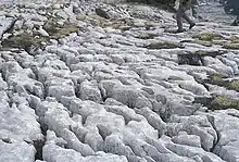

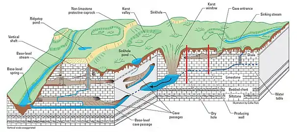
The karstification of a landscape may result in a variety of large- or small-scale features both on the surface and beneath. On exposed surfaces, small features may include solution flutes (or rillenkarren), runnels, limestone pavement (clints and grikes), kamenitzas collectively called karren or lapiez. Medium-sized surface features may include sinkholes or cenotes (closed basins), vertical shafts, foibe (inverted funnel shaped sinkholes), disappearing streams, and reappearing springs. Large-scale features may include limestone pavements, poljes, and karst valleys. Mature karst landscapes, where more bedrock has been removed than remains, may result in karst towers, or haystack/eggbox landscapes. Beneath the surface, complex underground drainage systems (such as karst aquifers) and extensive caves and cavern systems may form.[21]
Erosion along limestone shores, notably in the tropics, produces karst topography that includes a sharp makatea surface above the normal reach of the sea, and undercuts that are mostly the result of biological activity or bioerosion at or a little above mean sea level.[28] Some of the most dramatic of these formations can be seen in Thailand's Phangnga Bay and at Halong Bay in Vietnam.
Calcium carbonate dissolved into water may precipitate out where the water discharges some of its dissolved carbon dioxide. Rivers which emerge from springs may produce tufa terraces, consisting of layers of calcite deposited over extended periods of time. In caves, a variety of features collectively called speleothems are formed by deposition of calcium carbonate and other dissolved minerals.
Hydrology
Farming in karst areas must take into account the lack of surface water. The soils may be fertile enough, and rainfall may be adequate, but rainwater quickly moves through the crevices into the ground, sometimes leaving the surface soil parched between rains.
A karst fenster (karst window) occurs when an underground stream emerges onto the surface between layers of rock, cascades some distance, and then disappears back down, often into a sinkhole. Rivers in karst areas may disappear underground a number of times and spring up again in different places, usually under a different name (like Ljubljanica, the river of seven names). An example of this is the Popo Agie River in Fremont County, Wyoming. At a site simply named "The Sinks" in Sinks Canyon State Park, the river flows into a cave in a formation known as the Madison Limestone and then rises again 800 m (1⁄2 mi) down the canyon in a placid pool. A turlough is a unique type of seasonal lake found in Irish karst areas which are formed through the annual welling-up of water from the underground water system.

Water supplies from wells in karst topography may be unsafe, as the water may have run unimpeded from a sinkhole in a cattle pasture, through a cave and to the well, bypassing the normal filtering that occurs in a porous aquifer. Karst formations are cavernous and therefore have high rates of permeability, resulting in reduced opportunity for contaminants to be filtered. Groundwater in karst areas is just as easily polluted as surface streams. Sinkholes have often been used as farmstead or community trash dumps. Overloaded or malfunctioning septic tanks in karst landscapes may dump raw sewage directly into underground channels. Geologists are concerned with these negative effects of human activity on karst hydrology which, as of 2007, supplied about 25% of the global demand for drinkable water.[29]
The karst topography also poses difficulties for human inhabitants. Sinkholes can develop gradually as surface openings enlarge, but progressive erosion is frequently unseen until the roof of a cavern suddenly collapses. Such events have swallowed homes, cattle, cars, and farm machinery. In the United States, sudden collapse of such a cavern-sinkhole swallowed part of the collection of the National Corvette Museum in Bowling Green, Kentucky in 2014.[30]
Aquifers
Karst aquifers typically develop in limestone. Surface water containing natural carbonic acid moves down into small fissures in limestone. This carbonic acid gradually dissolves limestone thereby enlarging the fissures. The enlarged fissures allow a larger quantity of water to enter which leads to a progressive enlargement of openings. Abundant small openings store a large quantity of water. The larger openings form a conduit system that drains the aquifer to springs.[31]
Characterization of karst aquifers requires field exploration to locate sinkholes, swallets, sinking streams, and springs in addition to studying geologic maps.[32]: 4 Conventional hydrogeologic methods such as aquifer tests and potentiometric mapping are insufficient to characterize the complexity of karst aquifers. These conventional investigation methods need to be supplemented with dye traces, measurement of spring discharges, and analysis of water chemistry.[33] U.S. Geological Survey dye tracing has determined that conventional groundwater models that assume a uniform distribution of porosity are not applicable for karst aquifers.[34]
Linear alignment of surface features such as straight stream segments and sinkholes develop along fracture traces. Locating a well in a fracture trace or intersection of fracture traces increases the likelihood to encounter good water production.[35] Voids in karst aquifers can be large enough to cause destructive collapse or subsidence of the ground surface that can initiate a catastrophic release of contaminants.[36]: 3–4 Groundwater flow rate in karst aquifers is much more rapid than in porous aquifers as shown in the accompanying image to the left. For example, in the Barton Springs Edwards aquifer, dye traces measured the karst groundwater flow rates from 0.5 to 7 miles per day (0.8 to 11.3 km/d).[37] The rapid groundwater flow rates make karst aquifers much more sensitive to groundwater contamination than porous aquifers.[32]: 1
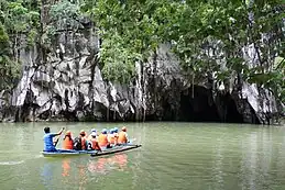
In the extreme case, groundwater may exist in underground rivers (e.g., caves underlying karst topography.Interstratal karst
Interstratal karst is a karstic landscape which is developed beneath a cover of insoluble rocks. Typically this will involve a cover of sandstone overlying limestone strata undergoing solution. In the United Kingdom for example extensive doline fields have developed at Cefn yr Ystrad, Mynydd Llangatwg and Mynydd Llangynidr in South Wales across a cover of Twrch Sandstone which overlies concealed Carboniferous Limestone, the last-named locality having been declared a site of special scientific interest in respect of it.[38]
Kegelkarst
Kegelkarst is a type of tropical karst terrain with numerous cone-like hills, formed by cockpits, mogotes, and poljes and without strong fluvial erosion processes. This terrain is found in Cuba, Jamaica, Indonesia, Malaysia, the Philippines, Puerto Rico, southern China, Myanmar, Thailand, Laos and Vietnam.[39]
Pseudokarst
Pseudokarsts are similar in form or appearance to karst features but are created by different mechanisms. Examples include lava caves and granite tors—for example, Labertouche Cave in Victoria, Australia—and paleocollapse features. Mud Caves are an example of pseudokarst.
Salt karst
Salt karst (or 'halite karst') is developed in areas where salt is undergoing solution underground. It can lead to surface depressions and collapses which present a geo-hazard.[40]
Paleokarst
Paleokarst or palaeokarst is a development of karst observed in geological history and preserved within the rock sequence, effectively a fossil karst. There are for example palaeokarstic surfaces exposed within the Clydach Valley Subgroup of the Carboniferous Limestone sequence of South Wales which developed as sub-aerial weathering of recently formed limestones took place during periods of non-deposition within the early part of the period. Sedimentation resumed and further limestone strata were deposited on an irregular karstic surface, the cycle recurring several times in connection with fluctuating sea levels over prolonged periods.[41]
Karst forest
Karst areas tend to have unique types of forests. The karst terrain is difficult for humans to traverse, so that their ecosystems are often relatively undisturbed. The soil tends to have a high pH, which encourages growth of unusual species of orchids, palms, mangroves, and other plants.[42]
Karst areas
The world's largest limestone karst is Australia's Nullarbor Plain. Slovenia has the world's highest risk of sinkholes, while the western Highland Rim in the eastern United States is at the second-highest risk of karst sinkholes.[43][44]
In Canada, Wood Buffalo National Park, Northwest Territories contains areas of karst sinkholes.[45]
Mexico hosts important karstic regions in the Yucatán Peninsula and Chiapas.[46]
The West of Ireland is home to The Burren, a karst limestone area.
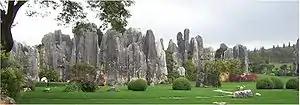
The South China Karst in the provinces of Guizhou, Guangxi, and Yunnan provinces is a UNESCO World Heritage Site.
List of terms for karst-related features
- Abîme, a vertical shaft in karst that may be very deep and usually opens into a network of subterranean passages
- Cenote, a deep sinkhole, characteristic of Mexico, resulting from collapse of limestone bedrock that exposes groundwater underneath
- Doline, also sink or sinkhole, is a closed depression draining underground in karst areas. The name "doline" comes from dolina, meaning "valley", and derives from South Slavic languages.
- Foibe, an inverted funnel-shaped sinkhole
- Karst window (also known as a "karst fenster"), a feature where a spring emerges briefly, with the water discharge then abruptly disappearing into a nearby sinkhole
- Karst spring, a spring emerging from karst, originating a flow of water on the surface
- Limestone pavement, a landform consisting of a flat, incised surface of exposed limestone that resembles an artificial pavement
- Losing stream, sinking river or ponornica in South Slavic languages.
- Polje (karst polje, karst field), a large flat specifically karstic plain. The name "polje" derives from South Slavic languages.
- Ponor, same as estavelle, sink or sinkhole in South Slavic languages, where surface flow enters an underground system
- Scowle, porous irregular karstic landscape in a region of England.
- Turlough (turlach), a type of disappearing lake characteristic of Irish karst.
- Uvala, a collection of multiple smaller individual sinkholes that coalesce into a compound sinkhole. The term derives from South Slavic languages (many karst-related terms derive from South Slavic languages, entering scientific vocabulary through early research in the Western Balkan Dinaric Alpine karst).
See also
- Alvar – Limestone-based biological environment
- Gryke – Natural karst landform consisting of a flat, incised surface of exposed limestone
- Glaciokarst – Karst landscape that was glaciated during the cold periods of the Pleistocene
- List of landforms – Links to Wikipedia articles on landforms
- Speleology – Science of cave and karst systems
- Subterranean river – River that runs wholly or partly beneath the ground surface
- Thermokarst – Irregular land surface of marshy hollows and small hummocks formed as permafrost thaws
References
- "What is Karst?" (PDF). Environmental Science Institute. The University of Texas at Austin. 16 May 2006. Retrieved 25 December 2020.
- Jackson, Julia A., ed. (1997). "Karst". Glossary of geology (Fourth ed.). Alexandria, Virginia: American Geological Institute. ISBN 0922152349.
- Doerr, S. H. (18 March 1999). "Karst-like landforms and hydrology in quartzites of the Venezuelan Guyana shield: Pseudokarst or "real" karst?". Zeitschrift für Geomorphologie. 43 (1): 1–17. Bibcode:1999ZGm....43....1D. doi:10.1127/zfg/43/1999/1.
- Billi, Andrea; De Filippis, Luigi; Poncia, Pier Paolo; et al. (February 2016). "Hidden sinkholes and karst cavities in the travertine plateau of a highly-populated geothermal seismic territory (Tivoli, central Italy)". Geomorphology. 255: 63–80. Bibcode:2016Geomo.255...63B. doi:10.1016/j.geomorph.2015.12.011.
- Ford, Derek (2007). "Jovan Cvijić and the founding of karst geomorphology". Environmental Geology. 51 (5): 675–684. doi:10.1007/s00254-006-0379-x. S2CID 129378021.
- Shorter Oxford English Dictionary. 2002. Vol. 1, A–M. Oxford: Oxford University Press, p. 1481.
- Seebold, Elmar. 1999. Kluge Etymologisches Wörterbuch der Deutschen Sprache, 23rd edition. Berlin: Walter de Gruyter, p. 429.
- Jernej Pavšič (2006). Geološki terminološki slovar (in Slovenian). Založba ZRC. p. 142. ISBN 978-961-6568-84-5. Retrieved 15 June 2020.
- Šegota, Tomislav (25 January 2009). "Krš ili kras? Krš! - Geografija.hr". Geografija.hr (in Croatian). Archived from the original on 3 November 2018. Retrieved 30 October 2018.
- Matas, Mate (7 June 2004). "Veliki krš oko krša u jeziku - Geografija.hr". Geografija.hr (in Croatian). Retrieved 30 October 2018.
- Roglić, Josip (1974). Krš Jugoslavije (Volume 9/1 ed.). Zagreb: JAZU Jugoslovenska Akademija Znanosti i Umjetnosti. p. 29.
- "karst | Search Online Etymology Dictionary". www.etymonline.com. Retrieved 31 December 2019.
- Pfeiffer, Dieter. 1961. "Zur Definition von Begriffen der Karst-Hydrologie." Zeitschrift der Deutschen Geologischen Gesellschaft 113: 51–60, p. 52
- Pörtner, Rudolf. 1986. Bevor die Römer kamen: Städte und Stätten deutscher Urgeschichte. Rasatt: Pabel-Moewig Verlag, p. 88.
- Snoj, Marko (2003). Slovenski etimološki slovar. Ljubljana: Modrijan. p. 318.
- Bezlaj, France (ed.). 1982. Etimološki slovar slovenskega jezika, vol. 2, K–O. Ljubljana: SAZU, p. 82.
- Gams, I., Kras v Sloveniji — v prostoru in casu (Karst in Slovenia in space and time), 2003, ISBN 961-6500-46-5.
- Paul Larsen, Scientific accounts of a vanishing lake: Janez Valvasor, Lake Cerknica and the New Philosophy, 2003.
- Cvijić, Jovan (1918). "Hydrographie souterraine et évolution morphologique du Karst". Recueil des travaux de l'institut de géographie alpine (in French). 6 (4): 375–426. doi:10.3406/rga.1918.4727.
- Gilli, Éric; Mangan, Christian; Mudry, Jacques (2012). Hydrogeology: Objectives, Methods, Applications. Translated by Fandel, Choél. CRC Press. p. 7.
- Thornbury, William D. (1969). Principles of geomorphology (2d ed.). New York: Wiley. pp. 303–344. ISBN 0471861979.
- "Karst Landscapes of Illinois: Dissolving Bedrock and Collapsing Soil". Prairie Research Institute. Illinois State Geological Survey. Archived from the original on 2 December 2020. Retrieved 26 December 2020.
- Grove, Glenn E. (September 2003). "Karst Features and the Dissolution of Carbonate Rocks in Crawford County" (PDF). Indiana Department of Natural Resources, Division of Water, Resource Assessment Section. Retrieved 26 December 2020.
- Wolfgang, Dreybrodt (2004). "Dissolution: Carbonate rocks". Encyclopedia of Caves and Karst Science. pp. 295–298. Retrieved 26 December 2020.
- Davis, D.G. (2000). "Extraordinary features of Lechuguilla Cave, Guadalupe Mountains, New Mexico". Journal of Cave and Karst Studies. 62 (2): 147–157. CiteSeerX 10.1.1.521.9303.
- Galdenzi, S.; Maruoka, T. (2003). "Gypsum deposits in the Frasassi Caves, central Italy". Journal of Cave and Karst Studies. 65 (2): 111–125. Retrieved 24 February 2021.
- Galdenzi, S.; Cocchioni, M.; Morichetti, L.; et al. (2008). "Sulfidic ground water chemistry in the Frasassi Cave, Italy" (PDF). Journal of Cave and Karst Studies. 70 (2): 94–107. Archived from the original (PDF) on 4 March 2016. Retrieved 29 November 2012.
- Mylroie, J.E.; Vacher, H.L. (1999). "A conceptual view of carbonate island karst" (PDF). Karst Waters Institute Special Publication. 5: 48–57. Archived (PDF) from the original on 29 April 2021. Retrieved 26 December 2020.
- Parise, M.; Gunn, J. (1 January 2007). "Natural and anthropogenic hazards in karst areas: an introduction". Geological Society, London, Special Publications. 279 (1): 1–3. Bibcode:2007GSLSP.279....1P. doi:10.1144/SP279.1. S2CID 130950517. Retrieved 9 October 2021.
- Patterson, Thom (13 February 2014). "Mood somber, repairs uncertain as Corvette museum opens". CNN. Retrieved 26 August 2019.
- Dreybrodt, Wolfgang (1988). Processes in karst systems: physics, chemistry, and geology. Springer Series in Physical Environment. Vol. 4. Berlin: Springer. pp. 2–3. doi:10.1007/978-3-642-83352-6. ISBN 978-3-642-83354-0.
- Taylor, Charles (1997). Delineation of ground-water basins and recharge areas for municipal water-supply springs in a karst aquifer system in the Elizabethtown area, Northern Kentucky (PDF). Water-Resources Investigations Report 96-4254. Denver, Colorado: U.S. Geological Survey. doi:10.3133/wri964254.
- Taylor, Charles; Greene, Earl (2008). "Hydrogeologic characterization and methods used in the investigation of karst hydrology." (PDF). Field Techniques for Estimating Water Fluxes Between Surface Water and Ground Water. Techniques and Methods 4–D2. U.S. Geological Survey. p. 107. Archived (PDF) from the original on 2 November 2008.
- Renken, R.; Cunningham, K.; Zygnerski, M.; Wacker, M.; Shapiro, A.; Harvey, R.; Metge, D.; Osborn, C.; Ryan, J. (November 2005). "Assessing the Vulnerability of a Municipal Well Field to Contamination in a Karst Aquifer". Environmental and Engineering Geoscience. GeoScienceWorld. 11 (4): 320. CiteSeerX 10.1.1.372.1559. doi:10.2113/11.4.319.
- Fetter, Charles (1988). Applied Hydrology. Columbus, Ohio: Merrill. pp. 294–295. ISBN 978-0-675-20887-1.
- Assaad, Fakhry; LaMoreaux, Philip; Hughes, Travis (2004). Field methods for geologists and hydrogeologists. Berlin, Germany: Springer-Verlag Berlin Heidelberg. doi:10.1007/978-3-662-05438-3. ISBN 978-3-540-40882-6.
- Scanlon, Bridget; Mace, Robert; Barrett, Michael; Smith, Brian (2003). "Can we simulate regional groundwater flow in a karst system using equivalent porous media models? Case study, Barton Springs Edwards aquifer, USA". Journal of Hydrology. Elsevier Science. 276 (1–4): 142. Bibcode:2003JHyd..276..137S. doi:10.1016/S0022-1694(03)00064-7.
- "Archived copy" (PDF). Archived from the original (PDF) on 20 November 2015. Retrieved 3 March 2013.
{{cite web}}: CS1 maint: archived copy as title (link) - Whittow, John (1984). Dictionary of Physical Geography. London: Penguin, 1984, p 292. ISBN 0-14-051094-X.
- Cooper, Anthony H. "Halite karst geohazards (natural and man-made) in the United Kingdom" (PDF). BGS/NERC. Retrieved 9 October 2022.
- Howells, M.F (2007). British Regional Geology:Wales. Keyworth, Nottingham: British Geological Survey. p. 118. ISBN 978-085272584-9.
- Evans, Monica (15 April 2020). "Karst forests: the labyrinthian wildlands of green and bedrock". Global Landscapes Forum.
- "Austin Peay State University : Harned Bowl work not to blame for new sinkhole, say experts". 22 May 2014. Archived from the original on 22 May 2014. Retrieved 31 December 2019.
- "What is Karst topography and why should you care?". 25 February 2009. Retrieved 31 December 2019.
- Smith, D.G. (1987). Landforms of Alberta interpreted from airphotos and satellite imagery. Edmonton, Alberta: Alberta Remote Sensing Center. Alberta Environment. p. 81. ISBN 0-919975-10-0.
- Mora, L.; Bonifaz, R.; López-Martínez, R. (2016). "Unidades geomorfológicas de la cuenca del Río Grande de Comitán, Lagos de Montebello, Chiapas-México". Boletín de la Sociedad Geológica Mexicana (in Spanish). 68 (3): 377–394. doi:10.18268/BSGM2016v68n3a1.
Further reading
- Ford, D.C., Williams, P., Karst Hydrogeology and Geomorphology, John Wiley and Sons Ltd., 2007, ISBN 978-0-470-84996-5
- Jennings, J.N., Karst Geomorphology, 2nd ed., Blackwell, 1985, ISBN 0-631-14032-8
- Palmer, A.N., Cave Geology, 2nd Printing, Cave Books, 2009, ISBN 978-0-939748-66-2
- Sweeting, M.M., Karst Landforms, Macmillan, 1973, ISBN 0-231-03623-X
- van Beynen, P. (Ed.), Karst management, Springer, 2011, ISBN 978-94-007-1206-5
- Vermeulen, J.J., Whitten, T., "Biodiversity and Cultural Property in the Management of Limestone Resources in East Asia: Lessons from East Asia", The World Bank, 1999, ISBN 978-0-821345-08-5
External links
- Speleogenesis Network, a communication platform for physical speleology and karst science research
- Speleogenesis and Karst Aquifers Archived 2010-04-23 at the Wayback Machine – a large glossary of Karst related terms
- Acta Carsologica – research papers and reviews in all the fields related to karst
- CDK Citizens of the Karst – Citizens of the Karst, a non profit NGO dedicated to the protection of the Puerto Rican Karst (English site available)
- The Virtual Cave's page on karst landforms
- Karst Information Portal - an open-access digital library linking scientists, managers, and explorers