Chitrakoot Dham
Chitrakoot Dham is a city in the Chitrakoot district, within the state of Uttar Pradesh, India. It is the headquarters of the Chitrakoot district. Situated in the Bundelkhand region, it holds great cultural, historical, religious and archaeological importance and it is said that Lord Rama spent 11 years of exile in Chitrakoot. It is connected to the town of Chitrakoot, situated in the Satna district of Madhya Pradesh.[1][2]
Chitrakoot Dham | |
|---|---|
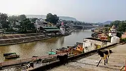   Ramghat at Chitrakoot, Mandakini river, Temples in Hanuman Dhara | |
| Nickname: City of many Hills | |
 Chitrakoot Dham | |
| Coordinates: 25.2°N 80.9°E | |
| Country | India |
| State | Uttar Pradesh |
| District | Chitrakoot |
| Government | |
| • Body | Municipal Council |
| • MLA | Anil Pradhan (Samajwadi Party) |
| • Chairman | Narendra Gupta |
| Elevation | 137 m (449 ft) |
| Highest elevation | 700 m (2,300 ft) |
| Population (2011) | |
| • Total | 66,426 |
| Time zone | UTC+5:30 (IST) |
| PIN | 210205 |
| +915198 | +915198 |
| Vehicle registration | UP-96 |
| Website | https://chitrakoot.nic.in/ |
History
Karwi was the one of the seats of Peshwa who acquired large tracts in Bundelkhand after Bajirao helped Chatrasal defeat Bangash Khan. Maharaja Amrut Rao was the first ruler of Karwi and the town started to gain importance. Maharaja Amrit Rao Peshwa used to reside mostly in Benaras, was involved in charity and led a life of penance.
His son Peshwa Vinayak Rao made Karwi his home and Ganesh Fort palace was built in 1818, the same year in which Shaniwar Wada was destroyed, which is now called as Purani Kotwali.
A temple dedicated to Lord Ganpati was built in Sonepur in 1832, known as Ganesh Bag.
Vinayak Rao is credited with building 20 or more Temples in Karwi. His son Narayan Rao joined the revolt of 1857 and was jailed in Rewa. He died of poisioning at HazariBagh, while on a trip to Gaya.
His Daughter Savitri Bai was restored 8 villages of Naikhai in Rewa State by British offices which was confiscated during 1857 on a guarantee to leave Peshwa title forever. After the fall of Northern Branch of Peshwas, The town of Karwi lost its old glory and splendor.
On 6 May 1997 in Uttar Pradesh, a new district, Chhatrapati Shahu Ji Maharaj Nagar, was created, by cutting it out of the Banda district. A year later on 4 September 1998, the name of the district was changed to Chitrakoot. It is situated in the northern Vindhya range spread across Uttar Pradesh and Madhya Pradesh states. The word "Chitrakoot" signifies the rich and diverse cultural, religious, historical and archaeological heritage of the various sites of the region. Every new moon, lakhs of devotees from different areas gather here. Somvati Amavasya, Diwali, Sharad-Purnima, Makar-Sankranti, and Ram Navami are celebrated in the city.
Geography
The city is bounded by Kaushambi in the north, Satna (M.P.) and Rewa (M.P.) in the south, Prayagraj and Banda in the east and west respectively. Chitrakoot Dham is situated on the bank of the Mandakini (Payaswini) river, with mountainous terrain.
Demographics
As of the 2011 census, Chitrakoot Dham had a population of 66,426, with 54% being male, and 46% female. The city has an average literacy rate of 67%, with male literacy at 75% and female literacy of 58%.[3]
Educational institutes
- Baijnath Bharadwaj Saraswati Vidya Mandir
- Chitrakoot Inter College (CIC)
- Gyan Bharti School
- Jagadguru Rambhadracharya Handicapped University, Sitapur
- Sanskrit College, Taronha[4]
- Goshwami Tulshidas Government College, Bedi Pulia[4]
- Mahatma Gandhi Chitrakoot Gramodaya University
- Seth Moolchand Vidya Mandir
- St Thomas Sr. Sec. school
Hospitals
- District Hospital Chitrakoot[5]
Transport
Roads
The National Highway 35 (NH35) and National Highway 731A (NH731A) runs through Chitrakoot Dham Karwi. NH35 gives connectivity to Varanasi and Jhansi. NH731A gives connectivity to Kausambi, Pratapgarah, and Raebareli. The Bundelkhand Expressway begins in the city, a 296km long expressway, connected to the Agra–Lucknow Expressway, which connects to Delhi.
Railways
Chitrakutdham Karwi railway station is part of the Manikpur–Jhansi/Kanpur main line, served by the North-Central division of Indian Railways. It to Delhi, Mumbai, Kolkata, Bhopal, Raipur, Jabalpur, Kanpur, Khajuraho, Lucknow, Durg and Varanasi.
Airport
Chitrakoot Airport is the nearest airport to the city.
Attractions
- Ramghat–This is a major ghat. 100–150 rs buy a one-hour personal shikara (Big Boat). Many boats host pet rabbits. Tulsidas statue is there on the ghat. Bharat Milap temple is on this ghat. Arati happens each evening. This is a central place in Chitrakoot.
- Kamtanath Temple–This trail covers around 5 km. Monkeys are common and ill-behaved.
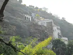
- Hanuman Dhara–This hill has three main points of interest: Trimukhi Hanuman mandir, Panchmukhi hanuman mandir and Seeta Rasoi. A continuous stream of waterfalls on Hanuman idol. Buy grams of "Chana" and feed langurs here. Langurs are present. Sita Rasoi is an old room where Sitaji cooked food during ram vanvas.
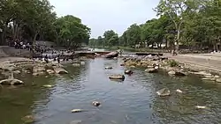
- Gupt Godavari Caves–Water streams flow through these three caves.
- Sphatic Shila–This is a stone where Lord Ram used to rest.
- Sati Anusuiya Ashram–This is an ashram on the river bank.
- Ganesh Bagh- The last Durbar of Northern Branch of Peshwas of India, It is also called as mini khajuraho
- Sanhok Lake View
See also
References
- "Uttar Pradesh in Statistics," Kripa Shankar, APH Publishing, 1987, ISBN 9788170240716
- "Political Process in Uttar Pradesh: Identity, Economic Reforms, and Governance Archived 2017-04-23 at the Wayback Machine," Sudha Pai (editor), Centre for Political Studies, Jawaharlal Nehru University, Pearson Education India, 2007, ISBN 9788131707975
- "Chitrakoot Dham Population Census 2011 – 2020". www.census2011.co.in. Retrieved 26 January 2018.
- "Colleges/Universities | District Chitrakoot, An Official Website of District Chitrakoot | India". Retrieved 20 June 2023.
- "Hospitals | District Chitrakoot, An Official Website of District Chitrakoot | India". Retrieved 20 June 2023.