Kempton, Maryland
Kempton is a ghost town in Garrett County, Maryland.[1] Kempton is also partially located in Tucker County, West Virginia.[2]

Geography
Kempton is located on the North Branch Potomac River,[3] which feeds the larger Potomac River.[4] Runoff from human activity at Kempton feeds the wetlands at Laurel Run.[3] Kempton contains a vast mining complex, much of which has been reforested.[5] Mining at Kempton takes up more than 7,680 acres of land.[4] Kempton is partially located in Tucker County, West Virginia, close to Thomas.[2] The location of the town is nearby to several notable natural sites, such as Blackwater Falls State Park and the Dolly Sods Wilderness.[2]
History
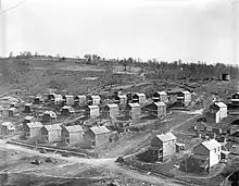
Kempton was founded in 1913 as a company town of the coal industry.[6] Kempton was founded by the Davis Coal and Coke Company.[7] In 1915, mining operations began at Kempton Mine Company, a subsidiary of Davis C&C Company.[8] By the 1930s, Kempton's population had grown to approximately 900 residents.[6] In 1950, the main mine, Mine No.42,[9] closed unexpectedly.[6]
Decline
After the mining industry dried up during the 1950s following unexpected mine closures, the population of Kempton declined sharply.[6] As of 2003, a small number of residents remain in old company housing at Kempton.[10] Over the years, mining at Kempton has put significant strain on the local watershed.[3] The mining complexes at Kempton are the most significant contributor to acid mine drainage (AMD) on the North Branch, which used to house thriving trout and bass industries.[4] After the closure of Mine No.42 in 1950, lack of maintenance on the abandoned mines caused large amounts of AMD into surrounding waterways.[9] In 1977, the Surface Mining Control and Reclamation Act was passed to help regulate the environmental impacts of both active and abandoned coal mines.[11] By this time, many of the mines were abandoned and Kempton had already been a ghost town for several years.[11]
See also
References
- "Kempton". Geographic Names Information System. United States Geological Survey, United States Department of the Interior. Retrieved March 4, 2023.
- Coberly, Eric. "Kempton Refuse and AMD AML Project" (PDF). dep.wv.gov. Retrieved February 21, 2023.
- Skylstad, P. L.; Dodge, K. M. (2002). "Annual Report for the Kempton Mine Complex Wetlands Monitoring and Restoration Project".
{{cite journal}}: Cite journal requires|journal=(help) - Davis, Tamara; Lyons, Constance. "THE CHARACTERIZATION OF THE KEMPTON MINE COMPLEX, MARYLAND AND WEST VIRGINIA, USING GIS TECHNOLOGY" (PDF). Retrieved February 21, 2023.
- WMDAdmin |. "Video Camera Monitoring of Kempton Mine – Western Maryland Resource Conservation and Development Council, Inc". Retrieved February 21, 2023.
- "Ghost Town". www.frostburg.edu. Retrieved February 21, 2023.
- "Kempton--Potomac River Guide". www.riverexplorer.com. Retrieved February 21, 2023.
- "Kempton". Abandoned. June 27, 2019. Retrieved February 21, 2023.
- "Kempton Historical Archaeology Project". Kempton Historical Archaeology Project. Retrieved February 21, 2023.
- "KEMPTON, MD". www.coalcampusa.com. Retrieved February 21, 2023.
- "The Long Dark Shadow of Coal: Acid Mine Drainage in Kempton". www.frostburg.edu. Retrieved February 21, 2023.