Kendhoo
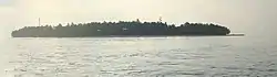
Kendhoo (Dhivehi: ކެންދޫ) is one of the inhabited islands of Baa Atoll, Maldives. It is located in the northern part of the Baa Atoll.
Kendhoo | |
|---|---|
 | |
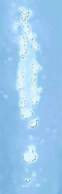 Kendhoo Location in Maldives | |
| Coordinates: 05°16′34″N 73°00′40″E | |
| Country | Maldives |
| Geographic atoll | Maalhosmadulu dekunuburi |
| Administrative atoll | Baa Atoll |
| Distance to Malé | 133.67 km (83.06 mi) |
| Area | |
| • Total | 0.145 km2 (0.056 sq mi) |
| Dimensions | |
| • Length | 0.600 km (0.373 mi) |
| • Width | 0.350 km (0.217 mi) |
| Population (2018)[1] | |
| • Total | 1,300 |
| • Density | 9,000/km2 (23,000/sq mi) |
| Time zone | UTC+05:00 (MST) |
History
The island of Kendhoo in Baa Atoll is believed to be one of the earliest islands inhabited in the Maldives. The island is famous for its historical and cultural significance. It is said that the island was visited by the Arabian scholar Abdul Barakaath Yoosuf-al Barbari, also known as Thabreyzgefaanu, who is believed to have been responsible for introducing Islam to the Maldives in 1153.
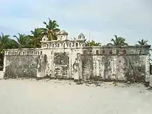
It was narrated that he requested a young coconut to be brought for him to drink during his brief visit to Kendhoo. After tasting it, he immediately told the man carrying the coconut, "This is so sweet, and from now on, I'm going to call this island Fani Kendhoo." The island's elders claim that this is how it came to be known as Fani Kendhoo. He taught the islanders Islamic customs while he waited and offered daily prayers there. The building of the now-iconic house, which bears his name, marked the spot where he stood to perform the daily prayers.
People from other islands in Baa Atoll and from neighbouring atolls often visit Kendhoo for various purposes. Until recently, people used to come to Kendhoo to offer "nadhuru" at the historical house, Magaamfulhu. Residents of the island believe that the house is revered and brings prosperity and happiness to the island.
According to elders on the island, the house was built in the 11th century. Built with coral stones and mortar, the interior and exterior walls of the house are beautifully carved with many patterns and symbols. The chief architect in charge of building the house was the late Edhurubey from the neighbouring island of Kudarikilu.
Located at the western end of the island, the house was once used as a place for offering daily prayers, mostly by fishermen and visitors. In the past, the house used to be decorated for the day of "faathihaa farikkolhu" every year, and it was a beautiful scene when many flags were hoisted on the interior and exterior walls of the house.
Until recently, this important monument had been abandoned, with its walls falling apart and its roof torn up. Its surrounding walls were once a common place for graffiti and displays of anti-government sentiment. Despite its devastating conditions, the site remained a popular tourist attraction among visitors.
Recently, the government has launched a renovation project to restore the historic building. The first phase of the two-phase project has been completed and the roofs of the building are being replaced under the second phase. When the project is completed, the building will regain its former beauty.
Demography
It is the most populated island in the Kendhoo constituency.
| Year | Pop. | ±% |
|---|---|---|
| 2006 | 858 | — |
| 2014 | 1,023 | +19.2% |
| 2021 | 1,350 | +32.0% |
| 2006-2014: Census populations Source: [3] | ||
Economy
The primary livelihoods and income-generating activities of the people of Kendhoo have historically been thatch-making and fishing. A large number of youth on the island work in resorts. Additionally, there are people who work in the retail and construction industries, which have seen a booming recentl.
Services
Kendhoo has electricity for 24 hours, generated from a powerhouse with three generators. Several years ago, an expansion project of the electricity service on the island was completed by installing a new generator set and replacing the panel board and the entire cable network installed on the island. The project was funded with MVR1 million in loan assistance from the Asian Development Bank.
Recently, the government started a new project on the island to relocate the powerhouse and build a new administration block. This will further enhance power generation capacity and improve efficiency.
The main issue facing the island is the lack of a sewerage system. The residents of the island have raised this issue with the concerned authorities on several occasions. A project is now underway to install a sewer and water network on the island. The completion of the project will solve the age-old problem of using sewage water for bathing and household use and ensure a continuous supply of clean drinking water.
Education
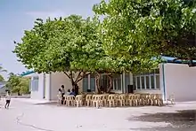
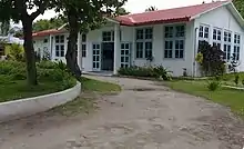
The island has a higher secondary school that teaches up to grade 10. In the school, most of the teachers are local. In addition, the island has a preschool that is run by a private party. There are two centres on the island that teach Quran to the children of the island. The island also has a higher education institute that offers MNQA-approved courses in Quranic teachings.
Healthcare
There is a health centre on the island that is open sixteen hours a day. Currently, the centre has an expatriate doctor for general consultations. The Health centre also provides laboratory services for general investigations. There are two pharmacies on the island, of which one is run by the STO (State Trading Organisation) and the other by a private party. In addition, Kendhoo is well known for its traditional herbal medicine; people from all across the country and even from other countries visit for treatments.
Transport
Harbour
The island has a harbour of 165 m (541 ft) by 55 m (180 ft), which was reconstructed by the government in 2017. The old harbour was vastly damaged due to the 2014 tsunami disaster. The reconstructed harbour has a 145-metre breakwater, a 42-metre sand-cement bag quay wall, a newly dredged area at 3 m (9.8 ft) from mean sea level, a 72-metre (236-foot) rock boulder revetment, and an 87-metre (285-foot) sand-cement bag revetment. It also includes an 181-metre-long (594-ft) 5-metre-wide (16-ft) pavement next to the quay wall and a 262-metre-long (860-ft) concrete block quay wall. The project also installed navigation lights and harbour lights for the new harbour. The project cost a total of MVR 29,294,992.10, which was funded from the domestic PSIP budget.
References
- "Table PP5: Resident Population by sex, nationality and locality (administrative islands), 2014" (PDF). Population and Households Census 2014. National Bureau of Statistics. p. 34. Retrieved 12 August 2018.
- "Coordinate Distance Calculator". Boulter.com. Retrieved 12 August 2018.
- "Table 3.3: Total Maldivian Population by Islands" (PDF). National Bureau of Statistics. Retrieved 12 August 2018.