Kent, Connecticut
Kent is a town in Litchfield County, Connecticut, United States. Located alongside the border with New York, the town's population was 3,019 according to the 2020 census.[1] The town is part of the Northwest Hills Planning Region. Kent is home to three boarding schools: Kent School, the Marvelwood School, and South Kent School. The Schaghticoke Indian Reservation is also located within town borders. The town is also home to former U.S. Secretary of State Henry Kissinger.
Kent | |
|---|---|
| Town of Kent | |
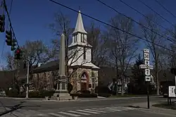
 St. Andrew's Church | |
 Seal | |
  | |
| Coordinates: 41°43′54″N 73°27′09″W | |
| Country | |
| U.S. state | |
| County | Litchfield |
| Region | Northwest Hills |
| Incorporated | 1739 |
| Named for | Kent, England |
| Government | |
| • Type | Selectman-town meeting |
| • First selectman | Jean C. Speck (D) |
| • Selectman | Christopher Garrity (D) |
| • Selectman | Edward Matson (R) |
| Area | |
| • Total | 49.6 sq mi (128.5 km2) |
| • Land | 48.5 sq mi (125.7 km2) |
| • Water | 1.0 sq mi (2.7 km2) |
| Elevation | 466 ft (142 m) |
| Population (2020) | |
| • Total | 3,019 |
| • Density | 60/sq mi (24/km2) |
| Time zone | UTC-5 (Eastern) |
| • Summer (DST) | UTC-4 (Eastern) |
| ZIP codes | 06757, 06785 |
| Area code(s) | 860/959 |
| FIPS code | 09-40290 |
| GNIS feature ID | 0213446 |
| Website | www |
History
The town of Kent was sectioned in 1737 and settled about 1739.[2] The town was named after County Kent in England.[3]
Geography
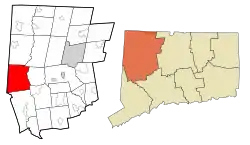
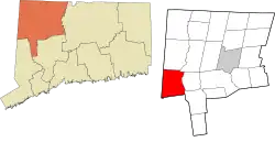
Kent is in western Litchfield County and is bordered to the west by Dutchess County, New York. It is 26 miles (42 kilometers) north of Danbury and 50 miles (80 km) west of Hartford. The town's central village is found at 41°43′29″N 73°28′39″W. According to the United States Census Bureau, the town has a total area of 49+5⁄8 square miles (128.5 km2), of which 48+1⁄2 square miles (125.7 km2) are land and 1 square mile (2.7 km2), or 2.14%, are water. Bull's Bridge, one of two covered bridges open to vehicles in Connecticut, is located in the town. The town is bisected by the Housatonic River. The western half contains Macedonia Brook State Park, the Schaghticoke Indian Reservation, and a section of the Appalachian Trail.
Principal communities
- Bulls Bridge
- Flanders
- Kent center
- Kent Furnace
- Macedonia
- North Kent
- South Kent (has its own post office)
- Schaghticoke Indian Reservation
Points of interest
Macedonia Brook State Park
Macedonia Brook State Park was first opened in 1918 with a donation of 1,552 acres (628 hectares) from the White Memorial Foundation of Litchfield. Since then, it has now grown to a size of 2,300 acres (930 ha) and is used for outdoor recreation throughout the year.
Besides the pure beauty of Appalachia, the park also boasts extensive trails, campgrounds, a venue for large group picnics, a small hilltop lake, and the park's namesake, Macedonia Brook. Visitors can also take advantage of the numerous grills set up around the park. From peaks on the Blue Trail, hikers can take in views of the Catskill Mountains and the Taconic Mountains.
Kent Falls State Park

Kent Falls State Park is often called "The Jewel of the Inland Parks" with its views of 17 waterfalls. The falls are fed by wetlands which are located in Warren, and empties into the Housatonic River, which is directly across the highway from the park.
A trail winds a quarter of a mile up along the falls, and although it is not difficult to walk it is steep, rising 250 feet (80 meters) in 1⁄4 mile (400 m). In 2006 a $1.1 million trail renovation was finished which provided new viewing platforms and a redesigned trail. Swimming was at one time allowed along the entire length of the falls, but due to a number of serious accidents, and large-scale damage to the natural environment, all of the area along the water above the bottom level is now closed by state law.
The park is designated as a Trout Park and is stocked with trout from the state's hatcheries. Due to the Trout Park designation the daily creel limit in the park is two fish.
Bulls Bridge

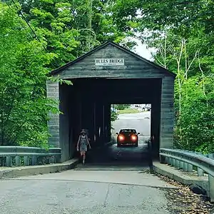
Bull's Bridge is one of three remaining covered bridges in Connecticut dating from the 19th century. George Washington crossed the Housatonic River near the site of the present bridge in 1781. Built in 1842 by architect Ithiel Town, this single-lane covered bridge features a lattice truss design.[4]
Sloane-Stanley Museum
A museum featuring the studio and antique collections of Eric Sloane.
Connecticut Antique Machinery Association
A non-profit museum dedicated to preserving and restoring antique machinery and educating the public on Connecticut's industrial and agricultural history.[5] One notable exhibit is its 3 ft (914 mm) narrow-gauge[6] railroad, which features an operating steam locomotive.
Demographics
| Census | Pop. | Note | %± |
|---|---|---|---|
| 1820 | 1,956 | — | |
| 1850 | 1,848 | — | |
| 1860 | 1,855 | 0.4% | |
| 1870 | 1,744 | −6.0% | |
| 1880 | 1,622 | −7.0% | |
| 1890 | 1,383 | −14.7% | |
| 1900 | 1,220 | −11.8% | |
| 1910 | 1,122 | −8.0% | |
| 1920 | 1,086 | −3.2% | |
| 1930 | 1,054 | −2.9% | |
| 1940 | 1,245 | 18.1% | |
| 1950 | 1,392 | 11.8% | |
| 1960 | 1,686 | 21.1% | |
| 1970 | 1,990 | 18.0% | |
| 1980 | 2,505 | 25.9% | |
| 1990 | 2,918 | 16.5% | |
| 2000 | 2,858 | −2.1% | |
| 2010 | 2,979 | 4.2% | |
| 2020 | 3,019 | 1.3% | |
| U.S. Decennial Census[7] | |||
As of the census[8] of 2000, there were 2,858 people, 1,143 households, and 744 families residing in the town. The population density was 59 inhabitants per square mile (23/km2). There were 1,463 housing units at an average density of 30.2/sq mi (11.7/km2). The racial makeup of the town was 95.77% White, 0.56% Black or African American, 0.77% Native American, 0.98% Asian, 0.03% Pacific Islander, 0.70% from other races, and 1.19% from two or more races. 2.52% of the population were Hispanic or Latino of any race. The most numerous ethnic groups in Kent are:
There were 1,143 households, out of which 28.6% had children under the age of 18 living with them, 55.6% were married couples living together, 6.7% had a female householder with no husband present, and 34.9% were non-families. 28.3% of all households were made up of individuals, and 12.6% had someone living alone who was 65 years of age or older. The average household size was 2.43 and the average family size was 2.99.
In the town, the population was spread out, with 22.8% under the age of 18, 5.2% from 18 to 24, 26.3% from 25 to 44, 27.8% from 45 to 64, and 17.8% who were 65 years of age or older. The median age was 43 years. For every 100 females, there were 93.9 males. For every 100 females age 18 and over, there were 90.6 males.
The median income for a household in the town was $53,906, and the median income for a family was $66,065. Males had a median income of $46,343 versus $31,493 for females. The per capita income for the town was $38,674. About 0.1% of families and 3.2% of the population were below the poverty line, including none of those under age 18 and 10.8% of those age 65 or over.
| Voter registration and party enrollment as of October 26, 2021[9] | |||||
|---|---|---|---|---|---|
| Party | Active voters | Inactive voters | Total voters | Percentage | |
| Democratic | 936 | 68 | 1,004 | 44.17% | |
| Republican | 422 | 20 | 442 | 19.45% | |
| Minor Parties | 25 | 4 | 29 | 1.28% | |
| Unaffiliated | 719 | 79 | 798 | 35.11% | |
| Total | 2,102 | 171 | 2,273 | 100% | |
Education
Kent is a member of Regional School District 01, which also includes the towns of Canaan, Cornwall, North Canaan, Salisbury, and Sharon. Public school students attend Kent Center School from grades K–8 and Housatonic Valley Regional High School from grades 9–12. Kent also has three private schools: Kent School, a coed Episcopal independent school serving grades 9–12/PG, South Kent School, an all-boys Episcopal independent school, and Marvelwood School, a coed non-sectarian independent school.
Transportation
U.S. Route 7 is the main north–south highway in the town, while Connecticut Route 341 is the main east–west highway. Route 7 leads north 25 miles (40 km) to North Canaan and south 28 miles (45 km) to Danbury, while Route 341 leads east 8 miles (13 km) to Warren and west to the New York border and the town of Amenia.
Notable people
- William H. Armstrong, author of Sounder
- Herman R. Beardsley, Justice of the Vermont Supreme Court[11]
- Joe Bouchard, founding member of rock group Blue Öyster Cult
- Rex Brasher, ornithologist and watercolor painter; lived in Kent
- James Burnham, American political theorist, spent his final years in Kent, where he died
- Ted Danson, actor and graduate of Kent School
- Oscar de la Renta, fashion designer
- Lana Del Rey, singer and graduate of Kent School
- Brendan Fraser, actor
- Clinton Kelly, television host
- Adam Kennedy, actor, author, painter; died in Kent
- Henry Kissinger, former U.S. Secretary of State; has a home in town and often does television interviews from Kent
- Trudie Lamb-Richmond, Schaghticoke elder, former tribal chairwoman, American Indian activist, author, educator, cultural leader, storyteller, and tribal historian
- Patti LuPone, singer and actress
- Seth MacFarlane, animator, TV producer and director and voice actor and singer who created Family Guy, Cleveland Show, American Dad! and The Orville; born in Kent, as well as his sister Rachael MacFarlane
- Edmund Morris, Pulitzer Prize-winning writer
- Lynn Redgrave, actress
- Frederick Herbert Sill, founder of Kent School
- Brooke Stevens, novelist
- Joy Brown, ceramist, sculptor [12]
References
- "Census - Geography Profile: Kent town, Litchfield County, Connecticut". United States Census Bureau. Retrieved December 17, 2021.
- "Double Birthday Celebration: A Great Success - Kent Historical Society". kenthistoricalsociety.org. August 30, 2014.
- The Connecticut Magazine: An Illustrated Monthly. Connecticut Magazine Company. 1903. p. 332.
- "Kent". Connecticut History | a CTHumanities Project. October 18, 2011. Retrieved April 29, 2021.
- "What is CAMA". ctamachinery.com.
- "Narrow Gauge Railroad | The Connecticut Antique Machinery Association - Welcomes You! | Jim Anderson, CAMA webmaster". www.ctamachinery.com.
- "Census of Population and Housing". Census.gov. Retrieved June 4, 2015.
- "U.S. Census website". United States Census Bureau. Retrieved January 31, 2008.
- "Registration and Party Enrollment Statistics as of October 26, 2021" (PDF). Connecticut Secretary of State. Retrieved November 12, 2021.
- "Beverly Hills of the East". December 16, 2001.
- Sowles, Edward A. (October 21, 1890). Memorial Sketch of Herman R. Beardsley in Proceedings of the Vermont Bar Association. Vol. II, 5. Barre, VT: Thomas H. Cave, Book and Job Printer. pp. 310–313.
- "Joy Brown Studios". www.joybrownstudio.com.


