Kentish Knock
The Kentish Knock is a long shoal (bank, shallows) in the North Sea east of Essex, England. It is the most easterly of those of the Thames Estuary and its core, which is shallower than 18 feet (5.5 m), extends 6 miles (9.7 km). Thus it is a major hazard to deep-draught navigation. It is exactly 28 miles (45 km) due east of Foulness Point, Essex and is centred about 15 miles (24 km) NNE of North Foreland, Kent – both are extreme points of those counties.
Shape
It is about equidistant between, on the one hand, the south-west North Sea tidal amphidromic point (place of negligible tides); and splayed on the other the narrowest point and endpoint of the English Channel (the Strait of Dover) (southeast) and heart of the Tideway (southwest) which have by contrast high tidal range. It is thus among a succession of banks which are aligned NNE to SSW but turn towards the estuary narrowing further west. In line with the erosion and deposition from each such regular tide, its north – its steepest, narrowest part – veers slightly more towards north-south alignment than its south.
Ecology
Made of sand and gravel, it hosts hermit crabs, sand goby, rays and catsharks. In rare species it has visiting red-throated divers.[1] Channels are believed to have been caused by glacial floodwaters many millennia ago. Since 2012, The Wildlife Trusts have been campaigning for recognition of a 37 sq. mi. (96 km2) section of the Knock, known as Kentish Knock East, as a Marine Conservation Zone.[2]
Scope and soundings
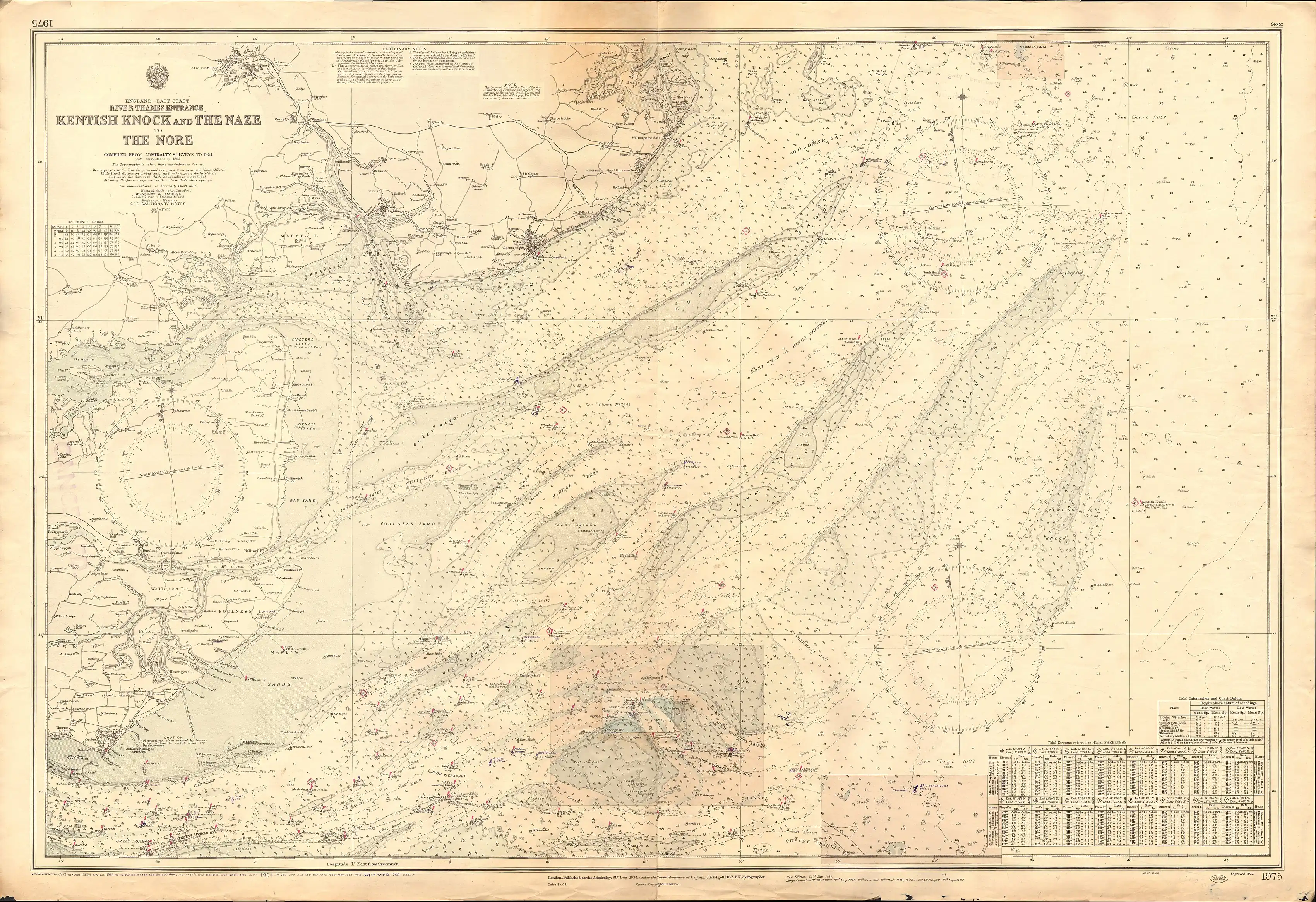
To explain the numbers on the inset map a depth of 11 is a formula of six feet (i.e. one fathom) and 1 foot. It is 1+1⁄6 fathoms. Some of Kentish Knock is, or was, at chart datum "01". At just one foot in depth it will have become exposed at the ebb phase of most extreme, spring tides.
Maritime history


| Year | Type | Description |
|---|---|---|
| 1652 | Battle | Battle of the Kentish Knock between Dutch Republic and Commonwealth of England |
| 1820 | Navigation aid | First reliable mapping of Kentish Knock by triangulation from Essex, by George Thomas[5] |
| 1821 | Wreck by accident | British merchant ship, the East Indiaman Juliana[6] |
| 1824 | Navigation aid | Buoy placed on the east side of the Knock[7] |
| 1836 | Wreck by accident | British ship the Nancy ran aground, broke up, and was washed up at Margate.[8] |
| 1840 | Navigation aid | Buoy replaced by lightship LV Kentish Knock[9] |
| 1860 | Wreck by accident | Dutch galliott Hillechina[10] |
| 1875 | Wreck by accident | German merchant ship the SS Deutschland[11] |
| 1885 | Wreck by accident | British Liverpool barque Canoese.[12] |
| 1886 | Wreck by accident | Lightvessel rammed by a barque PALADIN, almost cut in two and sank in three minutes. The crew were taken aboard the barque and put ashore.[13] |
| 1892 | Wreck by accident | British merchant ship, SS Dilsberg, of Glasgow[14] |
| 1894 | Navigation aid | Telephone cable laid from mainland to the lightship[15][16] |
| 1916 | Wreck by enemy measure | German Empire Zeppelin L15[17][18] |
| 1917 | Wreck by enemy measure suspected | German Empire U-boat SM UC-6, likely by mine nets or by British seaplane 8676[19] |
| 1940 | Wreck by enemy measure | British G-class Destroyer HMS Grenville after triggering a mine. |
| 1949 to 1953 | Navigation aid | Trinity House lightvessel №8 stationed here[20] |
| 1953 to 1955 | Navigation aid | Trinity House lightvessel №14 stationed here[21][22] |
| 1959 and 1963 | Navigation aid | A different lightvessel moored here[23][24] |
| 1963 to 1966 | Navigation aid | Trinity House lightvessel №20 moored here[25] |
| 1974 to 1975 | Navigation aid | Trinity House lightvessel №23 moored here[26] |
| 1984 to 1991 | Navigation aid | Trinity House lightvessel №3 moored here[27] |
| 2011 | Navigation aid | By this date a lighted buoy remained[28] |
| 2014 | Navigation aid | Phase 2 of the London Array wind farm cancelled to protect rare red-throated divers[1] |
See also
- Carnarvon Basin, Australia, where Kentish Knock South-1 is an exploratory oil well in the Mungaroo Sands.[29]
- Dogger Bank, a many-times bigger bank that extends further east, about 150 miles north
References
- "£1bn windfarm scrapped because of red-throated divers", ITV, accessed 2014-04-19
- Kentish Knock East recommended Marine Conservation Zone, Wildlife Trusts, accessed 2014-04-19
- Admiralty Chart "1975: Kentish Knock and the Naze to The Nore. Of 1934.
- Admiralty Chart "1975: Kentish Knock and the Naze to The Nore. Of 1934.
- Robinson, A H W, Marine cartography in Britain: a history of the sea chart to 1855, Leicester University Press, 1962, accessed on Google Books 2014-04-20
- Lloyd's List №5657.
- Purdy, John, The Brasilian navigator; or, Sailing directory for all the coasts of Brasil, to accompany Laurie's new general chart, Volume 1, Oxford University, 1838, accessed on Google Books 2014-04-19
- The Christian's Penny Magazine No. 214, July 9, 1836, accessed on Google Books 2014-04-20
- "Notice to mariners: light at the Kentish Knock", London Gazette, 14 July 1840, accessed 2014-04-19
- The Shipwrecked Mariner, Vol. VII, 1860, pub. George Morrish, London, accessed on Google Books 2014-04-20
- The Wreck of the ‘Deutschland’, English Heritage, accessed 2014-04-19
- "Severe Gale". The Cornishman. No. 339. 15 January 1885. p. 5.
- "The Kentish Knock Lightship Sunk". Thanet Advertiser. No. 1388. Ramsgate. 4 December 1886. p. 3. Retrieved 9 June 2022 – via British Newspaper Archive.
- Essex Review, Volumes 1-3, E. Durant and Company, 1892, accessed on Google Books 2014-04-20
- The Electrical Review, Volume 41, pub. H. Alabaster, Gatehouse & Company, 1897, accessed at Google Books 2014-04-20
- "Telephonic Communication with Lightships", The Electrician, Volume 31, pub. James Gray, 4 August 1893, [accessed on Google Books] 2014-04-20
- "The Dying Gasbag L15", The War Illustrated Deluxe, 1916, details seen on eBay 2014-04-19
- "Sir Charles Wakefield Medal - Zeppelin L15" Archived 3 September 2014 at the Wayback Machine, The First World War Poetry Digital Archive, accessed 2014-04-19
- Dwight R. Messimer, Verschollen: World War I U-boat Losses, Naval Institute Press, 2002, accessed on Google Books 2014-04-19
- "Trinity House lightvessel no. 8" Archived 2014-01-01 at the Wayback Machine, World Lightships, accessed 2014-04-19
- Goleulong 2000 Lightship Archived 2014-04-20 at the Wayback Machine, accessed 2014-04-19
- "Trinity House Lightvessel No. 14" Archived 24 September 2015 at the Wayback Machine, World Lightships, accessed 2014-04-19
- "Christmas For the Men of the Kentish Knock and Sunk Lightships". East Anglian Film Archive. 1959. Archived from the original on 27 October 2014. Retrieved 19 April 2014.
- Kentish Knock (1963); Service vessel; Light vessel, Royal Museums Greenwich, accessed 2014-04-19
- "Trinity House Lightvessel No. 20" Archived 24 September 2015 at the Wayback Machine, World Lightships, accessed 2014-04-19
- "Trinity House Lightvessel No. 23" Archived 24 September 2015 at the Wayback Machine, World Lightships, accessed 2014-04-19
- "Trinity House Lightvessel No. 3" Archived 24 September 2015 at the Wayback Machine, World Lightships, accessed 2014-04-19
- 13/2011 C4 Kentish Knock Lighted Buoy Archived 2014-04-20 at the Wayback Machine, Trinity House, accessed 2014-04-19
- Chevron finds gas at Kentish Knock South-1 well, offshoretechnology.com, accessed 2014-04-19