Kettla Ness
Kettla Ness is a tied island and headland in Shetland.[1] It is connected by the tombolo Minn beach (Banna Minn), to the south end of West Burra, part of the Scalloway Islands.[2][3] The headland itself is conspicuous and circa 160 feet high.[4][5] The island is accessible to walkers via Minn beach and is now uninhabitated.[4] It is principally used for Sheep farming and pasture.[3]
History
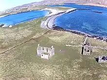
The former settlements of Minn,[6] Gossigarth[7] and Point of Guide[8] lie on the north-west part of the island. The ruined village was principally abandoned following the Highland Clearances in the 19th century although some occupation continued into the early 20th century.[4] There are several other instances of prehistoric activity on the island, primarily at Minn, including several 3rd-1st millennium BC house, cairns, burnt mounds, cists, crop marks and other structures.[4][9][10][11][12][13][14][15] Several of these are located in the Bight of the Sandy Geos, an area on the eastern side of Kettla Ness.[4][16][17] Iron-age pottery fragments have also been found around Sandy Geos.[18][19]
On the south side of Kettla Ness is a stream flowing from the Outra Loch. Along the stream there are numerous examples of ruined historic horizontal watermills that extend down to Groot Ness on the south coast.[20][21][22][23][24]
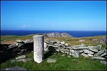
In 1959, a triangulation pillar was erected on the island.
To the west of the island is the wreck of the boat 'Saint Kentigern' which ran aground in November 1979.[25]
Geology and Fauna
There are four small lochs on the island: Virda Vatn, Loch of Annyeruss, Outra Loch and Croo Loch.
Flora on Kettla Ness includes Armeria maritima which is extensive on the south-west coast opposite the Rod Skerries.[4]
Fugla Stack
To the west of Kettla Ness is Fugla Stack, a geological stack landform that consists of vertical columns of rock. There is a wreck, the MV Castor, dating to 1910, beside the stack.[26]
References
- "Kettla Ness". Gazetteer for Scotland. Retrieved 1 May 2023.
- "Minn Beach". Shetland.org. Retrieved 1 May 2023.
- Fitton, Hansom and Rennie (2017). "Dynamic Coast - National Coastal Change Assessment: Cell 11 - Shetland CRW2014/2" (PDF). Dynamic Coast. Retrieved 1 May 2023.
- Moore, Hazel; Wilson, Graeme (March 2001), Shetland Coastal Zone Assessment Survey, Historic Scotland and Shetland Amenity Trust, pp. 75–83
- British Islands Pilot: Faroes, Shetlands, and Orkney Islands and north and east coasts of Scotland. US Government Hydrographic Office. 1915. p. 110.
- Historic Environment Scotland. "Minn (331720)". Canmore. Retrieved 1 May 2023.
- Historic Environment Scotland. "Gossigarth (331721)". Canmore. Retrieved 1 May 2023.
- Historic Environment Scotland. "West Burra, Point Of Guide (190833)". Canmore. Retrieved 1 May 2023.
- Historic Environment Scotland. "Gossigarth (673)". Canmore. Retrieved 1 May 2023.
- Historic Environment Scotland. "West Burra, Minn (636)". Canmore. Retrieved 1 May 2023.
- Historic Environment Scotland. "West Burra, Minn 2 (643)". Canmore. Retrieved 1 May 2023.
- Historic Environment Scotland. "West Burra, Minn 3, House (640)". Canmore. Retrieved 1 May 2023.
- Historic Environment Scotland. "West Burra, Minn 4, House (642)". Canmore. Retrieved 1 May 2023.
- Historic Environment Scotland. "West Burra, Minn 2, House (639)". Canmore. Retrieved 1 May 2023.
- Historic Environment Scotland. "West Burra, Minn 1 (641)". Canmore. Retrieved 1 May 2023.
- Historic Environment Scotland. "West Burra, Bight Of The Sandy Geos (578)". Canmore. Retrieved 1 May 2023.
- Historic Environment Scotland. "West Burra, Bight Of The Sandy Geos, House (580)". Canmore. Retrieved 1 May 2023.
- Historic Environment Scotland. "West Burra, Bight Of The Sandy Geos (583)". Canmore. Retrieved 1 May 2023.
- Historic Environment Scotland. "West Burra, Bight Of The Sandy Geos (581)". Canmore. Retrieved 1 May 2023.
- Historic Environment Scotland. "West Burra, Groot Ness (190793)". Canmore. Retrieved 1 May 2023.
- Historic Environment Scotland. "West Burra, Groot Ness, Horizontal Mill (69722)". Canmore. Retrieved 1 May 2023.
- Historic Environment Scotland. "West Burra, Groot Ness, Horizontal Mill (69723)". Canmore. Retrieved 1 May 2023.
- Historic Environment Scotland. "West Burra, Groot Ness, Horizontal Mill (69724)". Canmore. Retrieved 1 May 2023.
- Historic Environment Scotland. "Example (69725)". Canmore. Retrieved 1 May 2023.
- Historic Environment Scotland. "Saint Kentigern (320978)". Canmore. Retrieved 1 May 2023.
- Historic Environment Scotland. "Castor: Fugla Stack, West Burra, Atlantic (240234)". Canmore. Retrieved 1 May 2023.