Keweenaw Fault
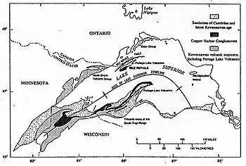
The Keweenaw Fault is a reverse fault that bisects the Keweenaw Peninsula of the Upper Peninsula of Michigan.[1] The fault thrusts lava flows of the Midcontinent Rift System onto sedimentary rocks of the Jacobsville Sandstone. The fault is part of the inversion of the Midcontinent Rift where a region that had previously undergone extension experienced significant contraction. This contraction occurred during the final stages of the Grenvillian orogeny.[2] The Keweenaw Peninsula, itself, is the southeastern side of a large syncline beneath Lake Superior. The northwestern side forms Isle Royale.[3]

The fault is more than 100 miles (160 kilometers) long and extends from the tip of the Keweenaw Peninsula in the northeast to a termination near the Michigan-Wisconsin border in the southeast.[4] The fault is most likely younger than the Jacobsville Formation and the Devonian Period.[5]
A seismic event in 1906 claimed to be an earthquake has been attributed to a rock burst, as the area has been significantly mined.[6]
The Natural Wall
One significant feature along the Keweenaw Fault is known as the Natural Wall. The Wall is a near-vertical slope of the Jacobsville Sandstone which dips as steeply 85°.[7] The steep dip of the Jacobsville Sandstone is the result of it being folded due to motion on the fault.
References
- Brandes, Paul. "Geology of the Keweenaw Peninsula, Michigan". mindat.org. Retrieved March 4, 2012.
- Hodgin, E. B., Swanson-Hysell, N. L., DeGraff, J. M., Kylander-Clark, A. R. C., Schmitz, M. D., Turner, A. C., Zhang, Y., Stolper, D. A. (2022), Final inversion of the Midcontinent Rift during the Rigolet Phase of the Grenvillian Orogeny, Geological Society of America
- Huber, N. King (1975). "The Geologic Story of Isle Royale National Park". United States Geological Survey. Retrieved February 2, 2008.
- Hamblin, W.M. Kenneth (1958). The Cambrian Sandstones of Northern Michigan (PDF) (Report). State of Michigan Department of Conservation. p. 47. Retrieved February 16, 2012.
- Hamblin, W.M. Kenneth (1958). The Cambrian Sandstones of Northern Michigan (PDF) (Report). State of Michigan Department of Conservation. p. 48. Retrieved February 16, 2012.
- McLaren, Noël (August 30, 2011). "Could the Keweenaw Fault become active?". Upper Michigan's Source. Retrieved March 4, 2012.
- Irving, E. D.; Chamberlin, T. C. (1885). "Observations on the Junction Between the Eastern Sandstone and the Keweenwaw Series on Kweweenaw Point, Lake Superior" (PDF). State of Michigan. Retrieved July 21, 2011.