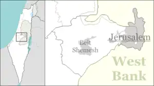
Kfar Uria
Kfar Uria (Hebrew: כְּפַר אוּרִיָּה, lit. 'Uriah Village') is a moshav in central Israel. Located near Beit Shemesh in the Shephelah. It falls under the jurisdiction of Mateh Yehuda Regional Council. In 2021 it had a population of 914.[1]
Kfar Uria
כפר אוריה كفار اورياء | |
|---|---|
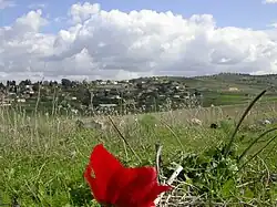 Kfar Uria, 2006 | |
 Kfar Uria | |
| Coordinates: 31°47′37″N 34°56′54″E | |
| Country | Israel |
| District | Jerusalem |
| Council | Mateh Yehuda |
| Affiliation | Moshavim Movement |
| Founded | 1912 (original village) 1944 (first re-establishment) 1949 (second re-establishment) |
| Population (2021)[1] | 914 |
History
The village was first established in 1912 on land purchased by the Palestine Office (Palaestinaamt).[2] It was named after the Arab village of Kafrûria, an "abandoned or sparsely populated" estate situated about half a kilometer west of the new settlement.[3] These lands were to serve as an agricultural training place.[2] Among the village's early founders and residents was A. D. Gordon.[2]
According to a census conducted in 1922 by the British Mandate authorities, Kfar Uria had a population of 40 Jews.[4] The census in 1931 recorded 10 Muslim inhabitants living in 2 houses.[5]
In the 1929 Palestine riots Arab rioters from Jerusalem attacked Kfar Uria, with some local help, robbed and burned down the village. The inhabitants of the adjacent Arab villages for the most part were on good terms with the village's residents and many treated the moshav's association director, Baruch Yakimovsky, as their mukhtar (village chief). He was on amicable terms with mukhtars in surrounding villages. The farmers of the area, both Jews and Arabs, cooperated and defended each other against raiding nomadic Bedouin.
Six Jewish families who had stayed behind were later smuggled out by the mukhtar of Beit Far via one of the ancient natural tunnels that crisscrosses the area. Yakimovsky managed, with the cooperation of some local mukhtars to work Kfar Uria's land for a few more years. In 1944, Jewish stonecutters from Kurdistan rebuilt the village[6] on the ruins of the original site, around 1.5 km north-west Khirbat Ism Allah, but not on village land.[7]
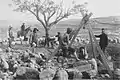 Kfar Uria village well 1912
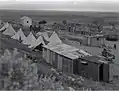 Kfar Uria 1945
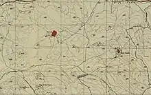 Kfar Uria 1942 1:20,000
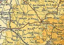 Kfar Uria 1945 1:250,000
The new village was attacked on 11 January 1948, but repelled by a combination of a Palmach force and an armoured British unit.[8][9] Haganah guards murdered without provocation an Arab peasant couple near the village soon after, in February of that year.[10] A third attempt to settle the area was undertaken in 1949, when a moshav was established on the site. The village name is similar to that of Khirbet Cafarorie, a ruin located south - west of the village, which had a rock-hewn winepress, a mosaic and burial caves.
The village center features an old Khan, which once hosted the agricultural training workers, including A. D. Gordon. The Khan structure remains to this day at the heart of the community, but it requires renovations and therefore closed to visitors.
Between 2009 and 2011 a new neighborhood was built and populated with 69 new houses and families.
In 2013, an archaeological survey was conducted at the site by Irina Zilberbod on behalf of the Israel Antiquities Authority (IAA).[11]
Landmarks
In 1970, Israeli artist Avraham Ofek created a mural for the community center at Kfar Uria. The mural, which covers three walls, each 12.5 meters long and three meters high, tells the story of Israel focusing on the themes of immigration, building the country, and family and Jewish tradition.[12]
See also
References
- "Regional Statistics". Israel Central Bureau of Statistics. Retrieved 22 February 2023.
- Ben-Yosef, Sefi [in Hebrew], ed. (n.d.). Israel Guide - Judaea (A useful encyclopedia for the knowledge of the country) (in Hebrew). Vol. 9. Jerusalem: Keter Publishing House, in affiliation with the Israel Ministry of Defence. pp. 278–279. OCLC 745203905., s.v. כפר אוריה
- Marom, Roy (2022-11-01). "Jindās: A History of Lydda's Rural Hinterland in the 15th to the 20th Centuries CE". Lod, Lydda, Diospolis (1): 26.
- "Palestine Census ( 1922)".
- Mills, 1932, p. 21
- Kark, Ruth; Glass, Joseph B. (2000). "The Jews in Eretz-Israel/Palestine: From Traditional Peripherality to Modern Centrality". In Karsh, Efriam (ed.). Israel: The First Hundred Years. Vol. I: Israel's Transition from Community to State. London: Taylor & Francis. p. 101. ISBN 9780714680248.
- Khalidi, Walid (1992), All That Remains, Washington D.C.: Institute for Palestine Studies, p. 296, ISBN 0-88728-224-5
- Benvenisti, Meron, Maxine Kaufman-Lacusta (translator) (2001), Sacred Landscape: The Buried History of the Holy Land Since 1948, p. 107 ISBN 0-520-23422-7
- Morris, Benny (2008). 1948: A History of the First Arab-Israeli War. New Haven, Connecticut: Yale University Press. p. 102. ISBN 9780300145243.
- Morris, Benny (2008). 1948: A History of the First Arab-Israeli War. New Haven, Connecticut: Yale University Press. p. 80. ISBN 9780300145243.
- Israel Antiquities Authority, Excavators and Excavations Permit for Year 2013, Survey Permit # A-6717
- Ashkenazi, Eli (September 7, 2012). "Wall of Rot: Historic Murals Neglected for Years". Haaretz. Retrieved May 2, 2019.