Khachna
The Khachna Range (Arabic: جبال الخشنة, Jibal Khashna; Berber Adrar n Kheshna) is a mountain range of the Tell Atlas, part of the Atlas Mountain System. It is located in Kabylie, Algeria.[1]
| Khachna Massif | |
|---|---|
| جبال الخشنة | |
 | |
| Highest point | |
| Peak | Bouzegza Mount, Bouzegza Keddara |
| Elevation | 1,032 m (3,386 ft) |
| Geography | |
| Location | Kabylia |
| Country | |
| Region | |
| Geology | |
| Formed by | Tell Atlas |
| Mountain type | Mountain range |
Geography
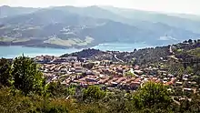
The Khachna is a massif made up of two differentiated ranges, one in the north between Thénia and Zemmouri, and the other in the south between Thénia and Lakhdaria.[2]
Its highest point, Bouzegza Mount known in Kabylian as Athrar Azegzaw, has an elevation of 1,083 metres (3,553 ft) and it is located in the southern subrange.[3]
Other notable summits are the 710 m high Djerrah Mount, a peak located in the central area of the massif, a second highest point of the southern subrange.[4]
Villages
This mountain range is home to dozens of villages including:
- A
- B
- C
- E
- F
- L
- O
- T
Summits
Several mountain peaks are found in this mountain range:[5]
Forests
The plant cover in this mountain range shelters several forests including:
- Boukram Forest
- Corso Forest
- Zbarbar Forest
- Zemmouri Forest
Rivers
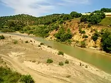
This mountain range is crossed by dozens of rivers:
- Arbia River
- Boudouaou River
- Oued Boumerdès
- Oued Corso
- Hamiz River
- Isser River
- Keddache River
- Meraldene River
Dams

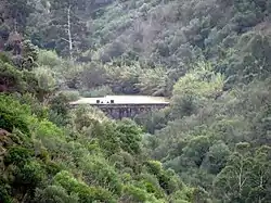
Several hydraulic dams have been built on the waterways of this mountain range:
- Keddara Dam
- Meraldene Dam
- Beni Amrane Dam
- Hamiz Dam
Gallery
![Bouzegza Mount [ar]](../I/Mont_Bouzegza_vue_du_village_zouggara.JPG.webp) Bouzegza Mount
Bouzegza Mount Bouarous Mount
.jpg.webp)
References
- Hanoteau, Adolphe; Letourneux, Aristide Horace (1893). "La Kabylie et les coutumes kabyles".
- "Bulletin: Stratigraphie. 2. Sér". 1891.
- "Bulletin de la Société géologique de France".
- Ficheur, Louis Emile (1890). "Description géologique de la Kabylie du Djurjura: étude spéciale des terrains tertiaires".
- Duparc, Louis; Pearce, Francis Barrow; Ritter, Etienne (1900). "Les roches éruptives des environs de Ménerville (Algérie): Etude pétrographique".
- Lefebvre, Henri (1900). "Les forêts de l'Algérie".
- "Bulletin de la Société géologique de France".
- Ficheur (1890). "Les terrains éocènes de la Kabylie du Djurjura".
- Duparc, Louis; Pearce, Francis Barrow; Ritter, Etienne (1900). "Les roches éruptives des environs de Ménerville (Algérie): Etude pétrographique".
- "Bulletin de la Société géologique de France". 1899.
- France, Société Géologique de (1895). "Bulletin de la Société géologique de France".
| Tell Atlas |
|
|---|---|
| Saharan Atlas |
|
| Saharan massifs | |
| Peaks |
|