Khudan (river)
The Khudan (Russian: Худан, also: Худун, Кудун, Кодун)[1] is a river in Buryatia, southern East Siberia, Russia. It is 252 kilometres (157 mi) long, and has a drainage basin of 7,820 square kilometres (3,020 sq mi).[2]
| Khudan | |
|---|---|
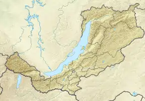 Mouth location in Buryatia, Russia | |
| Location | |
| Country | Russia |
| Federal subject | Buryatia |
| Physical characteristics | |
| Source | Khudan Range Selenga Highlands |
| • coordinates | 52°03′54″N 111°41′44″E |
| • elevation | 1,140 m (3,740 ft) |
| Mouth | Uda |
• coordinates | 52°07′25″N 109°40′54″E |
• elevation | 649 m (2,129 ft) |
| Length | 66 km (41 mi) |
| Basin size | 787 km2 (304 sq mi) |
| Discharge | |
| • average | 12.7 m3/s (450 cu ft/s) |
| Basin features | |
| Progression | Uda→ Selenga→ Lake Baikal→ Angara→ Yenisey→ Kara Sea |
Its average flow rate at the mouth is 12.7 m³/s.
Course
The Khudan is a left tributary of the Uda, of the Selenga basin. The river has its sources in the Khudan Range by the junction with the Tsagan-Khurtei range, 5 km (3.1 mi) to the northwest of 1,554 m (5,098 ft) high Mount Khudan, about 120 km (75 mi) west of Chita. The Khudan flows roughly in a WNW direction and meets the Uda 200 kilometres (120 mi) from its mouth in the Selenga.[3] The river is generally frozen from mid-October or early November until April or May.
See also
References
- Словарь названий гидрографических объектов России и других стран — членов СНГ Archived 2016-03-06 at the Wayback Machine, Federal Service for Geodesy and Cartography of Russia, 1999, p. 418
- "Река Кудун (Худун) in the State Water Register of Russia". textual.ru (in Russian).
- "N-49 Chart (in Russian)". Retrieved 30 September 2021.
This article is issued from Wikipedia. The text is licensed under Creative Commons - Attribution - Sharealike. Additional terms may apply for the media files.