Ōhau
Ōhau is a village and semi-rural community in the Horowhenua District and Manawatū-Whanganui region of New Zealand's North Island.[3] It is located just south of Levin on State Highway 1.
Ōhau | |
|---|---|
Rural settlement | |
| Coordinates: 40.662°S 175.250°E | |
| Country | New Zealand |
| Region | Manawatū-Whanganui region |
| Territorial authority | Horowhenua District |
| Wards |
|
| Electorates | |
| Government | |
| • Territorial Authority | Horowhenua District Council |
| • Regional council | Horizons Regional Council |
| • Horowhenua Mayor | Bernie Wanden |
| • Ōtaki MP | Tim Costley |
| • Te Tai Hauāuru MP | Debbie Ngarewa-Packer |
| Area | |
| • Total | 6.12 km2 (2.36 sq mi) |
| Population (June 2023)[2] | |
| • Total | 830 |
| • Density | 140/km2 (350/sq mi) |
The New Zealand Ministry for Culture and Heritage gives a translation of "place of Hau" for Ōhau, but an alternative meaning could be "windy place".[4]
The former Ohau railway station is located in Ohau.[5] It operated from 1886 to 1987,[6] with most services ending in 1971.[7]
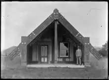
Marae
The local Kikopiri Marae and Kikopiri meeting house are a tribal meeting ground for the Ngāti Raukawa hapū of Ngāti Hikitanga and Ngāti Kikopiri.[8][9]
In October 2020, the Government committed $335,056 from the Provincial Growth Fund to upgrade Kikopiri Marae and Kererū Marae, creating 48 jobs.[10]
Demographics
Ōhau is defined by Statistics New Zealand as a rural settlement and covers 6.12 km2 (2.36 sq mi).[1] It had an estimated population of 830 as of June 2023,[2] with a population density of 136 people per km2. It is part of the larger Ōhau-Manakau statistical area.
| Year | Pop. | ±% p.a. |
|---|---|---|
| 2006 | 438 | — |
| 2013 | 561 | +3.60% |
| 2018 | 666 | +3.49% |
| Source: [11] | ||
Ōhau had a population of 666 at the 2018 New Zealand census, an increase of 105 people (18.7%) since the 2013 census, and an increase of 228 people (52.1%) since the 2006 census. There were 249 households, comprising 351 males and 315 females, giving a sex ratio of 1.11 males per female, with 93 people (14.0%) aged under 15 years, 96 (14.4%) aged 15 to 29, 309 (46.4%) aged 30 to 64, and 168 (25.2%) aged 65 or older.
Ethnicities were 95.5% European/Pākehā, 11.3% Māori, 1.4% Pasifika, 1.8% Asian, and 0.5% other ethnicities. People may identify with more than one ethnicity.
Although some people chose not to answer the census's question about religious affiliation, 52.3% had no religion, 36.0% were Christian, 0.5% had Māori religious beliefs, 0.5% were Hindu, 0.5% were Muslim and 0.9% had other religions.
Of those at least 15 years old, 81 (14.1%) people had a bachelor's or higher degree, and 117 (20.4%) people had no formal qualifications. 93 people (16.2%) earned over $70,000 compared to 17.2% nationally. The employment status of those at least 15 was that 264 (46.1%) people were employed full-time, 87 (15.2%) were part-time, and 15 (2.6%) were unemployed.[11]
Ōhau-Manakau
Ōhau-Manakau statistical area, which includes Manakau, covers 42.23 km2 (16.31 sq mi)[1] and had an estimated population of 2,530 as of June 2023,[12] with a population density of 59.91 people per km2.
| Year | Pop. | ±% p.a. |
|---|---|---|
| 2006 | 1,791 | — |
| 2013 | 1,785 | −0.05% |
| 2018 | 2,154 | +3.83% |
| Source: [13] | ||
Ōhau-Manakau had a population of 2,154 at the 2018 New Zealand census, an increase of 369 people (20.7%) since the 2013 census, and an increase of 363 people (20.3%) since the 2006 census. There were 825 households, comprising 1,086 males and 1,065 females, giving a sex ratio of 1.02 males per female. The median age was 51.4 years (compared with 37.4 years nationally), with 318 people (14.8%) aged under 15 years, 291 (13.5%) aged 15 to 29, 969 (45.0%) aged 30 to 64, and 573 (26.6%) aged 65 or older.
Ethnicities were 84.7% European/Pākehā, 17.3% Māori, 3.1% Pasifika, 5.2% Asian, and 1.0% other ethnicities. People may identify with more than one ethnicity.
The percentage of people born overseas was 17.1, compared with 27.1% nationally.
Although some people chose not to answer the census's question about religious affiliation, 52.8% had no religion, 35.1% were Christian, 0.4% had Māori religious beliefs, 0.6% were Hindu, 0.1% were Muslim, 0.4% were Buddhist and 1.5% had other religions.
Of those at least 15 years old, 249 (13.6%) people had a bachelor's or higher degree, and 441 (24.0%) people had no formal qualifications. The median income was $27,600, compared with $31,800 nationally. 243 people (13.2%) earned over $70,000 compared to 17.2% nationally. The employment status of those at least 15 was that 849 (46.2%) people were employed full-time, 255 (13.9%) were part-time, and 60 (3.3%) were unemployed.[13]
Education
Ōhau School is a co-educational state primary school for Year 1 to 8 students,[14][15] with a roll of 154 as of April 2023.[16]
References
- "ArcGIS Web Application". statsnz.maps.arcgis.com. Retrieved 19 May 2023.
- "Subnational population estimates (RC, SA2), by age and sex, at 30 June 1996-2023 (2023 boundaries)". Statistics New Zealand. Retrieved 25 October 2023. (regional councils); "Subnational population estimates (TA, SA2), by age and sex, at 30 June 1996-2023 (2023 boundaries)". Statistics New Zealand. Retrieved 25 October 2023. (territorial authorities); "Subnational population estimates (urban rural), by age and sex, at 30 June 1996-2023 (2023 boundaries)". Statistics New Zealand. Retrieved 25 October 2023. (urban areas)
- "The good life beckons in idyllic Ohau". Stuff. Dominion Post.
- "1000 Māori place names". New Zealand Ministry for Culture and Heritage. 6 August 2019.
- New Zealand Railway and Tramway Atlas (First ed.). Quail Map Co. 1965. pp. 3 & 4.
- Pierre, Bill (1981). North Island Main Trunk. Wellington: A.H&A.W Reed. pp. 289–290. ISBN 0589013165.
- Scoble, Juliet (2012). Names & Opening & Closing Dates of Railway Stations in New Zealand, 1863 to 2012. Wellington.
{{cite book}}: CS1 maint: location missing publisher (link) - "Te Kāhui Māngai directory". tkm.govt.nz. Te Puni Kōkiri.
- "Māori Maps". maorimaps.com. Te Potiki National Trust.
- "Marae Announcements" (Excel). growregions.govt.nz. Provincial Growth Fund. 9 October 2020.
- "Statistical area 1 dataset for 2018 Census". Statistics New Zealand. March 2020. 7018999, 7019002–7019004 and 7019008.
- "Population estimate tables - NZ.Stat". Statistics New Zealand. Retrieved 25 October 2023.
- "Statistical area 1 dataset for 2018 Census". Statistics New Zealand. March 2020. Ōhau-Manakau (234800). 2018 Census place summary: Ōhau-Manakau
- "Official School Website". ohau.school.nz.
- "Ministry of Education School Profile". educationcounts.govt.nz. Ministry of Education.
- "Education Review Office Report". ero.govt.nz. Education Review Office.