King's Sedgemoor
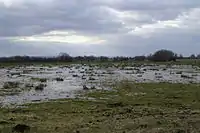
King's Sedgemoor is a piece of rich animal habitat and farming land, that forms part of the Somerset Levels and Moors in South West England.
| Site of Special Scientific Interest | |
 | |
 Location within Somerset | |
| Location | Somerset |
|---|---|
| Grid reference | ST400330 |
| Coordinates | 51.09316°N 2.85815°W |
| Interest | Biological |
| Area | 822 hectares (8.22 km2; 3.17 sq mi) |
| Notification | 1985 |
| Natural England website | |
The area of King's Sedgemoor fell within the Whitley Hundred,[1]
It is a Site of Special Scientific Interest, at the centre of the larger Altcar series peat basin of King’s Sedgemoor; lying between the Sowy River to the west, Cradle Bridge to the east and extending to the south over Beer Wall into part of Aller Moor.[2] It is adjacent to the Greylake SSSI.
King's Sedgemoor Drain, originally constructed in 1797-8, proved inadequate for draining the village of Chedzoy's moors, so in 1861 the Chedzoy Internal Drainage District built a small pumping station on the River Parrett, in Westonzoyland parish, to drain the Chedzoy moors southwards.[3]
References
- "Somerset Hundreds". GENUKI. Retrieved 22 October 2011.
- "King's Sedgmoor" (PDF). English Nature. Archived from the original (PDF) on 26 September 2011. Retrieved 22 October 2011.
- Williams, Michael (1970). The Draining of the Somerset Levels. Cambridge University Press. ISBN 0-521-07486-X.