King Valley
The King Valley, or King River Valley is a wine-producing and agricultural region centred on the King River between Wangaratta and the Alpine National Park in the North East Victoria zone of the Australian state of Victoria. There are a number of small towns within the region including Cheshunt, Whitfield, King Valley, Edi, Claremont, Moyhu, Byrne, Docker and Oxley. King Valley was recorded as an Australian Geographical Indication protected name on 12 October 2007.[1]
| Wine region | |
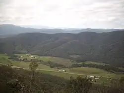 The upper King Valley seen from Powers Lookout | |
| Type | Australian Geographical Indication[1] |
|---|---|
| Year established | 2007 |
| Country | Australia |
| Part of | North East Victoria |
| Heat units | 1350-1580 |
| Precipitation (annual average) | 640 millimetres (25 in) – 1,410 millimetres (56 in)[2] |
History
The fertile valley area has been used since the 1880s to grow a variety of crops which include hops and tobacco alongside dairy and beef cattle production. A narrow-gauge railway was built between Wangaratta and Whitfield in 1889 and a government tobacco research farm was established in Edi and moved to Whitfield in 1902. Following the end of World War II, a large number of Italian, Yugoslav and Spanish migrants settled in the area and established tobacco farms. Following the decline of the tobacco industry in the mid-80s to its demise in 2006 from government deregulation, local farmers branched out into other crops such as chestnuts, hops, berries, and several vineyards were established.[2]
The King Valley has a history which includes bushrangers, Chinese and Italian immigration. The Chinese migrants came from the Goldfields in the mid-19th century and began careers as market gardeners, tobacco growers and merchants. Many roads in the Valley today carry the names of the more prominent families like Mahlooks, Honey, Laffy and Fosangs. Italian migrants came to the region in the 1940s and 1950s, and similarly began tobacco farming however, they would eventually switch to producing European wine varietals. The Valley eventually gained a reputation as a wine region for sangiovese, nebbiolo and barbera varieties amongst others. Some of the highest altitude vineyards in Australia are around 800 metres (2,600 ft) on the Whitlands Plateau at the southern end of the region. Milawa is at the northern end with an altitude of 155 metres (509 ft).[2]
The Whitfield railway line operated in the King Valley from 1899 to 1953. One of four narrow gauge lines of the Victorian Railways, the 50-kilometre line operated from Wangaratta (where it connected with the North East railway line) to Whitfield.[3] Today, this route is a rail trail.
Whitfield and Moyhu are the larger townships in the King Valley, located along the road from Wangaratta or Mansfield. The two towns serve as major tourism centers within the Valley along with the smaller hamlets are dotted throughout the King Valley region.
References
- "King Valley". Register of Protected GIs and Other Terms. Wine Australia. Retrieved 13 July 2016.
- Halliday, James. "King Valley Wine Region". James Halliday’s Wine Atlas of Australia. Retrieved 13 July 2016.
- "Wangaratta to Whitfield Narrow Gauge Railway". members.optusnet.com.au. Retrieved 4 July 2022.
External links
| Central Victoria | 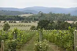 | |
|---|---|---|
| Gippsland | ||
| North East Victoria | ||
| North West Victoria | ||
| Port Phillip | ||
| Western Victoria | ||